New seismic technology could add additional reserves at Qatar’s supergiant North field’s margin
Louis Christian
Dallas Geological Society
Dallas
New seismic technology may unveil even more resources in and around the established boundaries of Qatar’s North field and beneath the Persian Gulf.
Aside from North Field and South Pars, current exploration efforts seek to identify additional shelf-edge porosity trends of Turonian Mishrif and Aptian Shu’aiba types, both east and west of the Qatar Arch.1
Political and economic factors led the US Geological Survey (USGS) and international oil companies to classify the North field as noncommercial nearly a decade after its 1971 discovery.
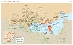
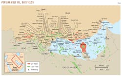
Today North field is estimated to contain 450 tcf of recoverable gas and 16 billion bbl of condensate (Fig. 1). This article discusses lost development opportunities and ideas regarding future exploration within and adjacent to the greater Qatar Arch in the central Persian Gulf. This article also analyzes stratigraphic and structural reasons for the historical growth in reserve estimates by comparing a series of structural contour maps from base Tertiary to base Permian and older.
Structural evolution
More than a decade after gas and condensate were discovered in Upper Permian or Permo-Triassic Khuff formation, Shell, Wintershall, and others had drilled 12 appraisal wells in what was then called the North Dome. USGS Circular No. 881 classified the region as not commercial.
By 1985, various oil companies, including Mobil Oil International, were estimating reserves to be in the 100-150 tcf range. The Qatari government offered a development and production contract to Mobil covering the entire North field structure offshore Qatar, at which time Mobil began a reappraisal of this large farmout.
The appraisal inspected structural maps, planimetered trap size, seismic data, carbonate reservoir characteristics, electric logs, formation tests, and other analyses by previous operators. It identified probable reserves of at least 400 tcf of natural gas and 1-2 billion bbl of condensate. Royal Dutch Shell PLC’s deep Matbakh No. 2 well showed further upside potential based on unexpected results near the southern tip of North field, which logged about 200 ft of Devonian sandstones exhibiting 14-18% sonic log porosities, high resistivities, and gas-condensate recoveries from sidewall formation interval tester samples.
Shell engineers at the time did not openhole test these pre-Permian zones. Pressures at the Devonian depths were 7,000 psi compared to locally available blow out preventers that were rated to 5,000 psi.
Despite the 1985 reappraisal, Mobil declined the opportunity to develop the field. By 1988, other studies suggested the field’s proved gas reserves were 150 tcf with probable reserves between 300-400 tcf.2 In 2017, Iranian sources placed proved reserves for the combined fields in Iran and Qatar at 500 tcf with 18 billion bbl of condensate (OGJ, Jan. 2, 2017, p. 38).
Shared boundary
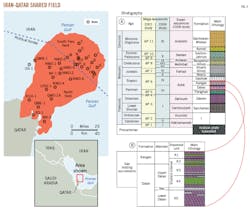
Iran and Qatar have disputed for many years the reserves portions and the northern extension of the structural trap across the maritime boundary of the two countries (Fig. 2). Seismic maps and limited well data show that Iran could have 10%-15% percent of the combined North field reserves in its South Pars.3
By 2017, Iran claimed as much as 38% of the North field’s reserves as lying within its territory. Such claims have not been pressed by Iran, perhaps because the US Navy and Air Force have been invited to establish bases in Qatar, Bahrain, and Oman.
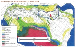
Looking at the Qatar peninsula structure, Fig. 3 is a simplified surface geologic map of the Middle East.3 North field figures prominently near the center of the Persian Gulf. It measures 170 km long by 90 km wide. Condensate-rich reserves are in several stacked-carbonate pays separated by thin anhydrite seals of Permian or Permo-Triassic age scattered through a gross thickness of 1,000 ft of Khuff formation.
Some 300 km southwest of North field, Ghawar holds about 90 billion bbl of oil, mostly in carbonate reservoirs, also sealed by interbedded anhydrites of Late Jurassic age.3 Ghawar is the largest oil field in the world.
Ghawar structure, stratigraphy
The Mesopotamian basin is centered on Iraq northwest of the Ghawar-North field Central Arabian Arch region. The Rub’al Khali depocenter lies to the southeast in southern Saudi Arabia and the United Arab Emirates. Both North field and Ghawar have producing areas of 1.5 million acres or more. Ghawar field is important to North field geology regarding its structural and stratigraphic gradients.
Structural flanks of the North field and Ghawar are gentle, and most flanks in Middle East oil and gas fields are 1°-2°, and less than 0.5° in some cases. Exceptions include the tightly folded, overturned, or thrusted Zagros folds on the Iranian side of the Gulf and the faulted or salt-intruded and deformed structures where pre-Cambrian, Jurassic, or younger salt exists. The extremely gentle structural gradients are most common on the Arabian Shield shelf-slope side of the basin west of the Persian Gulf.
The structure of Middle East fields led 1930s Standard Oil Co. of California (SOCAL) geologists, seismic crews, and engineers to question whether roll-over anticlinal axes could even be recognized and mapped seismically.4
After several tens of km of flat to monotonously gentle East dips, SOCAL almost gave up looking for an eventual west dip at Ghawar. Only after one geologist flew over what later became Ghawar field in a canvas-winged biplane, was he able to plead for geophysical crews to keep shooting seismic profiles farther westward where he thought he could see from the air vague surface hints of counter-regional westward slopes.
As has been well documented in Saudi Aramco employee newsletters, SOCAL came very close to shutting down its entire Saudi Arabian operation following initial failures. A final well was spudded on Dammam Dome on the coast midway between Qatar and Ghawar, and the order was given to abandon. Fortunately, those orders were ignored by the drillers, who thought it would be a good idea to drill a few hours longer until the last drill bit was dulled. They penetrated a good Jurassic carbonate reservoir which flowed clean oil to the surface.
On Aug. 31, 1938, the official production test at the Dammam No. 7 well produced 5,800 b/d of oil from the Upper Jurassic Arab formation.5
Regional mapping
The North field straddles the Qatar-Iran political boundary. The assumption is often the stratigraphy is pancaked with concordant Tertiary, Mezozoic, and even Paleozoic structural closures north and south along the Qatar axis, but this is not the case. The regional top Cretaceous closure is about 50% onshore Qatar and 50% offshore. Surface Quaternary-Tertiary closure is entirely onshore Qatar.
The near-top Jurassic closure is about 70% shifted northward into the offshore because of a gentle southward thickening of most Cretaceous stratigraphic units into the Rub’al Khali depocenter.6
At the Permo-Triassic level, more than 90% of the actual Khuff formation has now shifted into the offshore.6 The map would require considerable revision if we accept the current Iranian reinterpretation of new well data and seismic mapping.
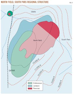
By 2017, Iran had enough marine seismic and offshore drilling data to extend its productive area farther north (Fig. 4). Structural shifting of closure at Permian depths due to further Jurassic and Triassic thickness changes is also evident. Fig. 4 shows the Jurassic structural centroid at North Dome some 24 miles (38 km) northward of the Cretaceous structural apex, and the Permian structural high (culmination or centroid) about 27 miles (43 km) northeast of the Cretaceous high.
Therefore, any thought that monotonously low-angle structural dips and rather gradual lateral thickness changes within Tertiary, Mesozoic, and even Paleozoic stratigraphic layers might make for simple subsurface mapping does not work well in this part of the Middle East. Many of the big structures extend so far laterally in map view that even low-angle thickness wedges can sometimes increase, decrease, or reverse the direction of structural gradients in the deeper subsurface.
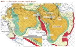
Fig. 5 emphasizes these effects further into less explored areas. On this regional map, the subcrop beneath the Permo-Carboniferous is interpreted to the maximum possible extent. Here again, the greater Middle East sedimentary basin is divided into the huge Mesopotamian basin of Iraq, northwest Iran, Syria, and southeast Turkey vs. the huge Rub’al Khali basin of Saudi Arabia and adjacent Emirates. As stated earlier, these two sedimentary basins or sub-basins are separated from each other by the Kuwait Arch-Central Arabian Arch areas where Late Permian sediments sometimes overlie pre-Cambrian, granite, or metamorphic basement. Other less angular unconformities exist in the Middle East, but this one is the most severe.7
The Kuwait Arch and parallel or subparallel down-faulted west flanks of Khurais, Ghawar, and Qatar Arch are thought to be members of a very old family of pre-Cambrian normal faults or half-horst/half-graben blocks, reactivated at various times, and even influencing to some extent the locations of Jurassic and Cretaceous oil traps.7
Sandstone distribution
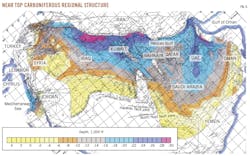
Fig. 6 is a structure contour map showing the regional distribution of Carboniferous or Permo-Carboniferous sandstones which, in recent years, have been producing 0.5-1 million b/d of high-gravity, low-sulphur oil in the Hawtah area south of Riyadh.7 Pre-Permian erosion left bald areas at the Kuwait Arch and the Ghawar structure, and perhaps, parts of the Qatar Arch.
The Shell Matbakh No. 2 well at the southeast edge of North field encountered gas-condensate saturated Devonian or, less likely, Carboniferous sandstones with 14-18% sonic log porosity as mentioned previously. Paleontological evidence of the true age is ambiguous, so the pre-Permian subcrop remains a bit uncertain at North field. Likewise, the nature of the northern plunge of the Qatar Arch in Iranian waters is inconclusively understood. It is possible that other gas reservoirs older than Devonian may be encountered below Iranian waters.
Further exploration
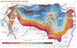
Going back to the regional near-top Permian structure, Fig. 7 shows what a giant uplift the Qatar Arch is in relation to the rest of the greater Middle East. Furthermore, given the shifting structural culminations due to variations in Cretaceous, Jurassic, Triassic, and Permo-Carboniferous sedimentary thicknesses, it should not be surprising if additional oil or gas discoveries occur in reservoir rocks of various ages to the north and south of North field somewhere along the 450 km (280 mile) long axis of the Qatar Arch. Separate deposits have already been discovered, if not entirely developed, in Cretaceous, Jurassic, Permo-Triassic, and Devonian reservoirs.
Several 500,000-1,000,000-acre closed high structures elsewhere in the Middle East appear on this regional Permian structure map. Some of these already have shallow Cretaceous or Jurassic production. Some deserve deeper tests.
There is a known danger of encountering overcooked Silurian and older source rocks in the deepest wells in the UAE east of Qatar, resulting in the migration of increasing fractions of CO2, nitrogen, and other trash gases.8 Even argon and radon, of probable igneous and radioactive origin, have been found in the deepest Khuff formation reservoirs, as well as several ultradeep parts of offshore Dubai, Abu Dhabi, and adjacent parts of Iran, near the Strait of Hormuz.8
On the positive side, both Middle Cretaceous (Turonian) Mishrif carbonate reservoirs and Lower Cretaceous (Aptian) Shu’aiba carbonate reservoirs have proved productive in many parts of the Middle East, from southeast Turkey south through Iraq and Iran to parts of Saudi Arabia, the UAE, and Oman.
Particularly good examples have been published for the Shaybah field area of Saudi Arabia, the Safah field area in Oman, and several oil fields in eastern offshore Qatar and adjacent parts of western offshore Abu Dhabi and offshore Iran. In each of these fields seismic stratigraphy has played an important role in identifying subsurface porous and permeable shelf-edge reservoir trends which separate mixed facies carbonate-evaporate shelf and back reef or lagoonal facies from open marine-to-deep outer marine carbonate-micrite-shale facies,
In 1995-96, Iran offered ConocoPhillips an opportunity to develop and produce the offshore Sirri field. The Sirri field area and the Fateh field area in adjacent western Dubai waters had about 6 billion bbl of oil each in Turonian Mishrif reservoirs comprised of combination stratigraphic-structural traps. The operator negotiated terms agreeable to itself and to the Iranians, but anti-Iranian hawks in the US State Department prevented the company from proceeding with the deal.9 Total SA and others accepted the deal with terms identical to what ConocoPhillips had agreed. OGJ
References
1. Pelissier, J., Hedayati, A., Abgrall, E., and Plique, J., “A Study of Hydrodynamic Activity in the Mishrif Fields Offshore Iran,” Journal of Petroleum Technology, June 1980, pp. 1043-1052.
2. Beydoun, Z., “The Middle East: Regional Geology and Petroleum Reserves,” Scientific Press, Jan. 1, 1988, pp. 292.
3. Christian, L., “Middle East Petroleum Geology Overview,” Dallas Geological Society Lecture, Oct. 28, 2004.
4. Barger, T., “Out in the Blue: Letters from Arabia 1937-46,” Selwa Printers, 2000.
5. Norton, M., “Dammam Well #7,” Aramco World, May-June 1988.
6. Christian, L., “Middle East Geological Map (MEG MAP) Series,” Published by Gulf PetroLink, Bahrain, at 1:4,000,000 scale, 1988-2003.
7. Christian, L., “Subsurface Geologic Atlas of the Middle East Region with explanatory notes, analysis, spread sheets and bibliography,” Dallas, 2005, pp. 346.
8. Christian, L., “Bottom Hole Temperatures, Geothermal Gradients and Oil Source Rock Thermal Maturation Mapping in the Middle East,” Unpublished research lecture to Dallas Geological Society, 2009, pp. 20.
9. Christian, L., “Good News and Bad News from the Middle East: Reserves, Produceability, Future Potential and Possible Economic Consequences,” Lecture to Dallas Geological Society, 2008, pp. 25.
The author
Louis Christian is an international petroleum consultant, retired from Mobil Oil International, with Middle East-Far East experience. Since retiring he has served as a consultant to Bunker Hunt, Anschutz, and Tur-Kan, and written numerous published papers on Middle Eastern geology and issues. He self-published a 346-page subsurface geologic atlas of the Middle East in 2005. A geologist, he has BS and MS degrees from Stanford University.
