Pace speeds up in exploration for Triassic targets in Israel
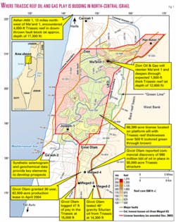
Zion Oil & Gas, an exploration company with offices in Dallas and Israel, is exploring on its 95,800-acre Ma'anit-Joseph License in north-central Israel.
Using all available resources including over 400 km of seismic, well completion data, and gravity-magnetic survey data, Zion is joining in and aggressively pursuing the exploration for hydrocarbons in Israel. Recent discoveries of Triassic oil in north-central Israel have spurred oil companies in their exploration efforts.
Exploration history
Petroleum exploration began in Israel in 1947 on a surface feature in the Heletz area of central Israel.
Since then 470 wells have been drilled in the country, and most have penetrated depths ranging from 1,500 ft to over 21,000 ft. However, many of the wells were drilled on shallow surface features.
The first discovery was the Heletz-1. The well was completed in 1955 and produced oil from Lower Cretaceous Heletz sands (5-30 m thick). The field is estimated to have had some 50 million bbl of 30º gravity oil in place.1
Other onshore fields and discoveries include Ashdod, Kokhav, Zuk Tamrur, Gurim, Meged, and Emunah. Subcommercial and commercial onshore gas fields include Zohar (65 bcf recoverable), Kidod, Kanaim, Sadot (35 bcf), Ashdod, Shiqma, and Notera.
Offshore exploration began in the 1990s with the subsequent discoveries of Noa (300 bcf), Or, Mari-B (1.2 tcf), Nir, and Gaza Marine (1.5 tcf) fields.
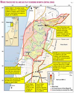
Most recently, exploring in north-central Israel, in April 2004 Givot Olam Oil Ltd., Jerusalem, converted its exploration license to a production lease following oil discoveries in the Triassic Meged-4 well, immediately south of the Ma'anit-Joseph license (Fig. 1).
The objective at Ma'anit is the Triassic reefal dolomite, the Mohilla formation. Many Triassic oil and gas fields are located in the area including Butmah, Sufaiya, and Alan fields in Iraq, Souedie, Rumailan, Jebbissa, and Tishreen fields in Syria,2 and Mila, Gela, and Ragusa oil fields in the central Mediterranean.
On a large structure in north-central Israel, the Ma'anit-1 well was spudded in 1995. The primary objective was Triassic carbonates. However, after reaching a depth of 2,335 m (7,661 ft) with very minor oil shows in the Jurassic section,3 the well was abandoned due to insufficient funds.
Zion was then awarded the Ma'anit-Joseph license, completed its 2001-02 work commitments and now is ready to begin its drilling program.
Tectonics and structure
Located today on the northwestern border of the Arabian-Nubian shield in midlatitudes,4 Israel in Upper Triassic time was in an equatorial position. Carbonate deposition occurred throughout the Proto Mediterranean Sea and Arabian platform.
A large stratigraphic/structural feature was independently confirmed by gravity and magnetics and seismic surveys in north-central Israel within Zion's license area.
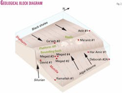
Located on the regional north-south trending structural Gerar high (Fig. 2), Triassic reefs and reefal carbonate sediments formed along this Paleozoic high at Ma'anit and were folded as the result of the Syrian arc compression of Late Cretaceous age which created the commonly named Um al Fahm anticline. These Triassic reefs trend generally east-west.
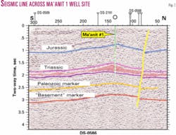
In the northern Ma'anit license area the largest reef, the Ma'anit "A," has been mapped seismically to have an areal closure of some 8,000 acres (Fig. 3). The smaller "B" and "C" reefs combined are 6,000 acres. The Joseph reefs, located in the southern part of the Ma'anit-Joseph License, offer further exploration opportunities.
Ma'anit-1 stratigraphy
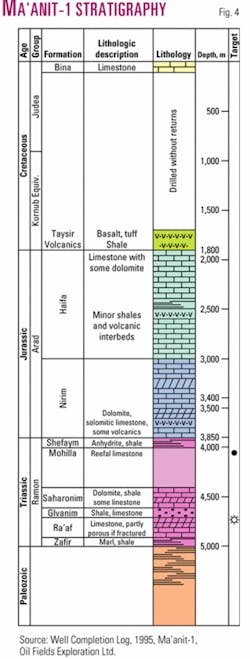
The stratigraphy in the license area is comprised primarily of Cretaceous through Triassic carbonates, shales, evaporites, and intermittent volcanics (Fig. 4).
Ma'anit-1 drilled 1,825 m (5,987 ft) of Upper to Lower Cretaceous carbonates with intermittent volcanics. Upper Jurassic carbonates lie directly below the Cretaceous sediments to a total depth of the well at 2,335 m (7,651 ft).
Well ties with seismic and data from surrounding wells strongly suggest that the top of the Triassic is at 3,850 m (12,631 ft) and the top of the primary objective, the Mohilla reef, is at 4,000 m (13,123 ft). The secondary objective, the Ra'af/Zafir, is expected to be at a depth of 4,600 m (15,092 ft).
Hydrocarbon sources
Four sources account for the hydrocarbons generated in Israel.
The Jurassic Barnea formation sources the coastal oil fields such as Heletz.
In the Dead Sea area, rocks from the Late Cretaceous are believed to be the source.
The sources for the oil found in Triassic reservoirs are considered to be of Triassic and possibly Silurian age.
The recent oil discoveries immediately south of Zion's license suggest a Silurian source. Oil samples in the noncommercial Meged-2 well were analyzed and a Silurian source was identified.
Potential Triassic source rocks are known throughout the region. The Upper Triassic source rocks found in the adjacent Northern Highland-1 well in Jordan contains source rocks with TOCs varying from 0.5% to 1.9%.3
In Israel proper, Triassic source rocks were identified in the Massada-1 (TOC 0.72%), Hazerim-1 (1%), Ramallah-1 (0.8%), Deborah-2A (0.75%), and the Ga'ash-2 (1.65%) wells.5
Reservoir characteristics
The primary reservoir, the Mohilla formation, is Triassic in age (Carnian/ Norian) and is composed of dolomitized reefal carbonates.
The thickness of the Upper Triassic sediments varies from 914 m to 2,385 m. Porosity is estimated to be near 10%.6
Although no oil has been produced from Triassic formations in Israel, the equivalent Kurra Chine formation in Iraq has a similar average porosity of 10% as observed in the Butmah-2 well.2
The secondary reservoir is the Zafir/ Ra'af formations of Middle Triassic age (Anisian/Ladinian). These formations consist of fractured dolomites interbedded with black shales and some limestones.
Porosities range from 6% to 39% in the Ga'ash-2.7
Zion work plan
Zion at present plans to re-enter the Ma'anit-1 well.
The original well encountered minor oil shows from 1,860 m (6,102 ft) to a total depth of 2,335 m (7,661 ft) from Jurassic (Oxfordian to Bathonian) carbonates. However, with encouraging hydrocarbon shows, large structure, multiple Triassic objectives, and new field discoveries directly south of the concession, Zion has a strong probability of making a significant discovery of some 484 million bbl of oil.
After completion of the Ma'anit-1 well, Zion will then explore the Ma'anit "B" and Joseph prospects in the southern part of the concession. The larger areal extent of the Joseph reefs, 12,000 acres in the permit area, provide additional upside potential.
References
1.Oil Fields Exploration, "Ma'anit-1 Well Completion Report," Oil Fields Exploration Ltd., 1995.
2.Sadooni, F., and Alsharhan, A., 2004, "Stratigraphy, lithofacies distribution, and petroleum potential of the Triassic strata of the northern Arabian plate," AAPG Bull., Vol. 88, 2004.
3.Well completion log, Ma'anit-1, Oil Fields Exploration Ltd., 1995.
4.Stoakes, F., "Triassic Reef Project Northern Israel (Ma'anit)," Stoakes Consulting Group, Calgary, Canada, 1991.
5.Cohen Z., "Hydrocarbon Potential of Israel," Oil Exploration (Investments) Ltd., 1988.
6.Harris, J., "Sample Study, No. 1 Asher/Atlit, Israel," John F. Harris Consulting Geologist, unpublished report, 1983.
7."Ga'ash-2 Geological Completion Report," Oil Exploration (Investments) Ltd., 1984.
Bibliography
Ginzburg, A., and Eppelbaum, L., (undated), "A 3-D reinterpretation of the Ma'anit gravity anomaly," Tel Aviv University.
Zion Oil & Gas, "Prospect Presentation for the Joseph Project in Israel, Zion Oil & Gas report submitted to the Israel petroleum commissioner and available to the public in Israel," 2003.
The author
Stephen Pierce ([email protected]) is a consulting geologist with over 25 years' exploration experience worldwide. When working with Superior Oil Co. and exploring in Israel in 1980, he wrote a basin analysis study for the state of Israel at its request. He has a BS degree in geology from Long Beach State University and an MS degree in geology from San Diego State University.
