Bahamas: Gravity data suggest existence of Triassic-Jurassic syn-rift
Allan Spector
Allan Spector and Associates Ltd.
Toronto
Samuel Epstein
Geoval Consulting LLC
New York
David Schieck
Seismic Solutions
Calgary
Recent analyses of gravity, magnetic, and seismic data in the southeastern region of the Bahamas provide clear evidence for the presence of a salt diapir at a depth of 5 km. The salt appears to be Jurassic in age. This is the first indication of the presence of an appreciable thickness of salt within the Bahamian section.
To date, six test wells have revealed the presence of 3-4 km of Upper Mesozoic and Cenozoic carbonates. For the most part, these rocks have proven barren for hydrocarbons.
Gravity data, reprocessing
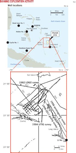
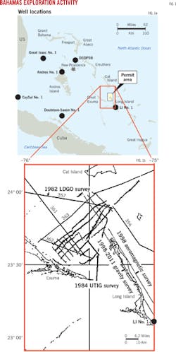
Partly due to the thickness of the Cenozoic-Mesozoic section, exploratory wells in the region rarely tested older rocks (Fig. 1a). To the west, however, Jurassic and older strata beneath Cuba have produced more than 60,000 b/d of oil.
New analyses of an area centered on the north portion of Long Island could further exploration interest (Fig. 1a). As pictured, the Long Island No. 1 (LI No. 1), drilled in 1970, is 30 km southeast of the study area. Oil shows were detected near the bottom of this well (4,850-4,861 m).
During a survey conducted in 1998, we observed an intense -30 milligal (mGal) gravity deflection at the north end of Long Island in what is known as the Columbus Pillow gravity anomaly (CPGA).
This anomaly spurred several further investigations. We reprocessed onshore and marine gravity data collected from several sources 1998-2014 to create a Bouguer gravity map of the Bahamas from more than 2,300 gravity measurements.1 2
The map reveals the presence of several intense negative gravity anomalies with amplitudes of -30 to -100 mGal. The north Long Island anomaly is but one of these.
Also in 1998, Terraquest Ltd. conducted a 220-km aeromagnetic survey of Long Island consisting of two northwest-southeast lines at 150 m altitude.3 Analysis of these data, augmented by magnetic data from University of Texas Institute for Geophysics (UTIG's) 1982 marine survey, revealed the thickness of the sedimentary section under Long Island. Additionally, the magnetic basement also appears to be dislocated in places by faulting.
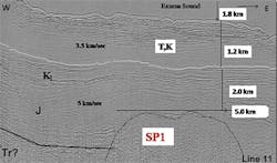
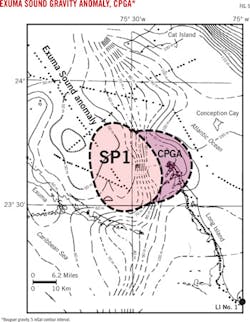
We reprocessed publicly available seismic data from marine surveys shot in 1982 and 1984 by UTIG and the Lamont-Doherty geological observatory (LDGO), respectively. The result showed a prospective, positive structure corresponding both geographically and in depth with the CPGA (Fig. 1b).
Principal geological references to these findings can also be found in a paper by Espstein and Clark, of which our current study is considered a continuation.4
Gravity, magnetic data
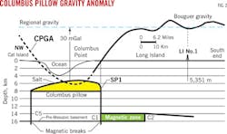
The gravity measurements are spaced 2 km apart along roadways. Modeling showed the CPGA to be consistent with a 3,000-m thick salt "pillow" with density contrast of -0.5 gm/cc. The salt pillow's top is 5 km below sea level (Fig. 2).
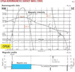
Magnetic intensity data from the 1998 airborne survey of Long Island and the data from the 300-km UTIG marine survey illustrate a profile that is dominated by a 400 nanoTeslas (nT) anomaly in the north part of the island (Fig. 3).5
The estimated thickness of the sedimentary section is 11-14 km. Thus the LI No. 1 well, drilled to 5,355 m, cut only half of the sedimentary section. Several magnetic contacts (labeled as C1-C5) are evident in the data that separate basement rocks of contrasting magnetization (Fig. 3). A graben structure can be interpreted from these breaks between magnetic contacts C1and C5.
Seismic reflection data
In April 1984, UTIG conducted 600 km of marine seismic (Fig. 1b). This study was carried out as a component of Texas A&M University's Ocean Drilling Program. The survey was an effort to understand the geological evolution of the Bahamas, in particular, to map the structure in a carbonate "megaplatform" that was drowned in the Middle Cretaceous during the opening of the Atlantic Ocean. The survey consisted of 22 lines. Processed and stacked seismograms for both the UTIG and LDGO survey lines are publicly available from UTIG's website.
Reprocessing, analysis, and an interpretation of these seismic data showed 1-2 km of sedimentary rocks overlie the buried Middle Cretaceous carbonate platform (Fig. 4).
A noticeable structural high involving pre-Cretaceous rocks is quite clear. This seismic prospect is labeled as SP1.
Because of its spatial association with the CPGA, SP1 is interpreted as a salt diapir. With seismic wave velocities shown in Fig. 4, we estimate the depth to the top of the diapir to be 5 km below sea level.
Bahamas syn-rift
A Triassic-Jurassic syn-rift underlies the central part of the Bahamas.4 What we refer to as the Bahamas rift extends 800 km southwestward from Florida's Sunniland trend oil pools.
Syn-rifts attract exploration interest due to the likely existence of organic-rich sediments, evaporites, reservoir rocks originated from erosion of rift walls, and the relative high-heat flow known to accelerate source rock maturation.6
The Bouguer gravity map of the Exuma-Long Island shows the CPGA (and SP1) to be spatially related to the northeast trending Exuma Sound gravity anomaly (ESGA; Fig. 5). This -60 mGal anomaly can be attributed to an accumulation of lower density sediments that includes a thick layer of salt.
Exploration potential
The ESGA is one of several gravity features observed in the Bahamas that corroborates the presence of the Bahamas rift.
Based on modeling of gravity data, the CPGA is a 3,000-m thick salt diapir buried to 5 km and is coincident with a positive seismic structure.
Magnetic data analysis indicates that the sedimentary section under Long Island is 12-14 km thick and has only been drilled to half this depth (LI No. 1 reached 5.3 km). Additionally, magnetic data indicate considerable rifting of the pre-Cretaceous section, including a possible graben structure that is associated with the interpreted salt diapir.
An interpretation of known gravity data in the region suggests the existence of the Bahamas rift, a Triassic-Jurassic syn-rift that includes significant deposits of evaporites.4
References
1. Ladd, J.W., and Sheridan, R.E., "Seismic stratigraphy of the Bahamas," AAPG Bull. 71, 1987, p. 719-736.
2. Talwani, M., "Gravity anomalies in the Bahamas and their Interpretation," PhD thesis, faculty of Pure Science, Columbia University, 1960, pp. 89.
3. Austin, J.A., Ewing, J.I., Ladd, J.W., Mulland, H.T., and Sheridan, R.E., "Stratigraphic implications of ODF Leg 101 site surveys," proceedings of the Ocean Drilling Program, Scientific Results, Vol. 101, 1988, p. 391-424.
4. Epstein, A.S., and Clark, D., "Hydrocarbon potential of the Mesozoic carbonates of the Bahamas," Carbonates and Evaporites, Vol. 24, No. 2, 2009, p. 97-138N.
5. Spector, A., and Leaver, A., "Application of high resolution aeromagnetic data to Cambrian exploration in the Appalachian basin," Canadian Journal of Exploration Geophysics, Vol. 34, 1997, p. 67-82.
6. Hanson, A.D., "A surprising asymmetric paleothermal anomaly around El Gordo diapir, La Popa Basin, Mexico," AAPG Bull. 98, 2014, p. 213-226.
The authors
Allan Spector ([email protected]) is president of Allan Spector and Associates Ltd., Toronto, and Columbus Pillow Exploration Company Ltd., Bahamas. He has also served as chief geophysicist for Lockwood Surveys, Toronto. He holds a PhD from the University of Toronto and is a member of the Society of Exploration Geophysicists.
Samuel Epstein([email protected]) is associate director of Merrill Lynch, New York. He has also served as senior petroleum geologist at Texaco, Chevron, and Getty Oil Co. He holds an MSC from Rensselaer Polytechnic Institute, Troy, New York, and is a member of the American Association of Petroleum Geologists.
David Schieck([email protected]) is president at Seismic Solutions of Puslinch, Ontario. He has also served as senior geophysicist with Geo-X Systems and Terracon Geophysique, both of Calgary. He holds an MSc from University of Alberta at Calgary. He is a member of the Canadian Society of Geophysicists and the Society of Exploration Geophysicists.
