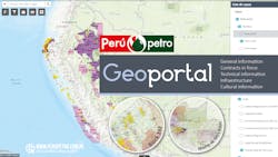
PERUPETRO S.A.’s GEOPORTAL: A glance to the fields and prospects information in Peru
- An interactive map of Peruvian fields with several layers containing interesting and useful information which can be displayed at the whim of the user
- Geophysical data, wells location, production facilities, infrastructure, native communities and protected areas.
- Geologists, geophysicists, managers of new ventures, business developers, engineers, upstream academics and students for research works will find it delightful
The location of the fields and the specificity regarding the information of the blocks in Peru are some of the innumerable advantages offered by the Geoportal of PERUPETRO S.A., which, at first interaction, allows showing the base map of blocks that have contracts in force, as well as those areas that are in permanent promotion, negotiation, technical evaluation or that maintain a simplified process. Additional layers of information can be added to view from technical information such as geophysical data, location of wells, production facilities, infrastructure (refineries, port terminals, road or departmental networks), to social information such as the location of Amazonian native communities and areas protected natural areas.
In it, within the most relevant functionalities is the facility to search for wells, blocks, names of seismic lines, etc., to find a summary of the most relevant data of these; as well as the possibility of downloading the information in shape formats. In relation to geophysics, the platform allows a visualization of the location of all the 2D, 3D seismic, Gravimetry and Magnetometry of the entire country. In addition, it allows the location of the wells, whether they are producers or exploratory, to know the block and reservoir to which they belong, as well as their official name, coordinates, year of drilling and operator that drilled it.
All the information displayed in the Geoportal is contained in the Data Bank. PERUPETRO performs a quality control on the information that is uploaded to said data bank and that it calls Certified Information. For example, in the geoportal you can identify which wells are already certified (passed said quality control) and which wells have not yet (quality control pending). The user will be able to download the information of the certified wells directly from the Data Bank, such as technical reports, profiles, among others.
As mentioned before, PERUPETRO S.A. also makes the Data Bank accessible to the public, which is the ideal complement to go deep into the technical information available on Peru.
The invitation is open to all interested parties, weather geologists, geophysicists, managers of new ventures, business developers, engineers, upstream academics and students for research works who will find these tools very useful and attractive!
To visit the Geoportal, you can access by the BLOCK MAP section or clicking HERE. And if you need assistance or further information, you can write to: [email protected].
