New York Devonian black shale: A Barnett-like play in waiting
Since the inception of oil and gas exploration in New York, geologists have speculated on the potential of the fractured Upper and Middle Devonian shale/siltstone of the Appalachian basin.
Limited historic data and the complexity of fractured reservoirs have inhibited the development of reservoirs in this pay, although numerous shows of oil and natural gas have been reported. Direct Geochemical and Pyron Consulting decided to apply integrated exploration technology methodology to this problem.
In a project co-funded by the New York State Energy Research and Development Authority (NYSERDA), Direct Geochemical and Pyron Consulting completed a study of Genegantslet field, Chenango County, NY. In this study, we integrated subsurface mapping techniques, petrophysical analysis, remote sensing analysis, fracture trace analysis, production history, and surface soil geochemistry to analyze the field.
Based on this study, we believe that we have developed a model that the industry can use to explore for and develop reservoirs of this type in the Appalachian basin.
Background information
Direct Geochemical and Pyron Consulting have had extensive professional experience, both collectively and independently, in analyzing tight sandstone and organic (black) shale gas reservoirs.
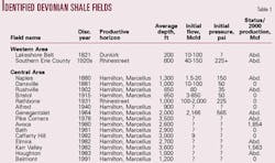
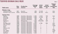
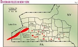
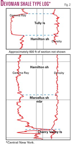
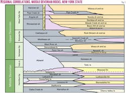
It was a natural extension of this experience that drew us to the question of the Middle Devonian shales of the Northern Appalachian basin. A selected number of multiwell fields and a number of one-well fields were never developed in this horizon (Fig. 1). Table 1 provides more detailed information, including year 2000 production data, for Middle Devonian shale gas fields in New York. A type log for the Middle Devonian is presented in Fig. 2. The regional correlation of Middle Devonian stratigraphy is shown in Fig. 3.
After surveying the information on Devonian shale gas fields, the principal reason we chose Geneganslet field for our analysis was that it is the one field with reasonably complete subsurface data. No electric well logs are available, but accurate driller's logs allowed a better understanding of subsurface stratigraphy.
It is also the field in which the highest initial flow rate (2.166 MMcfd) and highest initial pressure (> 565 psi) were recorded for a Devonian shale well in New York State.
We next determined the proper steps needed to answer the two most pressing questions associated with fractured shale reservoirs:
- Does the shale have sufficient organic content to allow for an economic amount of natural gas to be generated?
- Are sufficient fractures or dual porosity present to allow that natural gas to be withdrawn?
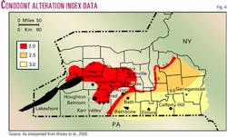
Weary et al.1 addressed the first issue. After geochemical analysis of collected drill cuttings from wells in New York State, they developed a series of geochemical indicator maps that can be used to show favorable areas for the development of Middle and Lower Devonian reservoirs.
Fig. 4 is a Conodont Alteration Index (CAI) map for the Devonian; the authors have modified this map to enhance the data presented in the original map.
We would note that this study was done on samples from wells that ranged from relatively recent to over 30 years old, and that the age and storage methods of the cuttings may have caused a lower reading than would have been obtained from freshly collected samples. We note this not to impugn the methodology used by Weary et al., which was technically sound, but instead to caution that reported results might be lower than actual conditions (i.e., if recently collected samples were analyzed).
We decided to apply the IET methodology to the development of a model for this pay. IET involves the application of a variety of geologic, geochemical, and nonseismic geophysical technologies to the evaluation and identification of hydrocarbon producing reservoirs.
The ideal exploration and development program integrates both seismic and nonseismic technologies as appropriate to the play and prospect conditions. By appropriate, we mean that individual technologies are applied to answering questions that they are best suited to address; when all data are fully integrated, they provide a coherent look at a selected exploration/developmental data problem. The emphasis in IET on nonseismic technologies is two-fold:
- The costs of the technologies are generally a small fraction of that of seismic, even when combined;
- The technologies can be readily integrated into a whole interpretation. This makes the package very powerful as a complement to the appropriate use of seismic methods. Furthermore, it can dramatically reduce overall costs while enhancing success rates.
Thus, IET is readily used by small and medium sized independents who have little staff or technical resources, as well as by multinational companies interested in increasing the cost-effectiveness of their exploration program.
The technologies used in IET vary depending on the type of project, play, amount of existing data, and operator's budget. In lightly drilled or frontier areas, IET will involve not only geochemical and some subsurface geology but remote sensing, fracture trace analysis, gravity, magnetics, and other nonseismic methods, both airborne and ground. An infill drilling project might focus more on subsurface geology and geochemistry. The operator can design the project to address specific needs and questions.
Field methods
The study we completed was limited by the compact nature of the field (i.e., less than one-half mile in length and width) and restricted access.
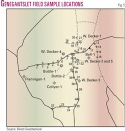
We collected soil gas samples over public roads and developed a grid that extended in one-half mile east and west and at least one-mile north and south of the field's currently defined limits (Fig. 5). A total of 25 representative soil samples were collected during the field event. These samples were logged on a data record sheet and shipped to Direct Geochemical's laboratory in Golden, Colo.
Simultaneously, a subsurface study was completed for the area using sample well log information collected for the wells in Geneganslet field and immediate vicinity.
A regional lineament-tonal anomaly study was created from both a remote sensing study (using both Multispectral Scanner and Thematic Mapper data) and a fracture trace study (using USGS High Altitude Photography). These data were integrated with soil gas and subsurface data to formulate our integrated field model.
'Black shale' production
Data collected by Weary et al.1 and others suggest that the organic content of the Middle Devonian shale is sufficient to act as a source rock.
According to data for Chenango County presented in this report, a black shale sample from a well drilled in the 1960s had the following geochemical indicators:
- Tmax was 505°, within the mature gas index.
- TOC was 2.19%, high to very high.
- % Ro was 1.89.
These values are suggestive of viable source rock for the generation of thermogenic gas. The Weary et al. report also provides CAI maps that show optimum fairways for natural gas occurrence. The authors have modified this map slightly (Fig. 4) to better portray where these drilling fairways are located.
Interestingly enough, the previously discovered Hamilton (Marcellus) fields lie in these optimized areas. If this map is correct, a tremendous fairway exists for addition Devonian shale wells to be drilled.
Earlier reports2 3 also suggest that a broad area in western and central New York has the potential to host natural gas resources. Other reports4 5 6 on a US Department of Energy-funded study to install test wells in southern New York and by NYSERDA7 suggest a favorable resource potential for this area.
Genegantslet analysis
The New York State Department of Environmental Conservation issued the sole report on Genegantslet field, in Smithville and Green Townships, in 1965.
This report notes that the field produces from the Hamilton, which is described as shale interbedded with silty shale possibly grading into silty sand with carbonate (dolomitic) cement.
The author of the DEC report wrote that his subsurface mapping indicates the presence of a Middle Devonian structure. He suggests that successful wells were drilled along pre-existing fractures or possibly a fault. The apparent random drilling pattern identified three wells with significant gas shows (1.9 to 2.2 MMcfd).
The report indicates that daily production of 4.275 MMcfd at a 50 psi line pressure could be established from three wells. The unknown author of this report suggests that the wells could drain 320 acres and were not stimulated. No evidence suggests that the wells were flow tested or produced.
A separate report found in DEC files suggests that an industry group analyzed a "representative" sample of gas from the No. 2 Decker well. This gas was analyzed as having a 96.83% as received concentration of methane and smaller amounts of ethane, propane, and isobutane. The gas had a calculated specific gravity of 0.5614 and a calculated dry heating value of 1,021 BTU/Mcf. The Direct/Pyron team unsuccessfully attempted to retrieve a valid gas sample.
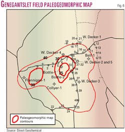
Using the existing data, we developed a series of subsurface maps that integrated individual markers and wellhead reports of shows. The most accurate of these maps (Fig. 6) uses the relative thickness of a marker horizon to model the field's subsurface geology. Based on this map, several areas of thinning of the marker correlate nicely with wells with shows or established flows of gas.
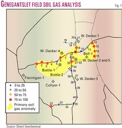
The map that resulted from the analysis of surface soil gas samples (Fig. 7) shows a distinctive anomaly associated with the productive wells in the field. More importantly, the soil gas signature drops off rapidly as one moves away from productive to nonproductive areas.
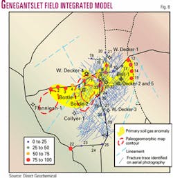
When the soil gas data were integrated with the subsurface map and a fracture trace study (which was completed on an aerial photo mosaic of the area), we developed our integrated model (Fig. 8). The optimum location for wells (i.e., wells with identified flows of gas) seems to coincide with areas in which the soil gas signature, thinning of the paleogeomorphic marker, and identified fractures coincide. The fracture trace study in particular shows that areas with identified fractures but without either the thinning or the soil gas signature yield only dry holes with no identified shows.
Field comparisons
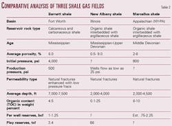
As part of our effort to model the potential of this play, the Direct/Pyron team attempted to compare our observations about the Middle Devonian fractured shale reservoir in Genegantslet field with other productive fractured shale horizons in different basins (Table 2).
Most of the data are collected from previously published technical papers. In addition, we also completed a limited study of the Barnett shale play by obtaining well logs for a portion of Newark East field, Denton County, Tex.
The area that we mapped was on the southern edge of Newark East field. This area was chosen because there is an abrupt change between productive wells of the field and dry holes.
Using a mapping marker, we developed a paleogeomorphic map for this portion of the field. Then we integrated production data to test the map; we specifically used cumulative production for wells that had produced for at least 5 years so that we could eliminate the biases caused by limitations of the completion method or high initial flow-low volume wells.
Using 5-year cumulative production data, we found that the wells with higher cumulative production were located in the most favorable areas of the paleogeomorphic map. We should point out that many data points were commercially unavailable because of operator practices and the newness of infill development.
Still, enough verifiable data was available to make the argument that there is an optimum position for the location of wells in these fractured shale reservoirs. This provides some limited additional confidence in the subsurface map developed for Genegantslet field.
It also seems to verify the points raised by Carlson and Mercer.7 They suggest that successfully developed fractured shale reservoirs have dual porosity—some initial selective porosity caused by preferential accumulation of coarser sediments which is enhanced by imposed fracture systems. Using the paleogeomorphic mapping technique would be one method of identifying where these often-subtle features may exist.
Study outcomes
Direct Geochemical and Pyron Consulting have successfully modeled Genegantslet field by integrating different data streams. From these new data, and by re-examining previous data and well records, we have formulated a model that may be more applicable to the search for natural gas in the Hamilton (Marcellus) reservoir.
The data we collected has successfully modeled the field's subsurface geology. Regional subsurface mapping of the field using the paleogeomorphic mapping technique has revealed a strong correlation between the best producing wells in the field and thinning of the subsurface mapping interval. Addition of the geochemical data supports the trend seen in subsurface mapping.
In addition, the relatively high soil gas concentrations, as based upon soil sample and comparative analysis, shows that the highest concentration contours can be related to the wells with best potential in the field. This, in addition to the favorable comparison with the analog model, suggests that IET methodology is a cost-effective tool for locating black shale reservoirs with limited surface and subsurface control.
Based upon our analysis, the presence of fractures alone is not sufficient reason to produce a fractured shale reservoir. Other features, including some initial porosity, sufficient source materials to fill that reservoir, and a surface signature to optimize the drilling targets, add to exploration success.
Detailed surface geochemistry has aided the precision of analysis by highlighting those areas with the best potential. A combination of the methods used in our IET study could maximize the effect of exploration and developmental capital and insure successful development of this resource.
References
- Weary, David J., Ryder, Robert T., and Nyahay, Richard, "Thermal maturity patterns (CAI and %Ro) in the Ordovician and Devonian Rocks of the Appalachian Basin in New York," US Geological Survey State Open-File Report 00-496, US Geological Survey, Reston, Va., 2001, 24 p.
- Van Tyne, A.M., "Natural Gas Potential of the Devonian Black Shales of New York," Northeastern Geology, Vol. 5, Nos. 3-4, 1983, pp. 209-216.
- Van Tyne, A. M., and Peterson, J.C., "Thickness, Extent of, and Gas Occurrences in Upper and Middle Devonian Black Shales of New York," proceedings Second Eastern Gas Shales Symposium, Vol. 1, METC SP78/6, 1978, pp. 99-126.
- Donohue, Anstey, and Morrill, "Shale Gas of the Southern Central Area of New York State, Vol. I, How to Find and Develop Shale Gas in New York State," ERDA Report 81-18, 231/ET-FUC/80, 1981, 64 p.
- Donohue, Anstey, and Morrill, "Shale Gas of the Southern Central Area of New York State, Vol. II, Experience of Locating and Drilling Four Shale-Gas Wells in New York State," ERDA Report 81-18, 231/ET-FUC/80, 1981, 106 p.
- Arlington Exploration Co., "Shale Gas of the Southern Central Area of New York State, Vol. III, Experience of Drilling Five Shale-Gas Wells in New York State," ERDA Report 81-18, 399/ET-FUC/81, 1983, 105 p.
- New York State Energy Research and Development Authority, 1997.
- Carlson, E.S., and Mercer, J.C., "Devonian Shale Gas Production: Mechanism and Simple Models," JPT, April 1991, pp. 476-482.
Anonymous, Private discussion of the geology of the Barnett shale play, Texas, 2000.
Brett, Carlton E., "Dynamic Stratigraphy and Depositional Environments of the Hamilton Group (Middle Devonian) in New York State," Part 1, NYS Museum Bull. 457, 1986, 156 pp.
Illinois Basin Consortium, "Gas Potential of the New Albany Shale (Devonian and Mississippian) in the Illinois Basin," Gas Research Institute Publication GRI 92/0391, 1994.
Kuuskraa, V.A., Koperna, G., Schmoker, J.W., and Quinn, J.C., "Barnett Shale Rising Star in Fort Worth Basin," OGJ, May 28,1998, pp. 67-76.
Lambert, S.W., and Siegfried, R.W., "Evaluation of Frontier Coalbed Methane and Shale Plays in the United States," Gas TIPS, Summer 2001, Vol. 7, No. 2, pp. 18-19.
Landing, E., and Brett, C.E., "Dynamic Stratigraphy and Depositional Environments of the Hamilton Group (Middle Devonian) in New York State, Part 11, NYS Museum Bull. 469, 1991, 177 pp.
Orton, Edward, "Petroleum and Natural Gas in New York," Bull. of the New York State Museum, Vol. 6, No. 30, 1899, pp. 399-526.
Viellenave, J.H., Fontana, J., and Pyron, A., "Field Modeling-1: Three Exploration Methods Model Gas Field in New York," OGJ, Sept. 11, 2000, pp. 42-46.
Viellenave, J.H., Fontana, J., and Pyron, A., "Field Modeling-2: How Integrated Exploration Technology Helped Answer Questions in an Appalachian Field," OGJ, Sept. 18, 2000, pp. 36-44.
Viellenave, J.H., Fontana, J., and Pyron, A., "Integrated Exploration Technology Targets Trenton-Black River and Shale Reservoirs," Presentation at the IOGA NY fall meeting, November 2001, Buffalo, NY.
The authors
Art Pyron is sole proprietor of Pyron Consulting. He has 20 years of experience in oil and gas exploration and appraisals, minerals investigations, environmental studies, and site remediation. He has an MS in geology from the University of Texas at El Paso.
Jim Viellenave ([email protected]) is a principal geochemist at Direct Geochemical Services in Golden, Colo. He has been involved in surface geochemical exploration for mineral, geothermal, and petroleum resources since 1978. Before that he was with NERI and Earth Sciences Inc. He holds degrees in geography from the University of California.
John V. Fontana is a principal geochemist at Direct Geochemical Services. He has been involved in surface geochemical exploration for mineral, geothermal, and petroleum resources since 1981. Previously he was with the geochemical exploration division of Analex Corp. He holds degrees in geology, physics, and oceanography from Humboldt State University.
