Geologic hydrogen offers twice as much energy as natural gas
In a recent paper, US Geological Survey (USGS) geologists Geoff Ellis and Sarah Gelman estimated large potential for—and large uncertainty about—the amount of hydrogen accumulations in the world. “We calculate the energy content of this estimated recoverable amount of hydrogen to be roughly twice the amount of energy in all the proven natural gas reserves on Earth,” Ellis and Gelman wrote.1
The model, however, makes no predictions about how or where this hydrogen is distributed in the subsurface. The authors note that much of it is likely too deep, too far offshore or in accumulations too small to be economically recoverable.
“We showed there is a significant potential for geologic hydrogen as an emerging energy resource. The next logical step was to find where it might be in the US; and for that, we had to develop a methodology, which we applied first to the lower 48 states,” Gelman said.
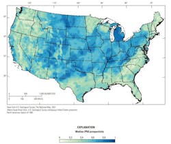
A new USGS prospectivity map assesses which regions have the necessary geological conditions—hydrogen sources, reservoir rocks, and seals to trap the gas—for hydrogen accumulation. The map assigns relative prospectivity values from 0 to 1, and areas with higher values (deep blue on the map) are more prospective; likelier to contain geologic hydrogen accumulations than areas with lower values.
The map, which will continue to be updated as science and exploration progress, is an important first step in understanding a resource with potential to be a significant future energy resource for the US.
Regardless of the extent to which geologic hydrogen can contribute to meeting future energy demand, it has the potential to provide low-cost feedstock for critical chemicals and help decarbonize the energy sector.
Although much remains unknown and untested in the geologic hydrogen system, the study underlying this article seeks to integrate basic concepts for hydrogen generation, migration, and storage to provide a useful and publicly available methodology for continental-scale mapping of geologic hydrogen prospectivity. Its methods, leveraging decades of exploration tools and concept development from other subsurface resources to quantity spatial trends in prospectivity, have been applied in the conterminous US and provide critical information to guide further detailed studies. As more is learned about the hydrogen system, this flexible and open methodology can be easily adapted to consider alternative or additional ideas and can be applied at a variety of spatial scales in other regions of the Earth.
Background
Geologic, or naturally occurring, hydrogen has the potential to become a new, low-carbon, primary energy resource. Often referred to as “white” or “gold” hydrogen, this gas occurs naturally in the Earth’s subsurface, similar to petroleum resources. Unlike petroleum, however, which releases carbon dioxide when burned, burning hydrogen only produces water as a byproduct.
Exploration for geologic hydrogen remains in an early stage and discoveries of high concentrations of subsurface hydrogen are still relatively rare. To facilitate research and exploration for this potential resource, the report on which this article is based, presented the first publicly available prospectivity map of geologic hydrogen accumulations in the conterminous US.
Prospective regions are those in which all major components necessary for a hydrogen accumulation likely are present: a source of sufficient hydrogen generation, porous reservoirs for storage, and seals to prevent leakage. The midcontinent region of the US and the central California coast have high prospectivity. Analysis also identified previously unrecognized prospective regions that may be favorable due to long distance lateral migration of subsurface hydrogen, such as the offshore eastern seaboard of the US, and can provide a linkage between surface observations of hydrogen degassing and far-field source regions.
The methodology developed to create the map is expandable and flexible and may be adapted to incorporate new concepts in the hydrogen system and for application to other regions of the world.
Hydrogen is ubiquitous at the Earth’s surface, and locally high surface fluxes of hydrogen have been known for decades, particularly at midocean ridges.2 The potential for substantial subsurface hydrogen resources, however, has been dismissed because hydrogen is highly reactive and diffusive. Recent modeling has challenged this assumption, suggesting that thousands to billions of megatons of hydrogen may reside in the subsurface.1 Although much of this hydrogen likely is inaccessible because it is too deep, too far offshore, or in small accumulations that are not economically viable, even a small fraction could fill a substantial portion of the projected hydrogen demand in the coming years.1
Until recently, subsurface hydrogen discoveries were generally unintentional and most likely went unreported because drilling-mud gas-logging tools do not routinely measure hydrogen, and hydrogen commonly is used as a carrier gas in laboratory gas analyses, preventing analysis of natural concentrations. In a world that historically has sought petroleum, discoveries of hydrogen-saturated formation fluids, if recognized at all, were generally considered a failure, and were ultimately abandoned. Therefore, despite the millions of exploratory and production boreholes that have been drilled throughout the US, the possibility of hydrogen as a new potential fluid target remains.
Recent discoveries of hydrogen across the globe include the Bourakebougou field in Mali and in the Yorke Peninsula in South Australia,3-6 as well as isolated but high concentrations observed in North America; other parts of Africa, Europe, Asia; and other parts of Australia.2 Hydrogen also has been associated with subsurface helium discoveries.7
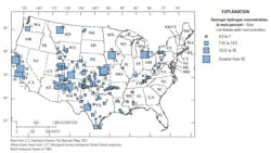
Within the US, hydrogen has recently been reported in Arizona, California, Kansas, Montana, and Nebraska. Observations of hydrogen in concentrations of more than 0.5 mol% are shown in Fig. 1, illustrating a general scattering of hydrogen occurrences throughout the US.
Particularly high concentrations have been found in the midcontinent region, around the Four Corners area (Arizona, Colorado, New Mexico, and Utah), and along the coast of California. But little has been published on establishing the controls on the locations of these occurrences and thus, predictability remains low.
To facilitate continued exploration of this new potential energy resource, research into ways to identify regions that may be favorable for hydrogen exploration is underway. The 2021 publication of a radiolytic production rate map for Australia delivered the first regional-scale map depicting relative favorability for hydrogen throughout that country.6 That map, however, relied heavily on surface geology extrapolated to a depth 1 km, which may be of limited utility due to lithologic heterogeneity along such distances, and the map did not fully integrate the spatial distribution of hydrogen generation sources with other potential factors, such as reservoir or seal potential.
In particular, the use of geophysical potential fields data may provide an understanding of geology at depths greater than 1 km. Considering several additional sources of hydrogen generation and integrating a variety of surface and subsurface datasets, the report underlying this article presents the first publicly available map of geologic hydrogen prospectivity for the conterminous US.
Results
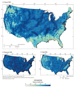
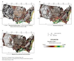
Fig. 2a shows the potential for a viable hydrogen source as a chance of sufficiency (COS) map. The map illustrates North American craton’s important role in providing a general source of old (Archean and Proterozoic) granitoids in the central part of the US that are potential sources of radiolytic hydrogen. Overall, the highest COS regions for hydrogen sources occur where serpentinization sources (mapped surface or subsurface ultramafic rocks) coincide with the North American craton, thus providing multiple possible hydrogen generation mechanisms. Examples of these areas include southern Oklahoma and the Texas Panhandle (the southern Oklahoma aulacogen), and northeastern Kansas, southeastern Nebraska, west-central Iowa, eastern Minnesota, and Michigan (the midcontinent rift). A few high COS source regions that do not overly the North American craton include the coast of central and northern California, which contain ophiolite sequences, and the Salton Sea area of southeastern California and southwestern Arizona.
The source COS map is particularly important for exploration efforts that focus on capturing actively seeping or migrating hydrogen, or for stimulated hydrogen generation,8 since reservoirs and seals are unnecessary in those scenarios.9 Figs. 2b and 2c show the reservoir and seal COS maps, respectively.
Both primary components, which are mapped on the continental scale, mainly depend on the occurrence of sedimentary strata. Although fractured crystalline (igneous and metamorphic) rocks may be locally porous, reservoirs are assigned a higher COS when sedimentary rocks are present in the subsurface because sedimentary rocks typically exhibit higher porosity and more predictable permeability.
In general, although reservoir quality is critically important for the development of fields and placement of wells, the authors do not view reservoir quality as particularly risky on the continental or play scale, which are focused on regions of high prospectivity but not the specific placement of wells. The seal component is viewed as generally riskier than the reservoir component but follows similar logic and the map is created using similar underlying data.
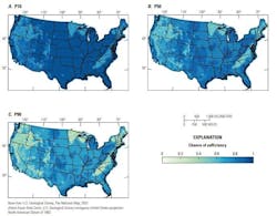
Hydrogen is more diffusive than methane and heavier hydrocarbons, and competent seals are critical for retaining subsurface accumulations (Maiga and others, 2024).5 A stochastic uncertainty analysis was performed, varying the COS of the primary components and their underlying subcomponents, which generally results in a bulk shift to higher or lower COS for the composite map with only small variations from region to region (Fig. 3).
Fig. 4 shows the final median (P50) hydrogen prospectivity map of the conterminous US. Reflecting the significant uncertainty remaining in subsurface hydrogen potential, there are no areas in the US with a COS of either 1 (100% certain sufficiency) or 0 (100% certain insufficiency). Instead, values range from 0.15 to 0.85, with a mean of 0.54. A COS of 0.5 generally indicates equal chances of sufficiency and insufficiency and, like a coin flip, indicates little or no preferential weight in either outcome.
COS values are generally higher than 0.5 in the region of the North American craton that contains sedimentary subsurface rocks. Overall, the highest COS values for hydrogen prospectivity occur in Michigan; parts of Kansas; north Texas; southern Oklahoma; on the western side of Williston basin in North Dakota and eastern Montana; and near the Four Corners region of Arizona, Utah, Colorado, and New Mexico. Additionally, the region intersecting western Kentucky and southern Illinois overlies the New Madrid seismic zone, the ancient Reelfoot rift, and a mineralized fluorspar district associated with serpentinized ultramafic intrusions of Permian age and has hydrogen prospectivity values reaching 0.85.10
Discussion
Recent exploration in the US has focused on the region of the midcontinent rift in Kansas, Nebraska, and Iowa. A four-way, structurally elevated closure exists at the basement level called the Nemaha High where high concentrations of hydrogen were observed in several wells in the 1980s through the early 2000s. Previous studies concluded that the hydrogen in these wells was sourced from kimberlites west of the feature or from iron oxidation within the underlying fractured Archean and Proterozoic basement. 11 12
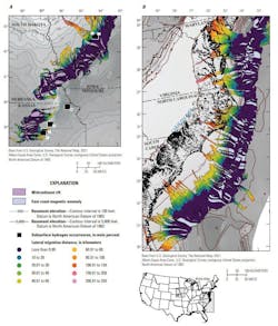
The authors' analysis also supports the alternative hypotheses that hydrogen originates from the serpentinization of deep-seated, ultramafic rocks in the core of the midcontinent rift or from the migration of deep-sourced hydrogen along the rift border faults. In either of these scenarios, migration pathways generated using a basement structure map indicate that updip lateral migration focuses fluid flow directly from the midcontinent rift towards tested well locations (Fig. 5a).
High concentrations of hydrogen (96 mol% H2) also have been observed in the Hofmann #3 well in Iowa.13 This well is along the west flank of the midcontinent rift in an area where lateral migration flow lines converge before flowing updip to the northwest (Fig. 7).
The regions along the midcontinent rift, especially those where migration is focusing, are likely favorable for hydrogen and have some of the highest composite COS in the prospectivity analysis. Reliance on crystalline rocks for the reservoir and seal components, however, reduces prospectivity for accumulations in the farthest northern part of the midcontinent rift in Minnesota (Fig. 4).
Although hydrogen occurrences have been discovered in wells targeting other natural gases or fluids (for example, water, helium, and hydrocarbons), other detections have been made with soil gas surveys. Recently, high concentrations of hydrogen in soil gas have been observed in shallow, ellipsoidal surface depressions known colloquially as “fairy circles” or Carolina bays.14
These features have been theorized to be formed by processes as varied as impact craters; thermokarst lakes; or wind, wave, or groundwater processes. But their depth and aspect ratio preclude compatibility with impact craters and thermokarst lake processes.15
Although these features are not always associated with hydrogen degassing, a correlation between these features and elevated surface hydrogen observations has been widely supported. Fluxes have been noted to vary rapidly throughout daily cycles.16 The mechanism underlying the association has not been thoroughly established, although shallow transport models have sought to explain their periodicity.17
In the US, Carolina bays occur in some parts of Nebraska (known locally as the Nebraska “rainwater basins” or in Kansas as playa-lunette systems) and extensively along the eastern seaboard.15 The eastern seaboard of the US is a passive margin created during the rifting of Pangea. Globally, many rifted margins are associated with serpentinized mantle, and previous researchers have hypothesized that exhumed or otherwise serpentinized mantle rocks may exist offshore at depth along the eastern seaboard of the US.18
The authors used the East Coast Magnetic Anomaly (ECMA) to delineate the rifted edge of continental crust and propose it as a potential spatial proxy for a source of subsurface hydrogen due to serpentinization. Fig. 5b shows lateral migration flow pathways from this potential source and indicates flow updip from offshore to onshore.
Many flow lines, and the drainage areas that encapsulate them (Fig. 6), overlie the region of Carolina bays in the US, from northern Florida to southern New Jersey.15 North of the Baltimore Canyon Trough, a major basement depression off the coast of New Jersey,19 flow is redirected outboard, rather than inboard; this transition coincides with the disappearance of Carolina bays in the northeastern States.
The authors hypothesize that Carolina bays, with sporadic hydrogen degassing, may represent the far inboard surface seepage of hydrogen that has migrated long-distance from deep, offshore serpentinized mantle-derived source rocks. If this is true, subsurface reservoirs may contain hydrogen that was trapped along this route near the coastline and offshore.
Accordingly, relative increases in COS are shown in the prospectivity map, particularly along the coast of North Carolina, eastern Maryland, Delaware, and southern New Jersey, where the ECMA is particularly close to the shoreline (Figs. 6-8).
This hypothesis can be further tested by examining subsurface stratigraphic relations from offshore to onshore to characterize potential carrier beds with sufficient porosity and permeability to facilitate this migration.
For additional information, the complete prospectivity map, paper, and data are available.
References
- I. Ellis, G.S. and Gelman, S.E., “Model predictions of global geologic hydrogen sources,” Science Advances, Vol. 10, No. 50, Dec. 13, 2024.
- Zgonnik, V., “The occurrence and geoscience of natural hydrogen—A comprehensive view,” Earth Science Reviews, Vol. 203, Article 103140, 2020, p. 51.
- Prinzhofer, A., Tahara Cisse, C.S., and Diallo, A.B., “Discovery of large accumulation of natural hydrogen in Bourakebougou (Mali),” International Journal of Hydrogen Energy, Vol. 43, No. 42, 2018, pp. 19315-19326.
- Maiga, O., Deville, E., Laval, J., Prinzhofer, A., and Diallo, A.B., “Characterization of spontaneously recharging natural hydrogen reservoirs of Bourakebougou in Mali,” Scientific Reports, Vol. 13, Article, 11876, 2023, p. 13.
- Maiga, O., Deville, E., Laval, J., Prinzhofer, A., and Diallo, A.B., “Trapping processes of large volumes of natural hydrogen in the subsurface—The emblematic case of Bourakebougou H2 field in Mali,” International Journal of Hydrogen Energy, Vol. 50, Part B, 2024, pp. 640-647.
- Boreham, C.J., Edwards, D.S., Czado, K., Rollet, N., Wang, L., van der Wielen, S., Champion, D., Blewett, R., Feitz, A., and Henson, P.A., “Hydrogen in Australian natural gas—Occurrences, sources, and resources,” The APPEA Journal, Vol. 61, No. 1, 2021, pp. 163-191.
- Milkov, A., “Molecular hydrogen in surface and subsurface natural gases—Abundance, origin, and ideas for deliberate exploration,” Earth-Science Reviews, Vol. 230, Article 104063, 2022, p. 27.
- Osselin, F., Soulaine, C., Fauguerolles, C., Gaucher, E.C., Scaillet, B., and Pichavant, M., “Orange hydrogen is the new green,” Nature Geoscience, Vol. 15, No. 10, 2022, pp. 765-769.
- Prinzhofer, A. and Cacas-Stentz, M.-C., “Natural hydrogen and blend gas—A dynamic model of accumulation,” International Journal of Hydrogen Energy, Vol. 48, No. 57, 2023, pp. 21610-21623.
- Smith-Schmitz, S.E. and Appold, M.S., “Reactive transport modelling of the role of fluorine-rich groundwater in the formation of fluorite ore deposits in the Illinois-Kentucky District, USA,” Hydrogeology Journal, Vol. 30, 2022, pp. 1199-1218.
- Coveney, R.M., Jr., Goebel, E.D., Zeller, E.J., Dreschhoff, G.A.M., Angino, E.E., “Serpentinization and the origin of hydrogen gas in Kansas,” AAPG Bulletin, Vol. 71, No. 1, January 1987, pp. 39-48.
- Guélard, J., Beaumont, V., Rouchon, V., Guyot, F., Pillot, D., Jézéquel, D., Ader, M., Newell, K.D., and Deville, E., “Natural H2 in Kansas—Deep or Shallow Origin?,” Geochemistry, Geophysics, Geosystems, Vol. 18, No. 5, May 2017, pp. 1841-1865.
- Moore, B.J. and Sigler, S., “Analysis of natural gases,” Bureau of Mines Information Circular, US Department of Energy, Office of Scientific and Technical Information, Jan. 1, 1987, p. 74.
- Zgonnik, V., Beaumont, V., Deville, E., Larin, N., Pillot, D., and Farrell, K.M., “Evidence for natural molecular hydrogen seepage associated with Carolina Bays (surficial, ovoid depressions on the Atlantic coastal plain, province of the USA),” Progress in Earth and Planetary Science, Vol. 2, Article 31, Oct. 9, 2015, p. 15.
- Lundine, M.A. and Trembanis, A.C., “Using convolutional neural networks for detection and morphometric analysis of Carolina Bays from publicly available digital elevation models,” Remote Sensing, Vol. 13, No. 18, Article 3770, Sept. 20, 2021, p. 27.
- Moretti, I., Prinzhofer, A., Françolin, J., Pacheco, C., Rosanne, M., Rupin, F., and Mertens, J., “Long-term monitoring of natural hydrogen superficial emissions in a Brazilian cratonic environment—Sporadic large pulses versus daily periodic emissions,” International Journal of Hydrogen Energy, Vol. 46, No. 5, Jan. 19, 2021, pp. 3615-3628.
- Myagkiy, A., Moretti, I., and Brunet. F., “Space and time distribution of subsurface H2 concentration in so-called “fairy circles”—Insight from a conceptual 2-D transport model,” BGSF Earth Sciences Bulletin, Vol. 191, Article 13, June 5, 2020, p. 13.
- Biari, Y., Klingelhoefer, F., Sahabi, M., Funck, T., Benabdellouahed, M., Schnabel, M., Reichert, C., Gutscher, M.-A., Bronner, A., and Austin, J.A., “Opening of the central Atlantic Ocean—Implications for geometric rifting and symmetric initial seafloor spreading after continental breakup,” Tectonics, Vol. 36, No. 6, June 10, 2017, pp. 1129-1150.
- Grow, J.A., Klitgord, K.D., and Schlee, J.S., “Structure and evolution of Baltimore Canyon Trough,” in Sheridan, R.E. and Grow, J.A., “The Atlantic continental margin—US,” The Geological Society of America, Vol. 1-2, 1988, pp. 269-290.
