Deepwater Taranaki basin: Exploring a New Zealand frontier
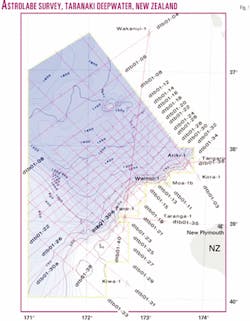
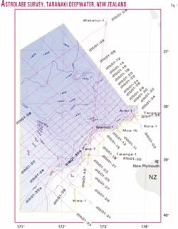
During 2001, TGS-Nopec Geophysical Co. acquired the 6,200-km Astrolabe 2D seismic survey over the deepwater Taranaki basin, the extension of the basin from the shelf edge to the 2,000-m isobath.
This article presents the results of that reconnaissance survey, namely:
- The deepwater Taranaki is a Cretaceous play, different from traditional (Kapuni) shallower-water plays on the shelf.
- The coarse Astrolabe grid (10 or 20 km) has established thick sedimentary successions (up to 10 km).
- Large traps (200 sq km) have been identified.
- Taranaki shelf wells have established source and reservoir facies for the deepwater areas.
Introduction
The Taranaki basin, currently New Zealand's only producing basin, has not previously been explored for any significant distance beyond the shelf edge.
A small volume of industry seismic data was acquired from the region in the 1970s and the New Zealand government acquired a single-channel seismic survey in 1989.
In 1997, the Rig Seismic vessel acquired a single 1,000-km seismic line along the axis of the New Caledonia basin from the Wainui-1 well on the Taranaki shelf edge to the DSDP-206 drillsite. Thick Cretaceous sediments characterize the deepwater Taranaki sector of this line.
In 2001, TGS-Nopec in collaboration with the Institute of Geological & Nuclear Sciences (GNS) acquired 6,200 km of new nonexclusive 2D data in the deepwater Taranaki basin (Fig. 1). The survey also tied eight wells on the shelf and the deepwater Wakanui-1 well in the adjacent Northland basin.
TGS-Nopec and GNS planned the 2D reconnaissance survey of the deepwater Taranaki basin on a basic 10-km grid. In more than 1,500 m of water and in the southern sector of the area the grid is much wider. In the latter region, known sedimentary section amounts to only 2 sec or so, although a thicker section is suspected to lie below a volcanic layer.
Basin development
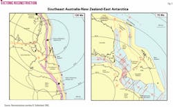
Geological development began with formation of Late Cretaceous rift basins associated with breakup of East Gondwana (Fig. 2).
Early Cretaceous synrift sediments formed in response to movements, which ultimately led to the separation of Australia, East Antarctica, the Lord Howe Rise, and the continental blocks of the New Zealand region collectively known as the "New Zealand mini-continent." Many source rocks were deposited at that time in coal basins, particularly in the Taranaki region.1
Tasman Sea rifting commenced at around 90 Ma with the oldest oceanic crust formed around 85 Ma.2 From this time the whole of the Taranaki basin developed as part of the New Zealand region.
Following rifting and ocean spreading, the New Zealand landmass gradually subsided, until, in the Oligocene, very little remained above sea level. Consequently, New Zealand's sedimentary record, though complete through the Paleogene, is generally very thin. However, rich potential source rocks were deposited around the New Zealand region during the Paleogene, as were reservoir units for the major Taranaki fields such as Maui, Kapuni, and Pohokura.
The present plate boundary was initiated at the end of the Paleogene and is complex. It includes southwestward subduction of the Pacific Plate below North Island, northeastward subduction of the Australian Plate below the southern end of South Island, and a 600 km long strike-slip boundary offsetting the two trenches and causing gradual convergence of the two systems.
Abundant sealing mudstone, reservoir sandstones, and limestones of many facies were deposited during the Neogene. In addition, the complex tectonics of the developing plate boundary formed many structures capable of receiving charge from the maturing source rocks.
Astrolabe data
The Astrolabe survey has revealed the presence of thick sedimentary section in the deeper water off the shelf and shown a new Cretaceous play for the Taranaki basin (Fig. 3).
A mainly Late Cretaceous delta is mapped, prograding into the head of the New Caledonia basin. The delta, in common with many deltas around the world, is believed to contain large volumes of petroleum source rocks, culminating with deposition of the Rakopi formation coal measures.
Deltaic deposition was terminated by a major marine transgression that shifted the facies belts at least 100 km to the southeast. This maximum flooding surface represents a condensed section of the sort that commonly is an excellent regional seal. This regional seal overlies rocks interpreted to be coal measures from well ties and seismic character.
A thin Oligocene limestone marks the onset of regression accompanying development of the present plate boundary and represents a final maximum flooding surface. All of these flooding surfaces may be good regional seals facilitating formation of petroleum traps at multiple levels.
The Astrolabe survey further reveals a total sediment thickness of more than 10,000 m in parts of the survey area. Relative ages and character of the sedimentary fill, together with considerations of basin and reflector geometry, allow comparisons with the productive Gippsland basin of Southeast Australia.
Sequence stratigraphy
The basal unit of the Cretaceous section is a mounded but otherwise characterless unit that is poorly imaged.
Above this unit is a sequence prograding apparently to the northwest, away from the New Zealand landmass and along the axis of the New Caledonia basin. The topset unit of the later part of the sequence consists of high amplitude, blocky, and discontinuous reflectors typical of coaly facies seen elsewhere in Taranaki. The prograding unit is interpreted here as a delta 100 km long and 2,000 m thick (Fig. 3).
Seawards of the delta are deeper water sediments that may contain black shales. Overlying the early delta are thin-shingled units (Fig. 5) that may have recorded episodic rapid transgressions that forced the delta to build from farther to the southeast. A second transgression eventually truncated the new delta, leaving only the delta-front sands in place. These rapid transgressions may have been tectonic in origin.
The remaining Late Cretaceous section is the thick lateral equivalent of the thin unit tested by the Wainui-1 well. A marine influence was suggested for the Late Cretaceous, coal-measure sediments in the well.3
The recognition of turbidite fans within the latest Cretaceous of the deepwater Taranaki basin gives confidence in the interpretation of this unit as a marine succession.
In many basins surrounding New Zealand, black marine shale of Paleocene age is recognized. In particular, it has been recognized and mapped in the adjacent Northland basin.4 It is highly likely that it is present also in the deepwater Taranaki basin.
Where this unit is mature, it may be expelling oil to be trapped in possible overlying sandstones of Eocene age. These marine equivalents of the Kapuni Group form the reservoirs for Kapuni field and giant Maui field that have been the mainstay of the New Zealand petroleum industry for many years.
Petroleum systems
Two possible petroleum systems are postulated. The older is the Late Cretaceous system sourced by the early delta and its possible offshore time-equivalent black shales. Petroleum was generated from these sources in the center of the basin during the latest Cretaceous and Paleogene.
Near the flanks of the basin, where crustal thicknesses are greater, heat flow is lower and the units may be shallower, generation and expulsion would have been delayed. Reservoirs are expected to be Late Cretaceous turbidite fans or possibly shoreface or delta front sands. At least one turbidite mound displays a high amplitude seismic anomaly.
In the younger of the two petroleum systems, the Paleogene system, petroleum may have been generated from the Paleocene black shale to migrate into the overlying Eocene sands. These are also expected to be turbidite fans, the seaward equivalents of the terrestrial Kapuni reservoirs of nearshore Taranaki. Some evidence is emerging of minor inversion, possible in the Eocene. This event may have provided a late heat pulse that may have brought more of the system into the oil window.
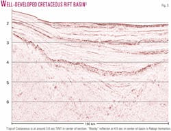
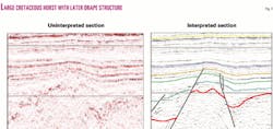
Trapping mechanisms include drapes across rift block highs (Fig. 4) and inversion structures created by gentle compression and, possibly, strike-slip faulting during the Eocene. Large structures with areas of 50 to 150 sq km are present in the survey area.
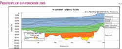
Thermal modeling shows that source rocks within the delta are generally mature today and that maturity is a low risk for this basin. Two-dimensional thermal maturity modeling predicts there is up to 1,000 m of mid-Cretaceous source rock in the oil expulsion window (Fig. 5) and that:
- The present-day oil generation window is below about 2,800 m below sea floor (bsf) for marine source rocks (Type II kinetics) and 3,200 m for nonmarine source rocks (Type III kinetics). The present-day gas window is below about 5,000 m bsf for nonmarine source rocks (Type III kinetics).
In the center of the basin, most oil expulsion occurred in the Cretaceous and Paleogene. A post-Miocene pulse of sedimentation resulted in the top of the oil expulsion window climbing a further 200 m to reach the base of Rakopi formation equivalent at the present day.
Oil or gas?
Following the discovery of onshore Kapuni gas-condensate field in the 1950s and giant Maui gas-condensate field in the 1970s, the industry tended to the belief that Taranaki is gas-prone and it has therefore not been a popular exploration venue. Several lines of evidence suggest that the deepwater Taranaki basin should be oil-prone rather than gas-prone.
The first is that the shallow water and onshore Taranaki basin is now seen as more oil-prone than previously. This is due to an oil trend in the onshore overthrust zone, Kaimiro and Ngatoro oilfields in northern onshore Taranaki, the Maari discovery in 1999, and the more recent Rimu discovery in 2000, together with the recent offshore discoveries of an oil leg in Maui field and a better understanding of its charge history.
Maui hydrocarbons have a terrestrial source (predominantly Late Cretaceous coal and coaly sediments) and complex charge history.5 6 Earliest charge was hot brines with high carbon dioxide content, followed by several phases of oil migration and a latest phase of oil and gas charge.5
The second line of reasoning is based on the seismic stratigraphy outlined above. The increased marine influence implied by the delta interpretation and the known oil-proneness of deltas around the world increases confidence that the deepwater Taranaki basin is oil prone. In addition, the inferred restricted seaway increases the chances of widespread organic rich shales being deposited.
References
- King, P.R., and Thrasher, G.P., "Cretaceous-Cenozoic geology and petroleum systems of the Taranaki basin, New Zealand," Institute of Geological & Nuclear Sciences Monograph 13, IGNS, Lower Hutt, 1996, 243 pp. and six enclosures.
- Norvick, M.S., Smith, M.A., and Power, M.R., "The plate tectonic evolution of eastern Australasia guided by the stratigraphy of the Gippsland basin," Eastern Australia Basins Symposium, Melbourne, November 2001, pp. 15-24.
- Shell, BP, and Todd, "Well completion report, Wainui-1," unpub. open-file petroleum report 869. Ministry of Economic Development, Wellington, 1982.
- Isaac, M.J., Herzer, R.H., Brook, F.J., and Hayward, B.W., "Cretaceous and Cenozoic sedimentary basins of Northland, New Zealand," Institute of Geological & Nuclear Sciences Monograph 8, IGNS, Lower Hutt, 1994, 203 pp. and four sheets.
- Funnell, R.H., Stagpoole, V.M., Nichol, A., Killops, S.D., Reyes, A.G., and Darby, D., "Migration of oil and gas into the Maui Field, Taranaki Basin, New Zealand," Eastern Australia Basins Symposium, Melbourne, November 2001, pp. 121-128.
- Sykes, R., "Depositional and rank controls on the petroleum potential of coaly source rocks," Eastern Australia Basins Symposium, Melbourne, November 2001, pp. 591-602.
The authors
Chris Uruski ([email protected]) moved from Wales to New Zealand in 1987 and has been employed since then as a seismic interpreter at the New Zealand Geological Survey, now GNS. Before that he served in the Royal Navy, as a marine geologist and geophysicist at Aberystwyth and Durham universities, and as a consultant in the oil industry. He was graduated in geology from University College of Wales.
Vaughan Stagpoole is a geophysicist with the Institute of Geological & Nuclear Sciences Ltd. He uses geophysical and geological data to understand tectonic processes involved in the formation and development of sedimentary basins. He specializes in modeling heat flow, hydrocarbon generation, and fluid flow in sedimentary basins and studies volcanic and geothermal processes. He holds a BSc (Hons.) and PhD from Victoria University.
Peter Baillie ([email protected]) joined TGS-Nopec Geophysical Co. in 1997 and is chief geologist Asia Pacific. He is editor of the Journal of the Petroleum Exploration Society of Australia (PESA). He is a graduate of the University of Tasmania and Macquarie University.
