ARMENIA'S PROSPECTS-2: Hydrocarbon potential listed for Armenia's main basins
Armenia appears to have oil or gas potential in areas that have received limited study as well as areas that have received no study.
The first part of this article described the regional geologic setting and the results of two exploration periods (OGJ, Aug. 12, 2002, p. 36). This concluding second part summarizes the potential of the main basins, results of recent exploration, and the fiscal system.
Near Yerevan basin
The Garni-Shorakhpur area (Fig. 5) is the most prospective part of the Near Yerevan basin.
The dominant tectonic feature is the northeast trending left-lateral strike slip Azat fault system. This is a semi-regional fault that separates a highly uplifted and eroded mountainous area to the southeast from a less uplifted area to the northwest.
The main leads and prospects lie north of the fault, one of these being tested by the recent Azat-1 well. This area is of interest because of the oil recovered from Shorakhpur-1P and extensive oil shows recorded in Garni-1G. Fig. 3 in Part 1 summarizes the stratigraphy.
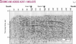
A N-S seismic line (Fig. 7) passes through Azat-1 and Garni-1. Extensive oil shows seen intermittently in the 350-950 m interval in Garni-1 were not apparent in Azat-1. A detailed gravity survey carried out in 1998 indicated the presence of a subtle wrench fault close to Garni-1 that might provide an explanation for the discrepancy. The oil seep perhaps came from the deep Cretaceous oil source seen in the Azat-1 well.
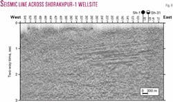
On a W-E seismic line (Fig. 8) that passes through Shorakhpur-1, a deep thrust can be seen at approximately 2.5 sec in the east which then rises gradually westwards.
Reservoir objectives: The principal reservoir objectives are Middle Eocene fractured tuffs and Paleocene fractured carbonates. The Middle Eocene is an objective across the region, representing a proven play in the Georgia Republic, north of Armenia.
Middle Eocene fractured tuffs form the principal reservoir in several oil fields in the Kura basin of the Georgia Republic, the largest being Samgori, which has produced 166 million bbl. In Azat-1, large subvertical open fractures are clearly visible on Western Atlas's patented Star tool log, but unfortunately they were water bearing.
The Paleocene is of interest because it was from carbonates at the Paleocene-Eocene boundary that oil was recovered in Shorakhpur-1P. The Paleocene carbonates are thought to be turbidites that contain reworked carbonate grains eroded from earlier carbonate deposits. It is expected that fracture type porosity will be developed, although other secondary forms of porosity such as vugs may also occur. At a deeper level, bitumen was extracted from Upper Cretaceous drill cuttings in Azat-1.
Source: The oil from Shorakhpur-1P is of medium gravity (originally 33° gravity) and moderate viscosity, with low sulfur content. The oil has been generated from a source rock of Tertiary or late Cretaceous age. That source rock would have contained mainly terrestrial, waxy, organic type matter and was in the middle part of the main oil generation window. Possible source rocks include shales from the Upper Eocene/Oligocene, Middle Eocene, and Paleocene/Cretaceous. Total organic carbon of some intervals is between 1 and 2%.
Migrant hydrocarbons have been clearly identified from cuttings from an Upper Cretaceous interval (at over 3,200 m) in Azat-1. These appear to have been generated at a modest level of maturity from a carbonate source rock. This oil is not generated by the same source as in Shorakhpur-1P, which was generated by a clastic source rock.
Seal: Potential seals are present within the prospective section. These include Upper Eocene claystones and Lower Eocene marls.
Trap: The Garni-Shorakhpur area contains two main prospects (Fig. 5). The prospects have been developed from interpreting old and new seismic sections and integrating satellite data. The majority of the traps as mapped at present are fault related, although folding also plays a role. The faults mapped at surface appear to be strike-slip faults, but at depth it may be that thrust faulting with considerable horizontal displacement has also occurred.
Reserves: Recent studies suggest that the Shorakhpur and Nubarashen prospects could each contain about 20 million bbl of recoverable oil.
Oktemberyan basin
The Oktemberyan basin is the most western subdivision of the Ararat intermontane depression in Armenia. It has been a focus of interest because well Oktemberyan-13E flowed methane on test for 6 months.
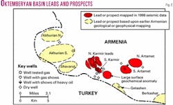
Other wells flowed small amounts of gas or had gas shows while drilling. One well had a heavy oil show. The presently recognized leads and prospects and key wells are illustrated in Fig. 6; the stratigraphy is summarized in Fig. 4 in Part 1.
Reservoir objectives: These include Oligocene sandstones of the Lower Multicolored and Oktemberyan suites. These sandstones are believed to be deltaic type sands and include a significant lithic component. Little core information is present, but what is available suggests porosities of 15% and permeabilities of 9 md. Deeper potential is thought to exist in fractured Middle Eocene carbonates.
Source: The reservoir objectives are interbedded with claystones with total organic carbon values as high as 3.45%. However, locally generated hydrocarbon extract data suggest they are immature. It is likely that much of the observed gas has been sourced at depth from more mature sediments from beneath the ophiolite, which forms a floor to the Tertiary sediments in the basin.
Seal: The prospective section is overlain by the thick Clay Subsuite of the Oktemberyan Suite. Other thick claystones are interbedded with the reservoir objectives, and these may provide intraformational seals.
Trap: The basin contains several leads and prospects (Fig. 6). The basin is inverted, experiencing uplift and structuring in the Pliocene and probably earlier times.
In places a highly faulted allochthonous sequence overlies deeper autochthonous fault blocks. Gas tested thus far in wells Oktemberyan-13E and 7P has come from the allochthonous sequence; no conclusive tests of gas shows in the underlying autochthonous sequence have yet been made.
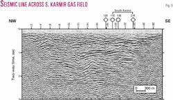
A seismic strike line (Fig. 9) passing through one gas prospect shows a division between allochthonous and autochthonous fault blocks at approximately 1.2 sec directly beneath the South Karmir wells.
Reserves: Three prospects have been recognized primarily by the 1997-98 acquired seismic data and have "most likely" sizes ranging from 10 to 50 bcf of recoverable gas, respectively. In addition, there is a fourth lead over which a major surface geochemical anomaly occurs (using a microbial technique), but this has not yet been defined seismically. Leads recognized earlier by Armenian experts and the 1995 Tacis study have yet to be detailed.
Recent exploration
Following from the initial Tacis project, there was a second project assisting government efforts to find oil and gas investors. In due course, this resulted in the eventual signing in January 1997 of a production-sharing agreement (PSA) between the Ministry of Energy and the Armenian American Exploration Co. (AAEC) from San Diego, Calif.
AAEC committed to a three-well program and 60 km of seismic, all to be completed within 1 year, and a minimum expenditure of $10 million. The program itself, given the large size of the concession, was reasonable and fair but the time period for achieving it proved to be unrealistic.
During July 1997 to March 1998 AAEC recorded 210 km of reflection seismic data using an Armenian seismic contractor, Atom Energy Seismic Projects. In August 1997 AAEC purchased a Skytop Brewster drilling rig in France and had it shipped via the Black Sea, arriving in October.
AAEC set up its own camp, and drilling of the Azat-1 exploration well commenced in December. By July 1998 the well had reached 3,524 m, having encountered minor oil traces. By this time over $20 million had been spent.
Mainly for financial reasons, drilling ceased while technical studies continued. AAEC relinquished the northern part of the license (Block 1) in February 2002 and retained the southern Block 2 (7,250 sq km) until February 2004. The Ministry of Energy released AAEC from its remaining work obligations. AAEC is seeking new investment partners.
AAEC has written or commissioned over 50 studies, many during the last 3 years. In-house Armenian experts have carried out extensive seismic reprocessing of both recent and old seismic data. This work, together with extensive reviews of geochemical, reservoir, and other data, has led to an improved understanding of the hydrocarbon potential, together with a better appreciation of the risks involved.
Other potential
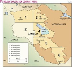
There remains hydrocarbon potential in other parts of Armenia that so far have had little serious study (Fig. 10). For instance:
- There were reports of releases of gas during the 1988 Spitak earthquake in that region.
- Permian-age organic rich, mature, oil- and gas-prone calcareous shales and mudstones are present largely in southeastern Armenia (there is an unsubstantiated report of an oil show in the Meghri area).
- An oil seep at the Yeranos borehole, southeast of Lake Sevan, is still active.
- Medium/light oil was recovered from drilling muds in the Mid-Jurassic of the Ahkakhlu-3 borehole in the Idzhevan coal field area.
- Heavy, waxy, asphaltic residual oil was found in Triassic coals in the Ghermanis-4 borehole west of Yeghegnadzor.
As stated above, recent studies suggest that the two oil prospects, Shorakhpur and Nubarashen, east of Yerevan, contain potential recoverable volumes of 20 million bbl each. Over 10 years the two fields could produce a combined 11,000 b/d of oil, about equal to the current daily consumption of petroleum products (gasoline, diesel, kerosene, etc.) in Armenia.
Other fields could exist, particularly northwards into the deep Aramus basin, which is believed to be the main oil generating source area.
The four gas prospects identified in southwestern Armavir have sizes of 10 to 40 bcf of recoverable gas. Statistically these are "most likely" estimates; actual reserves could be much greater. At least another eight similar size (or larger) prospects are known but require more technical work.
A reasonable estimate of gas potential so far is 500 bcf or greater, which represents a 10-year supply for Armenia as imports stand at 50 bcf/year. The northern and eastern Oktemberyan basin remains largely unexplored and would be expected to yield further deposits.
Fiscal considerations
Title to hydrocarbons in the ground in Armenia, as is common with most other states, is vested in the republic.
The government granted the Ministry of Energy a sole mandate to act in respect of petroleum matters. Within the ministry, the sole contact body designated to act upon petroleum matters is Geoenergy closed joint stock company (cjsc).
There is no bar to foreign equity involvement in the upstream or downstream ends of the petroleum sector. As stated previously, in January 1997 a PSA was concluded with AAEC. Applications by interested companies for any exploration license area can be made at any time.
In the energy sector, the Code of Underground Resources, enacted by Parliament in 1992, has broad enabling principles that allow foreign investment to take place. The Code of Foreign Investment is also important to potential foreign investors. Both laws are fully consistent with the Armenian government's investment objectives.
Geoenergy is preparing a draft Petroleum Law that it hopes to submit later this year to the National Assembly.
All current agreements have to be approved by the government. As stated earlier, under the EU-funded Tacis program of 1994-95, a model petroleum agreement was drafted which serves as the basis for all negotiations with IOCs. Some of the terms and conditions contained within this agreement are:
- Negotiable exploratory work programs and financial commitments;
- Negotiable exploration periods and relinquishment terms;
- A Technical Advisory Committee comprising staff of the IOC and the Ministry;
- Independent, international sole expert and arbitration resolution in disputes;
- The usual provisions as to appraisal and development of a discovery for both oil and gas;
- Any developed oil and gas can be freely exported;
- Negotiable levels of cost petroleum and profit petroleum splits;
- Standard international provisions for the protection of the environment and for adherence to standards of good oilfield practice;
- IOC rights assignment;
- No foreign exchange controls;
- Standard international accounting provisions.
Six contract areas have been defined, five of which are available for licensing (Fig. 10). They are: Block 1 (open; 5,450 sq km); Block 2 (AAEC; 7,250 sq km); Block 3 (open; 3,325 sq km); Block 4 (open; 5,925 sq km); Block 5 (open: 4,250 sq km); Block 6 (open; 3,600 sq km).
The government and its advisers believe that the draft model production-sharing agreement is entirely consistent with good international practice. Government will entertain negotiations around other contractual arrangements provided they are consistent with international practice and the government's objectives.
Bibliography
AAEC, numerous internal reports.
Tacis report, "Evaluation of Armenia's Potential Hydrocarbon Deposit," July 1995.
Wheaton, J.R., et al., "Energy-starved Armenia has promising geology but big transport challenges," OGJ, May 22, 1995, p. 40.
The authors
Tim Papworth ([email protected]) is a UK-based petroleum exploration consultant with over 30 years' experience in areas including the North Sea, onshore UK, Libya, Egypt, Tunisia, Malaysia, Gabon, Namibia, Georgia Republic, and Russia. He has worked intermittently in Armenia since 1994, initiated operations for AAEC in April 1997, and is general manager of AAEC's Yerevan office.
Dr. Andranik Aghabalyan ([email protected]) is a mining engineer with nearly 20 years' experience in the economic evaluation of mineral deposits. Since 1992 he has been responsible on behalf of the Armenian Ministry of Energy for managing activities in the geological study, development, and utilization of solid fuel (coal, oil shale, peat), hydrocarbons and geothermal resources. He is director general of Geoenergy cjsc.


