NEW MEXICO ELEVATOR BASINS-1: Petroleum systems studied in southern ancestral Rocky Mountains
The Tucumcari, Estancia, Carrizozo, and Vaughn basins are in northeast and central New Mexico. These basins began to form during the Atokan (Early Pennsylvanian) and saw continued tectonic development through the Wolfcampian (Early Permian). They are tectonic elements of the southern ancestral Rocky Mountains and were formed along the flanks of the late Paleozoic Sierra Grande and Pedernal uplifts in a strike-slip setting. During the late Paleozoic, Precambrian cores of these uplifts were exposed and were the source of sediments deposited in adjoining basins. Along the boundaries of adjoining uplifts, however, these basins have component elevator basins.
Elevator basins are long, narrow, and structurally deep troughs bounded by high-angle faults. They are either elongate parallel to the axes of the adjoining uplifts and separate the uplifts from areas of shelf deposition or they cut into the flanks of these uplifts. Bounding faults of Early Pennsylvanian to Early Permian age have vertical offsets that can exceed 5,000 ft. Basin width can be 5-15 miles, and basin length can be 20-50 miles.
Early to Late Pennsylvanian strata in these elevator basins contain mature petroleum source rocks. Deposition was dominated by shales and sandstones derived from erosion of Precambrian rocks exposed on the adjacent uplifts. Total organic carbon (TOC) can exceed 9% in black basin-fill shales. Kerogens range from gas-prone woody types to oil-prone amorphous types.
Greater depth of burial in the elevator basins as compared to the adjoining uplifts and shelf areas has resulted in higher levels of thermal maturation in the basins. Shales in many of these elevator basins are in the oil window, and shales on the adjoining shelves are less mature.
Hydrocarbons generated in the basins may be trapped in basinal sandstones and may have also migrated upward along the bounding faults and into strata on the adjacent shelves and uplifts where the reservoirs may be either fringing reefs or arkosic sandstones.
Introduction
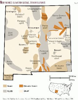
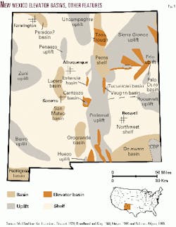
New Mexico was subdivided into a series of shelf areas, basins, and intervening uplifts during the Pennsylvanian and Permian (Fig. 1). The main uplifts in New Mexico were elements of the southern ancestral Rocky Mountains. The major uplifts include the north-south trending Pedernal uplift, the northeast-trending Sierra Grande uplift, and the Uncompaghre, Zuni, Burro, and Roosevelt uplifts. In the southeast, the Central Basin platform was an uplifted tectonic element that divided the Permian basin into the deep Delaware basin in New Mexico and the deep Midland basin in Texas.
The Tucumcari basin occupied east-central New Mexico and was mostly an area of shallow-marine to nonmarine deposition. The Frio uplift separated the Tucumcari basin from the Palo Duro basin of the Texas Panhandle. The Pecos shelf filled the gap between the Uncompaghre and Sierra Grande uplifts. In southwest New Mexico, the deep marine Pedregosa basin extended south into Mexico.
Ancestral Rocky Mountain uplifts and basins in New Mexico were formed primarily along regional shear zones which were activated during the Ouachita and Arbuckle orogenies.1 2 3
Elevator basins
Elevator basins are defined as long, narrow, and structurally deep troughs bounded by high-angle faults. They are typically 20-50 miles long and 5-15 miles wide. Bounding faults have vertical offsets that can exceed 5,000 ft.
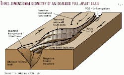
Many of these basins are elongate parallel to the axes of adjoining ancestral Rocky Mountains uplifts. They separate those uplifts from areas of shelf deposition. These elevator basins appear to be pull-apart structures formed along strike-slip faults of regional extent.4 Dooley and McClay5 and Nilsen and Sylvester6 have described the mechanism of formation of this type of elevator basin (Fig. 2). Some elevator basins are not parallel to the axes of the uplifts. These are oblique to uplifts and cut across the boundaries of the uplifts. The mechanism of formation of this type of basin is not well understood.
Although they appear to have been formed in a strike-slip setting,2 3 their geometry and orientation indicates they are not analogs to the pull-apart basins discussed by Doolley and McClay5 and Nilsen and Sylvester.6 Their exact mechanism of formation is enigmatic. For this reason, the term elevator basin is used instead of pull-apart basin to describe a family of basin types related by their overall geometry, internal depositional facies, distribution of source rock facies and source-rock maturity, and petroleum systems.
In north-central and west-central Texas, a series of pull-apart elevator basins and associated pop-up structures (uplifts) was formed by Early Pennsylvanian wrench faulting along the Matador arch.7 8 9 One basin has more than 10,000 ft of structural relief and contains more than 6,000 ft of Atokan (Early Pennsylvanian) and Lower Desmoinesian (Middle Pennsylvanian) sediments.
Kerogen-rich organic shales are mature source rocks of gas in the basin. Gas generated in these source rocks was trapped in Lower Pennsylvanian conglomerates. This trap forms Rhombochasm gas field.
This three-part article discusses elevator basins associated with the Tucumcari, Estancia, Carrizozo, and Vaughn basins.
Petroleum source rock data used in this report were obtained mostly from Broad- head10 11 and Broadhead et al.12 Some un- published source rock data were also used.
Tucumcari basin
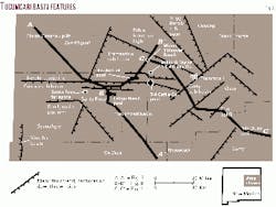
The Tucumcari basin of east-central New Mexico (Fig. 3) is an asymmetric structural depression that existed as a depositional basin from Atokan (Early Pennsylvanian) through Wolfcampian (Early Permian) time.13
The basin covers 5,000 sq miles. To the north and northwest, the Sierra Grande uplift separates the Tucumcari basin from the Pecos shelf of Baltz and Myers.14 To the northeast the Bravo dome separates the Tucumcari basin from the Dalhart basin of the Texas and Oklahoma panhandles. On the east, the Frio uplift15 separates the Tucumcari basin from the Palo Duro basin. To the south, the Tucumcari basin rises gently upward and merges with the Northwest shelf of the Permian Basin and the Roosevelt uplift (Matador arch of Texas terminology, Portales arch of Pitt11).
Deepest parts of the Tucumcari basin are in elevator basins along the northern margin of the basin in Guadalupe, San Miguel, and Quay counties. These are referred to as the Cuervo, Trementina, Trigg Ranch, and Quay sub-basins (Fig. 3). In these elevator basins, depth to Precambrian basement can exceed 12,000 ft.13 17 On shelf areas south of these basins, depth to Precambrian varies from 6,500 to 7,000 ft in most places. On uplifted areas north of the Tucumcari basin, depth to Precambrian is 1,000-3,000 ft.
Major faulting that led to formation of the Tucumcari basin and its component elevator basins is Atokan (Early Pennsylvanian) through Wolfcampian (Early Permian) in age.13
Seismic reflection data indicate that most bounding faults are high angle and have a normal sense of displacement.13 17 Gravity and magnetic data indicate that local reverse and thrust faults may be present in the Cuervo sub-basin.18 19 Dipmeter data suggest that at least one of the bounding faults in the Trementina sub-basin has a reverse sense of movement.13
Major coarse-grained siliciclastic wedges were shed off the Sierra Grande and Pedernal uplifts and the Bravo Dome from Atokan through Wolfcampian time. These clastic wedges intertongue with marine carbonates and shales deposited to the south.13
Because the elevator basins are located adjacent to the uplifts, they acted as sediment traps for the siliciclastics; strata in the basins are dominantly shales and sandstones. Deposition on the shelf to the south was dominated by marine carbonates and shales. By late Abo (Wolfcamp- ian) time, major structural movement in the basin and on adjacent uplifts had stopped; only fine-grained red sandstones and red shales were deposited in alluvial and fluvial settings. These red beds infilled the Tucumcari basin completely. Basin-forming faults do not appear to cut post-Wolfcampian strata to any appreciable extent. Some of these faults appear to have been reactivated slightly during Laramide compressional tectonics and perhaps also during extensional Tertiary tectonics.13 20 21 22
Cuervo sub-basin
The Cuervo sub-basin is located in northern Guadalupe and northwestern Quay counties. It is bordered on the north by the Newkirk anticline and the Sierra Grande uplift. It is bordered on the south by the San Ignacio platform and the central shelf area of the Tucumcari basin.
It is east-west an elongate basin 50 miles long and 10-12 miles wide. Depth to Precambrian is more than 9,000 ft in the deepest part of the basin north of the town of Santa Rosa.13 Reynolds18 and Reynolds and Reynolds19 have discussed the structure of the Cuervo sub-basin.
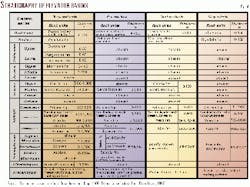
Strata that infill the Tucumcari basin are Mississippian through Early Permian in age (Fig. 4). Atokan (Early Pennsylvanian), Des Moinesian (Middle Pennsylvanian), and Canyon (Missourian; Upper Pennsylvanian) strata are thicker in the Cuervo sub-basin than on the adjacent shelf areas (Figs. 4, 5),13 indicating that the basin was actively formed during the Pennsylvanian. Atokan (Early Pennsylvanian) strata rest unconformably on Precambrian granites, metasediments, and metavolcanics as well as erosional remnants of Mississippian limestones and sandstones.
The Cisco (Virgilian: Upper Pennsyl- vanian) section is not present and was apparently removed by erosion during exposure in the latest Pennsylvanian. Subaerial exposure and karstification of Upper Pennsylvanian carbonates occurred during this time in the Palo Duro basin as well.23 Pennsylvanian strata in the Cuervo sub-basin consist of basinal shales and interbedded arkosic sandstones and conglomerates. These sediments were derived by erosion of the Precambrian core of the Sierra Grande uplift. The sub-basin acted as a sediment trap for coarse siliciclastic sediments transported into the basin by fluvial-deltaic systems. Pennsylvanian strata on the shelf to the south are dominantly shales interbedded with carbonates; sandstones are relatively minor on the shelf. Some of the carbonates have been dolomitized. Reynolds18 and Reynolds and Reynolds19 believe that the southern edge of the Cuervo sub-basin was the site of a fringing reef complex during the Pennsylvanian. Regional lithofacies maps suggest that most of this reefing occurred during the Desmoinesian and may have continued into the Missourian. Hueco (Wolfcamp- ian: Lower Permian) sandstones and shales and Abo (Wolfcampian: Lower Permian) conglomeratic sandstones and red shales constitute the upper fill of the basin.
Shales in the Strawn and Canyon sections are source rocks for gas and oil. Dark-gray to black shales have TOCs of 1-2%, sufficient for petroleum generation. Strata in the elevator basin are in the oil window. The Thermal Alteration Index (TAI), a standard measure of thermal maturity, exceeds 3.0 in the deeper parts of the basin, indicating that the source rocks have reached peak oil generation. Kerogens in the Pennsylvanian are dominantly gas-generative woody types and gas- and oil-generative herbaceous types. Burial history modeling indicates that peak oil generation occurred during the latest Cretaceous and earliest Tertiary.13
Although Hueco limestones and shales and Abo red shales are thermally mature in the Cuervo sub-basin, these strata contain less than 0.5% TOC, an amount insufficient for hydrocarbon generation. Strawn and Canyon strata are thermally mature on the shelf immediately south of the Cuervo sub-basin (Fig. 5), and many of the shales in that area contain more than 1% TOC.
These shelf deposits may also be good source rocks. However, shales on the shelf have not reached peak oil generation, and shales are thinner on the shelf than in the sub-basin. Because of the higher level of maturity and thicker section of source rocks in the sub-basin, a much larger volume of hydrocarbons was generated in the sub-basin than on the shelf. The sub-basin is the primary hydrocarbon kitchen.
Trementina sub-basin
The Trementina sub-basin is in southeast San Miguel County (Fig. 3). It trends west-northwest and cuts across the Sierra Grande uplift. It is bordered on the northwest by the central axis of the Sierra Grande uplift and on the northeast by the Pablo Montoya high, a southeast-projecting prong of the Sierra Grande uplift. On the south, the Newkirk anticline separates the Trementina sub-basin from the Cuervo sub-basin. On the southeast, it is connected to the Quay sub-basin.
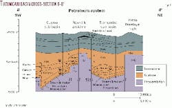
The Trementina sub-basin is 50 miles long and 10-15 miles wide. Depth to Precambrian basement is 8,000 ft along the central axis of the basin.13 Strata that infill the Trementina sub-basin are Mississippian through Early Permian in age (Figs. 4, 6). The Mississippian section consists of erosional remnants of limestones and sandstones that rest unconformably on Precambrian basement. Atokan (Lower Pennsylvanian) strata rest unconformably on the Mississ- ippian and are overlain by Strawn (Desmoinesian: Middle Pennsylvanian) and Canyon (Missourian: Upper Pennsylvanian) strata.
As is the case elsewhere in the Tucumcari basin, the Cisco (Virgilian: Upper Pennsylvanian) section is missing. Hueco (Wolfcampian: Lower Permian) carbonates and shales and Abo (Wolfcampian: Lower Permian) conglomeratic sandstones and red shales constitute the upper fill of this elevator basin.
Atokan, Strawn, and Canyon strata consist primarily of black shales and limestones. These intertongue with arkosic conglomeratic sandstones derived from the Precambrian rocks that were exposed on the uplifted margins of the basin during the Pennsylvanian.
Basin-fill black shales are thermally mature source rocks of oil and gas. In the Baker and Taylor 1 T4 Cattle Co. well in the southeast part of the Trementina sub-basin (Fig. 3), black shales in the Canyon have TOC values in excess of 9% over 200 ft of section, and black shales in the Strawn have TOC values in excess of 3% over 200 ft of section, substantially more than required for petroleum generation.
The Canyon shales are mature and in the oil window with TAI values of 2.7, and the Strawn shales are also mature with TM values of 2.7-2.8. Kerogens in the Canyon shales are dominantly herbaceous with secondary woody and amorphous types and inertinite. This combination of kerogens will generate oil and associated gas upon maturation. Strawn shales have approximately equal abundances of amorphous, herbaceous, and woody types of kerogens as well as inertinite and also are source rocks of oil and associated gas. In the north-central part of the Trementina sub-basin in the Miami Petroleum 3 Hoover Ranch well (Fig. 3), Strawn and Atokan shales are source rocks of oil and gas. They have TOCs of 1.3-2.8% and are in the oil window with TAI values of 2.6-2.7. They have dominantly herbaceous kerogens with secondary woody types and inertinites. Some of the shales contain substantial amorphous kerogens.
Trigg Ranch sub-basin
The Trigg Ranch sub-basin is located astride the boundary between San Miguel and Harding counties (Fig. 3). It trends northwest and cuts across the Sierra Grande uplift.
It is bordered on the northwest by the central axis of the Sierra Grande uplift, on the southwest by the Pablo Montoya high, and on the northeast by the Bravo dome. On the southeast, the Trigg Ranch sub-basin is connected to the Quay sub-basin. The Trigg Ranch sub-basin is 40 miles long and 5-15 miles wide. Although very sparsely drilled, maximum depth to Precambrian basement appears to be 6,000 ft.13
Limited data available indicate basin fill is mostly arkosic conglomerate and red shale deposited as alluvial fans shed off of the uplifts that border the basin.13 Source facies have not been identified. However, the central axis of the basin has not been drilled, and a euxinic source facies of black shale may be present.
Quay sub-basin
The Quay sub-basin is located in the northeast part of the Tucumcari basin (Fig. 3). It trends northeast and is bordered on the north and northeast by the Bravo dome. On the northwest, it is bordered by the Trigg Ranch sub-basin, the Pablo Montoya high, the Trementina sub-basin, and the Newkirk anticline. On the southeast, it adjoins the Frio uplift. To the southwest, it merges gradationally with the central shelf area of the Tucumcari basin. The Quay sub-basin is 45 miles long and 10 miles wide. Depth to Precambrian basement is more than 9,000 ft in the central part of the basin.13
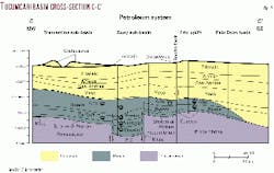
Strata that infill the Quay sub-basin are Mississippian through Early Permian in age (Figs. 4, 7). The Mississippian section consists of erosional remnants of limestones and sandstones that rest unconformably on Precambrian basement. Atokan strata rest unconformably on the Mississippian. The Strawn is overlain by Canyon strata (Missourian; Upper Pennsylvanian). The Cisco (Virgilian, Upper Pennsylvanian) section is missing. Hueco (Wolfcampian; Lower Permian) carbonates, shales, and sandstones and Abo (Wolfcampian; Lower Permian) conglomeratic sandstones and red shales constitute the upper fill of this elevator basin.
Strawn and Canyon strata consist of black shales and limestones that intertongue with conglomeratic arkosic sandstones derived mainly from the Precambrian cores of uplifts to the north and northwest and to a lesser extent from the Frio uplift. Strawn shales are thermally mature source rocks with Rock Eval Tmax values in the 440-475° C. range. TOC of the source facies is typically 1-2% but is as high as 6.5% in some shales, more than sufficient for petroleum generation.
The Rock-Eval Hydrogen Index is typically less than 150 mg hydrocarbon/ gram of organic matter, and the ratio of the S1 peak to the S2 peak typically ranges from 1-4 but exceeds 25 in some source rocks, indicating the presence of gas-prone and oil-prone kerogens (Peters24 has concise discussion of Rock-Eval parameters).
Tucumcari petroleum systems
A number of occurrences and shows of oil and gas have been encountered by wells drilled in the Tucumcari basin.13 25 26
Two major accumulations of heavy oil have been discovered in Triassic sandstones: the Santa Rosa tar sands located seven miles north of the town of Santa Rosa and Newkirk oil field on the Newkirk anticline (Fig. 3).25 27 28 Two pools of gas and light oil or condensate have been discovered in Strawn (Middle Pennsylvanian) sandstones in the Cuervo sub-basin: Latigo Ranch pool and TA Cattle Co. pool (Fig. 3).13 29
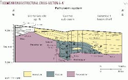
The Triassic heavy oils are in sandstone reservoirs interbedded with red shales. Newkirk pool contains 62 million bbl in place,25 27 and the Santa Rosa tar sands contain an estimated 90.9 million bbl in place.28 These oils are thought to have been generated in the Pennsylvanian section. Subsequent to generation, these oils migrated upward through deep-seated faults into the Triassic (Fig. 6).10 13 25 They were biodegraded after entrapment in the Triassic sandstones. Biodegradation turned light mobile oils into heavy immobile oils.
TA Cattle Co. and Latigo Ranch pools were discovered in the early 1980s in the Cuervo sub-basin. Strawn sandstones form the reservoirs for both pools. Hydrocarbons are gas with condensate or light oil. Absence of a gas pipeline resulted in these pools never being exploited or produced. Significant completion problems at Latigo Ranch field contributed to poor well performance and pool abandonment.29 T4 Cattle Co. pool remains shut-in.
A number of wells drilled in the Tucumcari basin have encountered shows of oil and gas.13 26
Shows in Strawn are found in coarse-grained arkosic sandstones in the elevator basins. Shows in Canyon occur in arkosic sandstones in the elevator basins and in carbonates and sandstones on the shelf south of the elevator basins. Shows in Hueco occur in coarse-grained arkosic sandstones in the elevator basins; the Hueco is also characterized by shows of live oil in porous carbonate bank dolostones on the Frio uplift. Shows in Abo occur in fine- to coarse-grained arkosic sandstones; most shows in the fine-grained sandstones are gas.
Significant shows of oil and gas have also been encountered in San Andres carbonates in the Tucumcari basin.
The concept of the petroleum system encompasses an interlinked system of source rocks, migration pathways, reservoirs, and traps.30 The source rocks in the Tucumcari basin are found mostly in the Atokan, Strawn, and Canyon sections in the elevator basins and to a lesser extent in thinner coeval strata on the shelf just south of the elevator basins (Figs. 5, 6, 7).
Shallower strata are either thermally immature or contain insufficient organic matter for hydrocarbon generation. Oil and gas shows and the presence of T4 Cattle Co. and Latigo Ranch pools indicate that a portion of the generated hydrocarbons was trapped in sandstones in the elevator basins. Other hydrocarbons, however, migrated upward along faults that bound the elevator basins.
From the faults, the hydrocarbons migrated into shallower strata. This migration led to the formation of Newkirk pool (Figs. 3, 6) and also resulted in migration of hydrocarbons into Pennsylvanian and Lower Permian shelf strata south of the elevator basins where shows of live oil and gas have been encountered.13
Some of the reservoirs may be in a Pennsylvanian barrier bank complex just south of the Cuervo sub-basin.18 19 This barrier bank complex has been partially dolomitized.13
Next: Petroleum systems described in Estancia, Carrizozo, and Vaughn basins
