Black Warrior Knox gas production on growth trend in Mississippi
The Black Warrior basin in Mississippi has the potential for significant gas reserves in Cambro-Ordovician rocks. Evidence for this potential has been accumulating through the years as occasional wells tested the sequence.
Before considering this potential here, we briefly develop a case using the larger context of the authors' national experience in these rocks.
Ordovician plays
The Ellenburger-Arbuckle plays of West Texas and Oklahoma are clear examples of major reserves associated with fields in these strata. A brief survey of these reservoirs reveals porosity origins from matrix porosity, fractures, karst-developed caverns, and collapse breccia.
Production from the Cambro-Ordovician occurs in the eastern US, also. Many smaller oil and gas fields occur in south-central Kentucky and north-central Tennessee. Like the western counterparts, the reservoirs are commonly formed as a result of karstification and paleogeomorphic highs as well as fracture and matrix porosity.
In Swan Creek oil and gas field, Hancock County, Tenn., the high-energy sediments of a shoreline-nearshore shallow water depositional environment resulted in primary porosity values of 6-18%. Fracture porosity also contributes to the reservoir. The field is portrayed as a subthrust structure beneath the Clinchport thrust.1
The Ohio Geological Survey informed us of a multiyear Cambro-Ordovician play in which operators mainly target paleogeomorphic highs. However, a recent gas discovery had a 3-ft free fall of the bit in a karst cavern.
In southern Michigan, the Ordovician Trenton and Black River formations show extensive karst-cavern development in the Albion-Scipio Trend.
TotalFinaElf's interests
From west to east and then north, these Cambro-Ordovician units are present and producing in several areas of the continental US.
Most of the above-cited production has occurred at relatively shallow depths where low cost has allowed many small operators to drill for these targets. The case can be made from all of this experience that the deeper-lying Cambro-Ordovician should prove to be a reasonable exploration target.
Undoubtedly many companies have looked at the Cambro-Ordovician potential east and west of the Mississippi River, but few have accepted the challenge of deep exploration in both areas. One company that has is TotalFinaElf unit Fina Oil & Chemical Co.
Several years ago Fina's management became convinced that there had to be significant potential in these deeper Cambro-Ordovician rocks. One demonstration of Fina's commitment to this bold exploration effort was the permitting of a 26,000-ft wildcat to Ellenberger southwest of San Antonio in Medina County, Tex. This well was so interesting that it was the subject of an article in the AAPG Explorer in November 1994. The well reached a TD of 23,000 ft and was abandoned in May 1995.
Fina has shown continued interest in the development of possibly significant gas reserves in deep Cambro-Ordovician rocks by its exploration-development work in Mississippi. The company's efforts are meeting with good success there.
At Maben field in Oktibbeha County, Miss., Fina is involved in an intensive and ongoing development drilling program, expanding the field's areal extent and increasing gas production dramatically from the "Knox-Ordovician" (also called Stones River dolostone or "Snow Zone").
Mississippi drilling
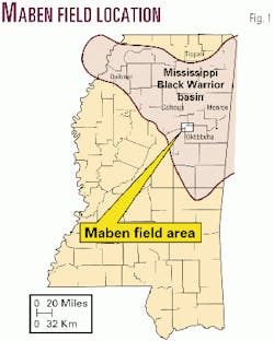
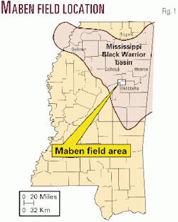
The history of drilling the Cambro-Ordovician in northern Mississippi's Black Warrior basin has resulted in some encouraging well data (Fig. 1). Here are highlights from Henderson, 1991.2
In 1979, Tipperary Oil & Gas drilled its 1-X Harpole-Campbell Energy well in Quitman County, Miss., to a depth of 10,694 ft. While drilling, a 24-ft "fall of the bit" was encountered when a karst cavern and collapse breccia sequence was penetrated.
Henderson placed this karst development in the Copper Ridge dolostone of the Knox Group. On a drillstem test of the interval 7,585-7,632 ft, the well flowed 18,000-ppm salt water at a rate of 12,300 b/d of water in the first 5 min.
In Calhoun County, the Honolulu 2 Davis well, completed in 1954, encountered a karstification zone at 8,134-8,390 ft in the Knox dolostone. A DST over this interval recovered 3,000 ft of gas and mud-cut salt water.
In Monroe County, the Magnolia Petroleum 1 Pierce well was drilled into a karst interval in the Knox limestone. A DST at 7,160-76 ft yielded 6,210 ft of gas-cut black sulfur water (720 bbl of water). The well was plugged in 1954.
In Tippah County, the Memphis Equipment 1 Melton well drilled in 1956 encountered a "reef type" crinoid zone at 2,980 ft that was DSTd and recovered 2,400 ft of salt water in 30 min. This zone is also in the Knox limestone.
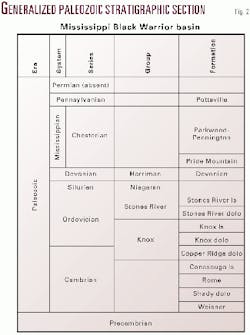
In 1953, the Magnolia Petroleum A-1 Snow well found oil at a depth of 4,753 ft at New Hope field in Monroe County. Although the well produced a total of 7,832 bbl of 35° gravity oil, its initial rate was reported at 29 bbl/hr. The zone of production was named the "Snow Zone," and Henderson puts this zone in the Ordovician Stones River Group (Fig. 2).
The "Snow Zone" was found gas productive in 1971 in the Texaco Inc. 1 Sheely, discovery well for Maben field in Oktibbeha County (Fig. 1). The well was completed from perforations at 14,690-15,036 ft and reported to have flowed at a rate of 1.959 MMcfd. What characterized this production was low volume over a protracted period of time with no decline. The field's history and production are discussed below.
Maben field discovery
Maben and South Maben fields are two of only three fields that are producing or have produced oil or gas from the "Knox-Ordovician" in Mississippi.
The fields are in northeastern Mississippi on the southwestern flank of the Black Warrior basin, 10 miles west of the city of Starkville, in townships 18n-12e and 19n-12e, Oktibbeha County, Miss. (Fig. 1).
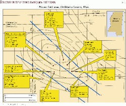
Maben field was discovered in July 1971 with completion of the Texaco 1 Sheely in 28-19n-12e (Fig. 3). The 1 Sheely was drilled to TD 17,442 ft.
Texaco tested several zones in the shallower Mississippian, one of which was deemed noncommercial, and a deeper interval in the Lower Knox. The 1.979 MMcfd rate was tested through perforations at 14,690-784 ft and 14,904-15,036 ft in the "Knox-Ordovician" as reported by the Mississippi State Oil & Gas Board but more correctly in the Stones River dolostone.2
The well was completed flowing 599 Mcfd on a 9/64-in. choke with 1,000 psi flowing tubing pressure.
For many years, monthly gas production from the 1 Sheely has ranged generally from 3,000-5,000 Mcf/month. In November 2000, the 1 Sheely produced 3,037 Mcf of gas in 30 days. Present operator is Energy Properties Inc., Metairie, La. Cumulative production from the well through Dec. 31, 1999, was 1,241,398 Mcf of gas and 78 bbl of water.
Humble Oil & Refining Co. (now ExxonMobil) spudded the first attempt to offset the discovery in July 1972. The 1 M.S. Fulgham well, in 33-19n-12e (Fig. 3), 4,000 ft south of the 1 Sheely, was drilled to TD 21,376 ft and bottomed in Cambrian Knox. After unsuccessfully testing perforations at 14,816-15,177 ft, 19,200-20,043 ft, and 20,601-21,265 ft, Humble plugged and abandoned the well in March 1973.
Redevelopment, production
No further development drilling occurred in the Maben field area for almost 25 years until Fina spudded its 1 Sanders well in September 1997.
Fina drilled the 1 Sanders, 8,000 ft east of the discovery well (Fig. 3), to TD 15,000 ft in the Knox. It completed the well in June 1998 flowing 1,537 Mcfd of gas and 1 b/d of water from perforations at 14,224-14,667 ft in the "Knox-Ordovician" with FTP of 150 psi on a 48/64-in. choke, after a 40,000 gal acid treatment.
During the first full year of production the 1 Sanders averaged over 5,650 Mcfd (Fig. 4). As of Dec. 31, 2000, cumulative gas production was 4,762,847 Mcf of gas. The 1 Sanders well is believed to be fault separated upthrown to the Sheely and Fulgham wells and is 600 ft structurally high to the 1 Sheely. Because of the much higher production rates, porosity and permeability are believed to be enhanced by fault-induced fracturing.
Since the completion of the 1 Sanders, Fina has drilled three more wells in the Maben field area. Two have resulted in successful development wells completed in the "Knox-Ordovician" gas reservoir at Maben field.
Fina completed the 2 Richardson in December 1999 flowing 865 Mcfd and 2 b/d of water on a 48/64-in. choke with 175 psi FTP from open-hole interval at 14,000-901 ft. The well had been drilled to a TD of 15,700 ft. The well, in 35-19n-12e, is a 1-mile south-southeast offset to the 1 Sanders well and is believed to be completed in the same upthrown fault block (Fig. 3).
In September 2000, Fina completed its 1 Love Heirs well in 22-19n-12e as a one-half mile northwest offset to the 1 Sanders well. It is structurally 93 ft high to the 1 Sanders at the top of the Stones River and is also believed to be completed in the same upthrown fault block (Fig. 3).
The 1 Love Heirs was tested in two separate sets of perforations in the "Knox-Ordovician" gas reservoir. Perforations at 14,387-594 ft flowed 5,700 Mcfd, and later perforations at 14,180-316 ft tested 2,656 Mcfd. In the first full month of production the well produced 314,151 Mcf of gas.
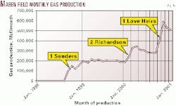
As a result of Fina's drilling successes at Maben field, monthly gas production has increased dramatically. With the production of three new wells being added over the 26 months ended in October 2000, production has stepped up from slightly over 3,000 Mcf/month to more than 580,000 Mcf/month (Fig. 5). As of Dec. 31, 2000, cumulative production for the "Knox-Ordovician" at Maben field was nearly 8.4 bcf of gas.
The third well was completed as a gas well in the "Knox Gas" pool and has been designated a new field discovery. Fina drilled the 1 Georgia Pacific, in 5-18n-12e, 11/2 miles southwest of the 1 Sheely, to a TD of 16,100 ft. Completed in June 1999, the 1 Georgia Pacific well flowed 436 Mcfd with no water on a 6/64-in. choke and FTP of 3,580 psi from perforations at 15,338-830 ft. The well is structurally 475 ft low and believed to be fault-separated downthrown from the Maben field discovery well (Fig. 3).
The 1 Georgia Pacific has been designated as the discovery well for South Maben field. This well's gas production is characterized as being similar to that of the 1 Sheely with low monthly volumes ranging from 3,000-5,000 Mcf/month. At this writing no additional drilling has been permitted offsetting this well.
Current, future activity
In late March 2001, Fina was drilling below 16,093 ft in a sidetrack hole at the 1 Winters, a development well 36-19n-12e, 3 miles south-southeast of the 1 Sheely well. Planned TD for the Knox Ordovician test well is 16,640 ft.
Additionally, Fina has permitted two new development locations and a re-entry-horizontal sidetrack of the original Exxon 1 Fulgham well. The two new drilling locations will be attempts to extend the good gas production seen at the 1 Love Heirs well to the northwest into sections 21 and 17-19n-12e (Fig. 3). Both wells are permitted to 15,700 ft. Wells are spaced on 640-acre units.
Energy Properties staked a Knox test, 1 Hamilton, to 15,700 ft in the same square mile with the 1 Sheely. The company received state approval to produce the new well, if successful, simultaneously with the 1 Sheely.
Rocks and structure
The Stones River dolostone (Fig. 2), as described by Henderson,2 is mostly light gray to light grayish-tan, very fine to finely crystalline dolomite with some beds of fine to medium crystalline dolostone in the upper section.
Varying amounts of argillaceous materials are found within the Stones River dolostone, but generally the amount increases in the middle of the unit. Locally thin beds of green shale are present in the lower half. Sand is generally absent though locally small amounts of very fine to fine grained quartz sand may be present with the amount of sand increasing towards the base of the section.
Minor amounts of chert are locally present with most of the chert being secondary, filling voids and occurring as replacement of the original carbonates. The Stones River dolostone in the 1 Sheely well is 420 ft thick, the top picked at 14,670 ft and the base at 15,090 ft. No porosity or permeability information was available to the authors.
Based on a limited amount of subsurface data, reported or published well data, and discussions with individuals familiar with the area, a generalized and conservative structure map on the "Top of the Stones River (Knox-Ordovician)" was constructed and is included here (Fig. 3).
Structurally the Maben field area appears to be a faulted anticlinal feature with several normal down-to-the-southwest faults which strike from northwest to southeast across the feature. Fault displacements appear to range from 150 ft to nearly 600 ft. Northern dip components shown have not been verified by drilling results.
Vast gas trend
If the bright future for domestic exploration companies is in natural gas then the Cambro-Ordovician looks like a play to consider.
From recent successes in New York to West Virginia and Mississippi, it becomes apparent that these rocks can deliver. Our featured field shows the deliverability and sustained production levels that make for worthy exploration targets.
The challenge will be determining how to explore for similar fields. It appears that Fina is off to a good start and that Columbia Gas has a hot hand in the Appalachian basin.
Mississippi, like most of the eastern US, has a large Cambro-Ordovician section that is very lightly explored. That light exploration has shown structures, porosity, and a new significant discovery-not a bad combination.
Acknowledgments
The authors acknowledge the assistance of Ron Riley with the Ohio Division of Geological Survey, Dave Harris of the Kentucky Geological Survey, Jock Campbell with the Oklahoma Geological Survey, Bob Loucks of the Texas Bureau of Economic Geology, John Harper of the Pennsylvania Geological Survey, and the West Virginia Geological Survey. All of the above gave us brief status reports on the Cambro-Ordovician plays in their respective states.
References
- Clendening, J., "Swan Creek field: Potential giant develops in East Tennessee," OGJ, Apr. 19, 1999, p. 95.
- Henderson, Kevin S., "Cambro-Ordovician subsurface stratigraphy of the Black Warrior basin," Report of Investigations 2, Mississippi Department of Environmental Quality, Office of Geology, 1991.
Bibliography
Mississippi Department of Environmental Quality Office of Geology, Energy Library Web site, http://library.geology.deq.state.ms.us, 2001.
Mississippi Oil & Gas Production Annual Report 1999, Mississippi State Oil and Gas Board, 2000.
Mississippi State Oil & Gas Board website, well data production reports, http://www.ogb.state.ms.us, 2001.
Southeastern Oil Review, Oct. 19, 1998.
Southeastern Oil Review, Sept. 25, 2000.
Southeastern Oil Review, Apr. 30, 2001.
The authors
Stephen D. Champlin is a geologist in the Energy Section of the Mississippi Office of Geology. He was involved in oil and gas exploration and development in Gulf of Mexico federal waters and onshore southeastern US for 17 years before joining the Office of Geology in 1993. He has held positions with Gulf Oil Corp., Getty Oil Co., and Dixie Energy Corp., and was a consultant in Jackson, Miss., for 10 years. He has a BS degree in geology from the University of Alabama. E-mail: [email protected]
Jack Moody is director of the Energy & Coastal Division of the Mississippi Office of Geology. Before joining the office in November 1998 he spent 17 years in industry as an exploration manager and-or geologist. He received a BS degree in geology from East Carolina University and then spent 2 years in graduate studies in geology at Louisiana State University. E-mail: [email protected]
Correction
The callouts "Burgos basin (1987-2015). First production year = 14 (2000)" and "2000 Burgos production" in the figure here were not readable in an article earlier this month (OGJ, May 7, 2001, p. 72). The corrected figure is published at left.
