Canada's unexplored lands: Deer Lake basin case study
The Deer Lake basin onshore western Newfoundland is a classic case of an unexplored hydrocarbon bearing basin in the settled part of North America.
Bounded on two sides by bold granitic highlands marking the basin's east and west bounding faults and one part rolling farms and nine parts lakes, bog, and pulpwood forest, the basin is known for its hunting and salmon fishing but not its oil and gas potential.
But with a fully developed infrastructure including jet airport, major transmission lines, and all-weather Trans Canada Highway and a deepwater year round seaport and university center only 10 miles to the south, the area can hardly be called remote or a "frontier."
And yet, while the basin's oil and gas potential has been known for at least 80 years, the industry has practically ignored the area.
This article suggests that this may be a case of "hiding in plain sight" and describes how Deer Lake Oil & Gas Inc. went about drilling a gas discovery with the first modern well there.
After an 8 year search, we can say with confidence that the Deer Lake basin has all the necessary characteristics to become a significant oil and gas producing area. While it remains to be seen whether our Western Adventure gas discovery is commercial, it is clear that there are still some "new basins" to be explored in the settled part of North America and that the "frontier" is sometimes all in our own minds.
Basin overview
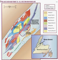
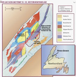
Deer Lake is an intermontane, strike-slip, pull apart, rift type land basin, one of four rift basins that make up the West Newfoundland rift basin system (Figs. 1, 2).
It contains a thick sequence of Carboniferous aged alluvial, fluvial, and lacustrine units overlying locally Ordovician aged carbonates and Cambrian aged clastics.
Devonian and Silurian aged rocks may also be present locally at depth.
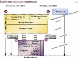
The Carboniferous package is divided into two megasequences, the Anguille Group (Tournasian) and the Deer Lake Group (Visean), which are separated by a major unconformity (Fig. 3).
The megasequences are each divided into three distinct phases with a lacustrine middle phase sandwiched between alluvial/fluvial packages. Several periods of basin subsidence have taken place.
The basin is divided by a central flower structure into two distinct half-graben sub-basins: the Cormack sub-basin on the west and the Howley sub-basin on the east where the Westphalian aged Howley formation is also present.
The depth to basement (i.e., the Grenville) is unknown, but geophysical evidence supports a minimum of 4+ km. An extra 1.5 to 2.0 km of post Carboniferous sediments are thought to have been removed by erosion.
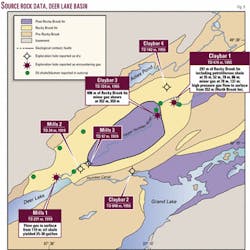
In 1955-56, Claybar Oil & Minerals conducted the first oil and gas drilling program in the basin, drilling four relatively shallow wells without benefit of seismic.
Two were dry, one had a gas show, and Claybar 1 blew out while drilling through a fine grained sandstone unit of the North Brook formation and flowed gas and salt water under "high pressure." The zone was cemented and not tested.
The first 13 km of commercial quality seismic was shot in 1994. Another 37 km was added in 1997-98.
Getting started
When Deer Lake set to work in 1993, the basin was generally considered of little interest to explorers as it was thought to be too small, too shallow, and gas prone.
But a remarkable diversity of materials questioned those assumptions. These ranged from the personal correspondence of one T. Landell-Mills as he reflected on his ill-fated 1919 oil shale drilling operations which were abruptly terminated by a natural gas blowout, to a seminal paper on the West Newfoundland rift basin system by Belt in 1967,1 to detailed Rock-Eval studies of potential source rocks.2
Our own work helped give rise to two important papers, one in 1994 on the first seismic survey3 and a major petroleum oriented review in 1997.4
But perhaps most persuasive was a well curated collection of some 24,000 ft of mining core covering both source and reservoir rock sequences. This collection has been particularly useful for porosity and permeability studies.
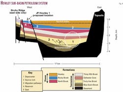
The framework for our search was the petroleum system concept,5 which we applied to a first order visualization of our proposed J.P. Howley well in the Howley sub-basin (Fig. 4). No seismic or oil and gas drilling had taken place.
Like most powerful ideas, the petroleum system concept is rather simple: An organically rich source rock is "cooked" in the depocenter or "kitchen" to the right temperature to mobilize hydrocarbon material and is connected by migration pathways to a trap which is sealed so as to constrain further hydrocarbon fluid movement beyond a porous reservoir that has sufficient storage capacity and permeability to allow the hydrocarbons to be produced in commercial quantities when penetrated by the drill.
All of this must happen in accordance to an effective sequence of events. For instance, trap formation must precede the peak generating and migration period. In the Deer Lake basin, the important period of trap formation was in the late Carboniferous, while peak generation seems to have been later, in the Permian.
Generation, fill adequacy
Many basins have great reservoirs and traps but have generated inadequate hydrocarbons to even partially fill them. In a new basin, this often represents the greatest exploration risk.
In our case, over 6,000 ft of mining core from the Rocky Brook formation, one of our two main source rocks, was the basis of a series of excellent publications on organic richness, volume, and maturation levels.2 4
In addition, degraded oil occurs in outcrop on the west side of the basin and in mining core to the east of the central flower structure. In both cases, samples still contain enough light ends to allow a "finger-printing" process to tie the oil to a particular lacustrine algae indicating one of two candidate formations.
Both the Rocky Brook formation and the older Forty-five Brook formation have a similar Type 1 oil prone lacustrine character, and either could be the source (Fig. 5).
The Rocky Brook formation, including oil shale grade units, is present throughout both sub-basins and is marginally mature at the surface. Seismic indicates that the formation is thicker and deeper in the central part of the western sub-basin and in that area should be in the oil window.
Outcrop of the older Forty-five Brook formation from the west side of Grand Lake is in the middle of the oil window where uplifted and exposed in the central flower structure.
Less is known about the Forty Five Brook formation, but the Rocky Brook is clearly capable of generating substantial amounts of hydrocarbons. Rocky Brook has a gross thickness of 300-1,000 m and individual beds ranging up to 15% total organic carbon (TOC).
Another measurement
The vast majority of the oil or gas generated in any basin will "dead end" along a migration pathway or escape into the air or sea, so the next step in any new basin is to try and get a feel for the local generated to accumulated efficiency (GAE).
A high GAE requires good migratory paths and efficient traps close to the source. This is why "small" basins often have higher GAEs than larger basins.
For example, the 1,200 sq km Big Snowy Trough basin of central Montana has an amazing GAE of 36%, which is explained because of effective carrier beds and the short distance from source to trap.
Large basins can make up in volume of source rock what they lack in efficiency. On Alaska's North Slope the source is 350 miles to the south and the calculated GAE 0.9%, but Prudhoe Bay is still a supergiant find.
In the Deer Lake basin, the distance from source to the traps associated with the central flower structure is 10-15 miles.
Excellent dissolution porosity in potential carrier beds and a well developed fault system are thought to provide good migration pathways over these short distances.
Trapping mechanism
At the end of any good migration pathway must be a good trapping mechanism.
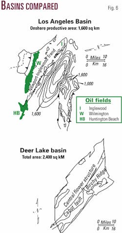
The Los Angeles Basin is a good example of putting it all together. Its reserves are 9 billion bbl of oil and 7.5 tcf of gas, all from an area smaller than the Deer Lake basin (Fig. 6).
Size aside, the Deer Lake basin is strongly analogous to the Los Angeles Basin with regard to tectonic and trapping style; both are strike-slip, pull apart basins, both are edge of plate movement induced, and both share a distinctive central flower structure.
The Los Angeles Basin central flower structure is manifest as the Newport-Inglewood Trend, home to much of that basin's oil production. These fields are noted for their relatively small areas, large vertical closures, and multiple stacked reservoirs.
The Deer Lake basin central flower structure is represented by the Birchy Ridge-Glide Mountain Trend. The Western Adventure and J.P. Howley structures are outboard structural elements of this trend.
We assume a 20% GAE for the Deer Lake basin and conclude that combined the basin's generative capacity and its GAE are more than adequate to fill traps of giant size (i.e., greater than 100 million bbl recoverable) if present.
Potential reservoirs
The porosity in all reservoir quality rocks found so far in the Deer Lake basin results from a pervasive dissolution event that was the final stage in the diagenetic sequence apparently dominant throughout the basin.6 This dissolution event attacked previous stage calcite cementation and sometimes dissolved the matrix grains themselves.
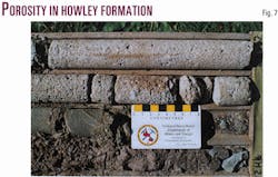
Under this influence, the North Brook and Howley formations have measured porosities up to 40% and permeabilities in the hundreds of millidarcies and Darcy range. Where the event is strong, reservoir quality sequences typically occur in a stacked manner with individual porous units from 1 m to 5 m thick.
Determining the factors that control the presence and intensity of the dissolution event is one of our most pressing exploration tasks.
Core from a sandstone unit of the Howley formation in the Howley sub-basin contains excellent dissolution porosity (Fig. 7).
Western Adventure 1
Deer Lake Oil & Gas operates Exploration Permit 93-103, some 29,000 ha astride the northern part of the central flower structure.
The first drilling objective was the Western Adventure Prospect, a 20-30 sq km anticlinal target on the west flank of this feature. In 2000-01 we continuously cored the Western Adventure 1 well to 1,879 m to test one of four fault blocks that make up this structure.
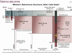
Western Adventure 1 encountered a complete section of the North Brook formation measuring 1,035 m consisting of three sequences each of similar thickness:
- A basal alluvial fan/meandering stream phase.
- A middle braided stream sequence.
- A final meandering stream phase fining up into the lacustrine shale dominated units of the Rocky Brook (a regional top seal).
These results confirmed our pre-drilling model.
When compared to the North Brook section in Claybar 1, 11 km north, Western Adventure 1 confirmed a major north to south thickening of the North Brook overlain by a constant thickness of Rocky Brook formation demonstrating major basin subsidence and infilling in North Brook time (Fig. 8).
The dissolution event is present but relatively poorly developed at this location, and the resulting porosity and permeability are relatively low due to calcite cementation.
Fortunately, the relatively low matrix permeability is partly offset by fracture porosity and permeability of a tectonic nature.
The well had a condensate show at 850 m and flowed gas on drillstem test at a rate of 100 Mcfd at 1,600 m. The well is suspended at 1,879 m.
Future drilling
Deer Lake is seeking farm-out partners to fund a two-well program:
- A 1,000 m delineation well on the Western Adventure gas discovery to evaluate the North Brook upstructure and test for the presence of fractured and karsted sections of the Ordovician carbonate platform at depth.
- A 600 m test on the J.P. Howley Prospect to evaluate the top 450 m of the North Brook formation.
Both these wells will be preceded by a seismic program and cased so that they can be deepened with encouragement.
Slimhole drilling
We used a modified Longyear Super 50 slimhole mining rig to continuously core and evaluate Western Adventure 1 to 1,879 m, perhaps our chief departure from normal oilfield tactics.
It is our experience that, properly modified, the converted mining rig can perform like a rotary (i.e., drill, set, and cement casing, maintain proper well control via a closed circulation mud system, monitor mud gas levels, manage lost circulation zones, take kicks, run Schlumberger type logs, and drillstem test). Fishing demands special care but can be carried out.
Given the high mobilization, demob, and other service costs associated with the use of conventional rotaries in western Newfoundland, we would use slimhole mining rigs for any target less than 1,500 m deep.
References
- Belt, E.S., "Newfoundland Carboniferous Stratigraphy and its Relation to the Maritimes and Ireland," in Kay, M., ed., "North Atlantic-Geology and Continental Drift," AAPG Memoir 12, 1967, pp. 734-541.
- Kalkreuth, W., and MaCauley, G., "Organic petrology and Rock-Eval studies on oil shales from the Lower Carboniferous Rocky Brook Formation, Western Newfoundland," Bull. of Canadian Petroleum Geology, Vol. 37, 1989, pp. 31-42.
- Wright, J.A., et al., "The Deer Lake Basin, Newfoundland: Structural constraints from new seismic data," Bull. of Canadian Petroleum Geology, Vol. 44, 1996, pp. 674-682.
- Hamblin, A.P., et al., "Stratigraphy, palynology and source rock potential of lacustrine deposits of the Lower Carboniferous (Visean) Rocky Brook Formation, Deer Lake Subbasin, Newfoundland," Bull. of Canadian Petroleum Geology, Vol. 45, 1997, pp. 25-53.
- Magoon, L.B., and Dow, W.G., "The petroleum system from source to trap," AAPG Memoir 60, 1994.
- Gall, Q., and Hiscott, R.N., "Diagenesis of Locally Uraniferous Sandstones of the Deer Lake Group and Sandstones of the Howley Formation, Carboniferous Deer Lake Subbasin, Western Newfoundland," Bull. of Canadian Petroleum Geology, Vol. 34, 1986, pp. 17-29.
Adapted from a paper given at the Canadian Institute of Mining, Newfoundland Chapter, St. John's, Newf., Nov. 2, 2001.
The author
Cabot Martin is president and CEO of Deer Lake Oil & Gas Inc., which he founded in 1998. He was a founder of Vinland Petroleum Inc. in 1991. He was a senior policy adviser to the Newfoundland & Labrador Premier in 1979-85, legal adviser to the minister of mines & energy for offshore oil and gas in 1971-72, and oil industry corporate counsel in Calgary in 1970-71. He holds degrees from Memorial University of Newfoundland and Queens University. [email protected]
