Exploration Geology, potential of Pande gas field, Mozambique basin
Pande gas field is extensive, measuring 20 km by 25 km, and is an undeveloped, high calorific, dry gas accumulation.
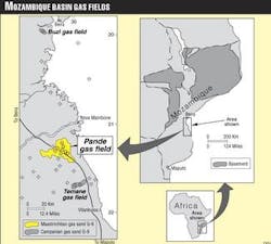
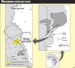
It is located onshore about 600 km northeast of Maputo and about 20 km from the coast in Inhambane Province of southern Mozambique (Fig. 1). The Maputo to Beira national road cuts through the field.
Gulf Oil discovered Pande field in 1961 with the Pande 1 well, which was drilled to 3,587 m and is the deepest on the structure. Gulf drilled the Pande 1 to 5 and North Pande 1 between 1961-66 to explore the productive structures of the Lower Grudja formation. These wells are 4-6 km apart; all show the existence of substantial volumes of gas.
In October 1965 a blowout occurred at the Pande 4 well during preparation for a formation pressure test. The G-6, G-10, and G-11 gas horizons were open to the borehole.
The blowout lasted 459 days until a directional relief well, Pande 4D, was drilled. It was stopped by injecting heavy mud into the G-11 horizon. After that, the formation pressure in the G-6 accumulation dropped to 102 atm from 119 atm and remains at the lower value today. It is obvious that the main energy of the gas blowout was associated with the G-10 and G-11 horizons.
The Pande 5 and North Pande 1, drilled after the blowout, confirmed that the G-6 gas accumulation remained undestroyed. Pande 1 was production tested in September 1971 to assess the effect of the Pande 4 blowout.
ENH started active exploration of the field in 1989. During 1989-90 six exploration wells were drilled in Pande field, Pande 6, 7, 8, 9, 10, and 11. They were operated by Tyumengeologia Association of Russia and ENH. All the wells yielded commercial gas production from the G-6 horizon. The Pande 11 well is particularly encouraging, demonstrating a wider than expected G-6 pay extent and excellent gas productivity potential.
A 725 line km, 30 fold seismic survey was conducted in the Pande area in 1990 and 1993. ENH experts in May 1994 completed the interpretation of new seismic data. Gas reserves have now been estimated at 113.0 billion cu m (3.99 tcf), including the proved gas reserves of 76.5 billion cu m (2.7 tcf).
In June 1994, Norwegian Petroleum Directorate fulfilled an independent assessment of Pande gas reserves. It estimated the expected gas reserves at about 115 billion cu m.
Lithostrat features
The geologic section of Pande field appears as a sequence of Cretaceous through Cenozoic age.
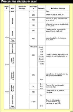
The Pande 1, TD 3,562.5 m in Lower Cretaceous Sena formation sediments, exposed the field’s most complete geologic section (Fig. 2). Based on seismic data, the overall thickness of the sedimentary column above the Karroo basalts surface in the field area exceeds 5-5.5 km.
Cretaceous, Paleogene, and Neogene sediments are widespread over the whole of the Mozambique basin. A number of continental, transitional, and marine facies have been identified. The general continental/marine facies change takes place in the eastern direction coinciding in space with the present-day shoreline. According to drilling data, several formations can be identified in the Pande area that are also developed in other areas of the Mozambique basin:
- Sena formation (Lower Cretaceous) occurs as multicolored alluvial-proluvial arkose sandstones, conglomerates, argillites containing freshwater and brackishwater fauna and vegetable detritus. The upper part of Sena deposits was penetrated in Pande field with the thickness of 700 m represented by an alternation of thin-fragmented rocks: argillites, shales, different-grained sandstones, and some limestone units. Based on logging data, a number of sand reservoir horizons have been identified within the Sena formation (S-1, S-2, etc.) that are favorable for hydrocarbon accumulation. Sena formation total thickness is less than 2,000-2,500 m in the field.
- Lower Domo shale formation (Cenomanian) discordantly overlies the Sena sediments occurring as dark argillites with lenses of arkosic sandstones. A thin succession of shaly rocks with the presence of marine fauna is a clear indication of their marine genesis. The formation thickness within Pande field is 120 m.
- Domo sand formation (Cenomanian-Turonian) is represented by quartzous sandstones with some interbeds of dark argillites unconformably overlying the Lower Domo shale sediments. The formation is 95 m thick in the Pande-Temane area. A number of sandstone horizons (D-1, D-2, D-3) with shale interbeds can be identified on Pande 1 logs.
- Upper Domo shale formation (Turonian-Lower Senonian) is composed of a sequence of dense, dark-gray argillites with occasional sandstone interbeds. The formation deposits discordantly overlie the underlying sediments. This formation was 675 m thick in the Pande 1.
- Lower Grudja formation (Upper Senonian-Lower Maastrichtian) is lithologically represented by glauconite-quartzous sandstones, shales, and shaly marls that were formed in a shallow shelf environment. This is the primary gas-bearing formation in the Mozambique basin. Over eight sandstone horizons can be identified within the Lower Grudja sequence of Pande gas field, which were labeled from top to bottom as G-6, G-7, G-8, G-9, G-10, G-11, G-11a, and G-12. Lower Grudja is 830 m thick in Pande 1.
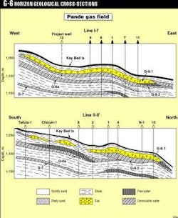
At the top of the formation there is a thin (3-6 m) limestone or marl horizon that is confidently recognizable on log curves and is therefore a good correlation marker called “Key Bed” limestone.
- Upper Grudja formation (Upper Maastrichtian-Lower Eocene) appears as an alternation of glauconite-quartzous sandstones with the beds of shales, marls, and limestones. These are shallow-water marine sediments commonly spread within the Mozambique basin discordantly overlying the lower sequences. Sandstone horizons are discontinuous in thickness and are bedded as big lenses. The thickness of Upper Grudja is 490 m.
- Cheringoma formation (Middle to Upper Eocene). The deposits of this formation occur as a carbonate sequence: nummulitic limestones and sandstones, dolomites, argillaceous limestones that were deposited in a carbonate shelf environment. The formation sediments are continuous in composition and thickness over the whole Pande field and adjacent areas. Thickness is 140 m.
- Miocene sediments comprise the following formations: Inharrime, Temane, and Jofane. Total thickness is 510 m. The Inharrime and Temane formations occur as evaporite sediments, and Jofane formation as shallow water shelf carbonates.
Reservoirs and traps
Gas accumulations have been discovered in G-6, G-10, and G-11 sand horizons.
G-6 sand (Lower Maastrichtian) is the main pay horizon containing the bulk of the proven gas reserves. Commercial gas flows have been obtained in all the wells located inside the amplitude anomaly area (“bright spot”). The wells located outside the anomaly spot on G-6 horizon level (Pande 3, Mudjige 1, Chicuir 1, and others) are dry holes.
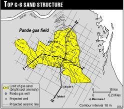
For the Pande area, seismic amplitude anomaly was adopted as a gas presence indicator, and the distribution area of such anomaly was regarded as the gasiferous area. Total area of amplitude gas anomaly is about 580 sq km (Fig. 3).
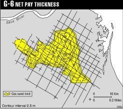
Lithologically, the G-6 horizon is composed of two beds separated by an unconformity. The upper bed (G-6.1) occurs as quartzous, semi-arkosic sand with glauconite, friable, medium to coarse-grained. Porosity values range from 29-33%, water saturation from 27-33%. Gas permeability varies between 185 md to over 1,900 md. In the Pande 11 well, gas permeability determined by core samples was in excess of 4,000 md. The thickness of G-6.1 sand ranges in different wells between 6-15 m, being an average value equal to 8.9 m (Fig. 4). This is the sand stratum to which the main commercial gas accumulation of Pande field is associated.
The lower bed (G-6.2) occurs as argillaceous fine-grained sand with a clay content increasing with depth. Porosity in the lower portion of the horizon is 27-28%, and water saturation rises to 50-80%. Gas permeability is never greater than 60 md.
The sand body was formed during a lowstand basin stage when individual bars were leveled at the expenses of washing-out micro-delta progradation sediments on a shallow-water shelf.
The whole gas sand is overlain by a sequence of shales with a thickness of 30-40 m. The above sediments were formed during the upperstand of the basin.
It is assumed that the G-6 gas accumulation is associated with a combined stratigraphic-structural trap. There is a flat high identified at the top of G-6 with an amplitude not exceeding 30-40 m, gradually dipping to the east and northeast (Fig. 3). On the southwest, the G-6 gas reservoir is limited by a lithological barrier connected with wedging-out of permeable G-6 gas-saturated sandstones (Fig. 5).
Eleven wells have been drilled within the gasiferous area. Nine wells flowed 4.4-5.8 MMscfd, with an average value of 4.9 MMscfd. The Pande 11 stands alone, having flowed 24.5-34.4 MMscfd from the G-6 sand. These wells produced no water during the tests.
A Schlumberger log interpretation of the Pande 11 well suggests that there is a possibility of finding some free formation water below the gas-saturated sands, deeper than 1,121 m; however, production tests did not confirm this.
The G-10 sand horizon (Campanian) is widespread within Pande field and adjacent areas. A commercial gas flow from the horizon has been only tested by the Pande 1 well and is assumed in the Pande 4 well based on log data. Gas shows were encountered in the Pande 2 and Pande 5 wells.
In central Pande field the G-10 horizon is bedded at a depth of 1,440-1,460 m with a thickness of 40-50 m. The upper 8-10 m of sand sequence are gas bearing.
The G-10 sandstones are overlain by a shaly-siltstone sequence with a thickness of 25-40 m. Structurally, the top of G-10 horizon is a flat, rounded-contoured high with an amplitude of 30-40 m, being the most uplifted part located between the P-1 and P-4 wells. The flat high is complicated, according to seismic data, by small structures with amplitudes of 15-20 m of prevailing northwest-southeast trend. These local highs are likely to have a sedimentational genesis and represent the surface of sand bars.
G-10 was production tested only in the Pande 1 well. It flowed 5.2-5.7 MMcfd from perforations at 1,440-43 m.
The G-11 sand horizon (Upper Senonian) has been penetrated by five Gulf wells in the 1960s. The depth to the top of the horizon were 1,520-60 m. The presence of gas accumulation was determined by well logs and formation test in one well, Pande 4. Total thickness reaches 60 m, but only clean sands of the upper part of the horizon have proved their hydrocarbon potential in the area of the Pande 4 well. The maximum net pay thickness exposed by the P-4 well is about 6 m.
The G-11 sandstones compose several isometrical “spots” separated by dominantly shaly zones. Sands of G-11 horizon were deposited in a shallow-water, near-shore shelf environment with an abundant income of clastic material. These are primarily beach sands with an unclearly expressed bar texture.
Amplitude seismic anomalies at G-10 and G-11 horizon levels are associated precisely with local highs. The seismic anomalies are concentrated in the field’s eastern part. This area was not studied by drilling. It can be inferred that seismic anomalies are associated to gas accumulations within sedimentational highs of bar sands.
Seismic anomalies are absent in the vicinity of the Pande 4 well. The lack of seismic amplitude anomaly in this part of the field can be explained by a destroying effect of the 1965 Pande 4 blowout for the G-10 and G-11 gas accumulations.
The G-10 and G-11 horizon reservoirs in Pande gas field, especially in its eastern part, are regarded as a potential for increasing gas reserves on the next stage of exploration of deeper prospective horizons.
Gas utilization projects
The Mozambican Ministry of Mineral Resources and Energy (Mireme) and ENH have held conversations with a number of South African companies-Sasol, Phalaborwa Mining Co., Eskom, AECI, ISOCOR, etc.-that showed interest in purchasing natural gas from Pande. To ensure the viability of constructing a pipeline, it would be necessary to guarantee the export of 2 billion cu m/year of natural gas.
In 1994 Mireme and Enron Corp. of the U.S. signed a memorandum of understanding on Enron’s participation jointly with ENH and other eventual partners in the investments into production, transportation, and marketing of Pande field gas.
In addition to the above, projects are also being considered of using the gas for producing methanol and ammonium. The area of Vilankulos, neighboring the coast of the Bazaruto Bay and coral islands, have a great potential for developing hotel and tourist industry.
A project of small scale local gas consumption is presently under way and has been partly completed. A low pressure plastic gas pipeline 100 km long between Pande field and Vilankulos is operating. The gas is used for power generation on a local power station. Further development of the low-pressure gas network under the next stage of this pilot project is envisaged.
Conclusions
A process of creating a gas production branch of industry is currently taking place in Mozambique on the basis of Pande field gas reserves.
This gas field is not the only one in the Mozambique basin. Gas discoveries of Temane and Buzi have also been established, with gas accumulations being also associated with sand beds of the Lower Grudja formation.
Completing the exploration of those fields, along with involving new prospective areas into exploration activities, many of which are located along the projected pipeline route, will be the objectives for the next stage of geologic study. Political instability, which has long discouraged exploration in this region, has presently been removed.
It can be expected that the exploration activity in this area is going to considerably increase in the nearest future. ENH has always adopted an “open door” policy towards companies that wish to obtain further technical knowledge about Mozambique.
ENH is actively promoting open acreage, and although no formal bidding round has taken place during recent years is prepared to negotiate exploration agreements with oil companies interested in specific areas, after the submission by such companies of an appropriate exploration work program.
The Mozambique government and ENH recognize that the fiscal and economic terms currently in force, which were established in 1982, are no longer appropriate to the present climate in the international oil industry. They are prepared to promptly introduce required changes in the terms in order to ensure that these are competitive with those available in other countries with similar technical prospectivity.
The Authors
Issufo Abdula is exploration manager of Empresa Nacional de Hidrocarbonetos de Mocambique. He has been working with ENH since 1980 involved in exploration activity, seismic, drilling, geology, and geochemistry. He is a geologist graduated in 1979 from Eduardo Mondiane University, Maputo.
Guelvetsi Salman is a petroleum advisor and geologist who has been working with ENH since 1980. During his geological career he has worked as a consultant on hydrocarbon exploration and sedimentary basis analysis in different basins of the former Soviet Union and some Latin American countries and as research, exploration, and field geologist at a number of oil and gas fields. He is a graduate of Moscow Geological Exploration Institute.
