NIGERIA--1 Exploration gaps exist in Nigeria's prolific delta
The Niger delta region of the Republic of Nigeria is Africa’s largest oil producing area. It is clear that Nigeria will continue to contribute significantly to world petroleum production well into the 21st century:
• with increases in recoverable oil reserves in the Niger delta onshore and offshore;
• the promising potential of the Niger delta deepwater region;
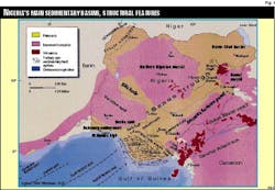
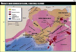
• and a lesser but not insignificant contribution from the unexplored onshore Benue trough (Fig. 1), part of the mid-African rift system, which has already proved to hold substantial oil reserves in the Doba basin of neighboring Chad.
This is the first of five parts on Nigeria’s oil and gas potential. The later articles deal with Niger delta oil reserves and production, Niger delta gas reserves, the delta’s deepwater region, and the Benue trough and onshore Cretaceous rift basins.
Setting
The Niger delta-Benue trough region is a 1,500 km long, 50-150 km wide, intraplate northeast-southwest tectonic megastructure filled with continental and marine sediments (up to 12,000 m in thickness in the Niger delta) that range in age from Neocomian to Quaternary.
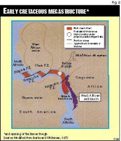
It is part of the mid-African rift system, whose origin is linked directly to the opening of the South Atlantic Ocean. More precisely, the genesis of this trough is connected to the opening of the Equatorial domain of the South Atlantic, which was initiated in latest Jurassic-early Cretaceous1 (Fig. 2).
An understanding of the West African margin must take into account the poly-phase development of the:
• rifting phase;
• ocean expansion phase.
The sedimentary evolution of the margin is characterized by three principal tectono-stratigraphic units:
A lower unit: continental rift phase (deposited on a pre-rift substratum), and
Middle and upper units (marine and deltaic): Ocean expansion phase.
All three units are separated by major unconformities.
Synrift deposits
The synrift deposits are made up of initial erosional products of structurally high areas, then the filling up of rift grabens by continental detritus and lacustrine deposits; a depositional environment important for excellent clastic reservoir development and rich organic source rocks.
The West African salt basin (Fig. 2) continental margin is floored by Precambrian metasediments, metamorphics, and igneous sequences. With the exception of the pre-rift sediments of the interior basin of the Congo, the oldest sediments found above the basement unconformity are of late Jurassic in age. These are the coarse basal sands and conglomerates of the Lucula and Vandji formations. The conglomerates include recognizable pebbles of basement rocks.
These coarse clastics are the preliminary erosional products that were deposited in the intracratonic basins that later developed into rift basins.
In the West African salt basin, this duality of continental and confined lacustrine sedimentation, ranges in age from Valanginian to early Barremian.
The top of synrift sedimentation is marked by a strong angular unconformity, which is certainly not synchronized over the length of the West African margin, and its development is dependent on local tectonic intensity.
The synrift deposits of the Niger delta complex proper have not been penetrated due to the thick, overlying post-rift sequences.
Marine sedimentation
For simplification, three principal episodes are recorded in the West African salt basin:
1. a pre-salt period of the Lower Aptian (synrift in Cameroon);
2. a salt depositional period of Upper Aptian age;
3. post-salt period beginning end-Aptian.
Margin evolution
The exact age of the first appearance of oceanic crust is not known. Partly because the lack of expansion synchronization along the length of the margin.
In southern Nigeria, during the transgressive Albian and early Turonian phases, shallow marine carbonates were deposited on relatively high structural elements onshore eastern Niger delta.
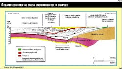
Fig. 3 demonstrates the position of the granite-basalt transition zone and its accommodation (through mantle collapse) for the Niger delta sedimentary sequence.
Cretaceous
On the West African salt basin margin, the first real marine sedimentation began at the end of Aptian time, with the establishment of a carbonate platform over the entire margin (with a tendency to lithologically “sharp” defined reefing on the outer borders in Angola). The internal platform facies is one of a very shallow water depositional environment, enabling the identification of an evaporite open area (salt) in Angola.
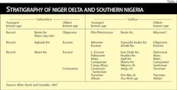
The oldest dated sedimentary rocks in Nigeria are the Lower Cretaceous (Albian) Asu River group of the Abakaliki and Anambra rift basins (of the Benue trough) as well as the Bima sandstones of the middle-upper Benue rift region. Older sediments may well exist beneath the Niger delta basin complex, formed as the Afro-South American continents first rifted and then spread apart (Table 1).
Asu River group is the initial clastic fill of the southern Benue rift, and consists of arkosic sandstones (Awi and Mamfe formations). Marine shales (Abakaliki shales) and limestones; and upper regressive sandstones of the Awe formation complete this unconformity bound sequence.
The Cross River group consists of shales, limestones, and sandstones of the Eze Aku and Awgu formations and the interbedded regressive sandstones of the Makurdi, Agala, Amasiri, and Agbani formations.
In the West African salt basin, generally, from the Cenomanian, the essentially carbonate facies is in a much more argillaceous environment, which continued into Paleocene times.
However, note the:
• deltaic periods in Angola: during the Turonian and Lower Senonian; in Gabon, during the Cenomanian and the Upper Cretaceous (successive paleo-deltas of the l’Ogoue).
• the Turonian carbonate period of Gabon.
Following the Santonian deformation period in Nigeria, deposition shifted westwards from the Abakaliki-Benue rifts to the Anambra basin. Paralic Enugu and Nkporo formations; the coal measures Mamu and Nsukka formations; and the fluvio-deltaic Ajali formation were laid down in the Anambra basin.
Tertiary, Quaternary
In the West African salt basin, the lower part of the Tertiary (Eocene-Oligocene) characterizes a period of sedimentary instability (numerous unconformities), especially during the Oligocene, which was accompanied by the development of major submarine channeling of the shelf slope.
As the margin subsided, a concomitant major marine transgression advanced from the east covering most of the basin by Early to Middle Miocene. Miocene deposition continued along most of the continental margin with several regressive episodes, during which a prograding depositional system occurred on the continental shelf.
At the beginning of the Tertiary, a marine transgression covered most of southern Nigeria, with the deposition of the Imo shale and terminating the development of the Cretaceous paleo-deltas. Early Eocene delta complexes formed in three separate depocentres, and elongate delta systems may have existed.
By Oligocene and certainly by Miocene times, the deltas had prograded and united to form a high energy constructive arcuate-lobate delta system which then rapidly prograded into deep water and extended onto cool transitional continental-oceanic crust. By Miocene times the delta complex had prograded onto cool oceanic crust, which had been generated as the African and South American lithospheric plates spread apart on the Gulf of Guinea and South Atlantic ridge-transform systems.
The Niger Delta
The Niger Delta is one of the world’s largest Tertiary delta systems and an extremely prolific hydrocarbon province.
Throughout its history, the delta has been fed by the Niger, Benue, and Cross rivers, which between them drain more than 10 million sq km of continental lowland savannah. Its present morphology is that of a wave-dominated delta, with a smooth seaward convex coastline transversed by distributary channels. From apex to coast the subaerial portion stretches more than 300 km, covering an area of 75,000 sq km.
Geologically, the delta sequence comprises an upward-coarsening regressive association of Tertiary clastics up to 12 km thick. It is informally divided into three gross lithofacies:
1. Alluvial sands, at the top;
2. Alternations of sandstones, siltstones, and claystones, in which the sand percentage increases up- wards;
3. Marine claystones and shales of unknown thickness, at the base.
Delta structure and stratigraphy are intimately related, the development of each being dependent on the interplay between sediment supply and subsidence rates. The dominant subsurface structures are syn- and post- sedimentary listric normal faults that affect the main delta sequence. They die out upwards into the alluvial sands and sole out at depth near the top of the marine claystones. Major growth-fault trends cross the delta from northwest to southeast, dividing it into a number of structural and stratigraphic belts, called depobelts, which become younger towards the south. The deltaic sequence in each of these depobelts is distinct in age, so that they actually represent successive phases in the delta’s history.
Hydrocarbons have been located in all of the sedimentary depobelts of the Niger delta in good quality sandstones belonging to the main deltaic sequence (the ‘paralic sequence’ of common usage). Most of the larger accumulations occur in roll-over anticlines in the hanging walls of growth faults, where they may be trapped in either dip or fault closures.
In the 40 years since the first discoveries were made, approximately 16 billion bblof oil has been produced, and a very substantial quantity of associated and nonassociated gas has been discovered. Most fields are small, though several larger fields contain recoverable reserves in excess of 500 million bbl of oil. The hydrocarbons are found in multiple pay sands with relatively short columns, and adjacent fault blocks usually have independent accumulations.
Strata, reservoirs
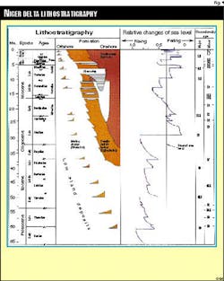
The Agbada formation overlies the Akata formation and consists mainly of alterations of sands, sandstones, and siltstones. The Agbada sands constitute the main hydrocarbon reservoirs of the delta (Fig. 4).
The sandstones are often poorly sorted, and grain size varies from fine to coarse. They are generally unconsolidated but can be slightly consolidated with calcareous cement. Lignite streaks and limonite are common; shell fragments and glauconite occur. The shaliness increases downward as the formation passes gradually into the Akata shales.
The Agbada formation generally consists of a series of offlap rhythms that range in thickness from 15-100 m. Rhythms begin with onlap marine sands laid down during a marine transgression. They are followed by marine shales as the offlap stage begins. Laminated fluviomarine sediments, laid down in a barrier foot environment follow. Barrier bar and fluviatile sediments succeed. They are often truncated by the next marine transgression deposits.
The Akata formation has proved to hold a great upside potential supplementing the prolific overlying Agbada. Thick, well-developed, deepwater turbidite sands are found interbedded within deepwater shales and were deposited during sea level lowstands.
Reservoir character
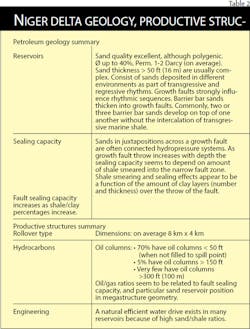
Most of the reservoir rocks of the Niger delta complex are present in the Agbada formation and are of excellent quality in the shallower sections.
• These porosities are commonly 28-40%, and permeabilities measured in darcies.
• Reservoir rock quality and geometry is strongly dependent upon depositional environment:
1. Pre-Miocene reservoirs deposited as widespread continuous sands, point bars, and channel sands.
2. Miocene to Holocene reservoirs probably deposited as barrier bars, less than 10 m thick.
• The multi-reservoirs in many fields are made up of superimposed reservoir rocks that were deposited in same or different environments.
The uppermost unit, the Benin formation, is mainly freshwater-bearing, massive continental sands and gravels deposited in an upper delta-plain environment, with local shale interbeds. The Benin formation is as much as 2,000 m thick; and the area of maximum thickness is coincident with that of the Agbada formation.
The sands and gravels of the Benin formation represent point-bar deposits, braided streams, channel fills, or natural levees, whereas the shales represent back-swamp deposits and oxbow fills. The sands and sandstones are coarse to very fine grained, very poorly sorted, sub-angular to round, and do not show lateral continuity.
The porosity of the sands is high, but the permeability is low. Although the continental Benin formation is generally fresh-water bearing, highly porous, and has few seals. A small number of oil fields, both on- and offshore, are in production.
Structures, oil traps
The Niger delta complex is characterized by long, regional synsedimentary (growth) faults, which have proved invaluable for hydrocarbon trapping.
The importance of these growth faults is such that most of the oil and gas discovered in the Niger delta are associated with structures formed as a direct result of syn-sedimentary tectonics.
The individual fields or groups of oil accumulations are delineated by large regional growth faults, or a series of closely spaced en echelon growth faults. The throw of these major regional faults is probably greater than 1,000 m.
The regional fault trends are parallel to the paleoshorelines and shelf edge. Because growth faults are syndepositional, their age decreases towards the present-day shoreline. The major regional growth faults that bound the productive trends updip expand the thickness of the downthrown time-equivalent section that produces within that trend.
Most of the traps in the Niger delta are anticlines produced by differential compaction and rollover strata on the downthrown block of regional growth faults. The fault generally does not provide the updip lateral seal but only the mechanism for trapping. Gentle undulations of the regional structural dip along the axis of the downthrown anticlines provide closure in directions parallel to the fault.
The large fields are on rollover anticlines immediately downthrown to the large regional growth faults. Many fault traps are also present on both upthrown and downthrown blocks. These consist of growth faults and antithetic faults in which the fault does provide lateral seal.
These traps are typical of U.S. Gulf Coast petroleum productive structures. In general, because of the southwest regional dip (seaward), most of the fields are in downthrown fault blocks. Shale diapiric structures are found predominantly in the offshore region.
Hydrocarbon types
Two basically different crudes are present in the Niger delta.
1. Light crude: paraffinic and waxy. Pour points in range of –7°C. to +32°C.
2. Medium crude (less than 26° API): naphthenic and non-waxy. Pour points generally lower than –25°C.
Waxy crudes are generally regarded to have been generated from terrigenous vegetable matter in non-marine source rocks. In general, the heavy, low-pour-point naphthenic crudes occur consistently above the lighter, high-pour-point paraffinic crudes.
A relationship can be argued between oil type and formation temperature. The dependence of the quality of the crude oil in the Niger delta on temperature rather than depth is demonstrated by the cluster of heavy, low pour-point oils in the cooler parts of the delta, whereas the lighter oils, with variable pour points above about –7°C., are found where subsurface temperatures are somewhat higher.
This could be due to the action of bacteria. The bacteria responsible for the chemical transformation, like other forms of life, survive only below critical temperatures, and Niger delta heavy crudes could have originated through bacterial transformation.
Geotemperatures
Generally, plots of subsurface temperature against depth and lithology show a distinct relation between temperature gradient and sand/shale ratio. In the Niger delta, the temperature gradient increases with diminishing sand percentage from less than 1.84° C./100 m (1.0°F./100 ft) in the continental sands of the Benin formation, to about 2.73° C./100 m (1.5° F./100 ft) in the Agbada paralic section, to a maximum of about 5.47° C./100 m (3.0° F./100 ft) in the continuous shale section, in the lowermost Agbada formation. Geothermal gradients also increase northward towards the basement areas, away from the centre of the Niger delta.2
Source rock modeling, and qualitative analysis of shale samples, shows the oil generative window to be between 2,200-7,000 m.3
Source rock quality
The volumes of oil and gas discovered in the Niger delta bears little relationship to the analytical results of source rock samples. Sample analysis has consistently shown source rock properties to be organically poor. It has been assumed that the most effective source rocks are the marine shales, and the shales interbedded with the paralic sandstones, particularly in the lower part of the Agbada formation, where at least the shales are of a volumetric significance.
Summary
The Niger delta region is the most important oil province in sub-Saharan Africa in terms of proven recoverable oil reserves, Libya being the largest in Africa.
The Niger delta in 1994 was the tenth largest world oil producer. In terms of oil field size distribution, fields are numerous and relatively small indispersed with medium sized and the occasional giant category accumulation. Oil reservoirs are typically stacked deltaic sand se- quences, and the principal reservoir-source unit is the diachronous Agbada formation.
Very little deep drilling has taken place in the delta, primarily due to geopressure considerations, but with the wide oil generative window, certainly productive Agbada and Akata sequences remain to be discovered at depth.
Away from the clusters of producing fields, large areas of the offshore delta region are immature in terms of petroleum exploration, and its overall exploration status is reminiscent of the Gulf of Mexico some 20 years ago. The deepwater delta region is a frontier area, but with the comfort compliment of a general understanding of the petroleum system in the shallower water depths, which can be extrapolated within the same delta complex into the deep.
Acreage availability
Most of the acreage in the Niger delta proper is held by major oil companies that have been in Nigeria since the beginning of oil exploration in the delta.
However, a number of indigenous Nigerian oil companies have been awarded prospective concessions under the recently introduced discretionary award scheme. Mareena Petroleum is such a company, and currently holds an ex-Shell permit in the onshore eastern delta region.
References
1. Maluski, H. et al., 40Ar/ 39 chronology, petrology, and geodynamic setting of Mesozoic to early Cenozoic magmatism from the Benue trough, Nigeria, Journal of the Geological Society, London, Vol. 152, 1995, pp. 311-326.
2. Ejedawe, J.E., Patterns of incidence of oil reserves in Niger delta basin, AAPG Bull., Vol. 65, No. 9, 1981, pp. 1,574-85.
3. Ejedawe, J.E., and Okoh, S.U., Prediction of optimal depths of petroleum occurrence in the Niger Delta basin, OGJ, June 8, 1981, pp. 190-204.
Partial bibliography
Amajor, L.C., and Gbadebo, A.M., Oilfield brines of meteoric and connate origin in the eastern Niger delta, Journal of Petroleum Geology, Vol. 15, No. 4, 1992, pp. 481-488.
Chukwu, G.A., The Niger delta complex basin: stratigraphy, structure, and hydrocarbon potential, Journal of Petroleum Geology, Vol. 14, No. 2, April 1991, pp. 211-220.
Egbogah, E. Onu, and Lambert-Aikhionbare, D.O., Possible new oil potentials of the Niger delta, OGJ, Apr. 14, 1980, pp. 176-184.
Ejedawe, J.E., and Okoh, S.U., Prediction of optimal depths of petroleum occurrence in the Niger delta basin, OGJ, June 8, 1981, pp. 190-204.
Ejedawe, J.E., Patterns of incidence of oil reserves in Niger delta basin, AAPG Bull., Vol. 65, No. 9, 1981, pp. 1,574-85.
Short, K.C., and Strauble, A.J., Outline of geology of the Niger delta, AAPG Bull., Vol. 51, No. 5, 1967, pp. 761-779.
Weber, K.J., Sedimentological aspects of oilfields in the Niger delta. Geol. en Minbouw, Vol. 50, No. 3, 1971, pp.559-576.
Weber, K.J., and Daukoru, E., Petroleum geology of the Niger delta, Proc. 9th World Petrol. Cong., Vol. 2, 1975, pp. 209-221.
Whiteman, A.J., Nigeria: its petroleum geology, resources and potential, Vol. 1 & 2, Graham & Trotman, London, 1982, 394 p.
Next: Niger delta oil reserves and production.
The Author
David Thomas is managing director of Mareena Petroleum Ltd., Lagos, which has exploration interests in Nigeria. He is a petroleum geologist with more than 20 years’ international exploration experience. After various assignments in Southeast Asia, North Sea, Libya, and Tunisia, he was chief geologist for the international division of Kuwait Petroleum Corp. until 1986. In 1987 he formed Thomas & Associates, a consulting firm specializing in basin studies in Southeast Asia and Africa. He is a graduate of the University of London.
