New Zealand's deepwater frontier becoming more realistic target
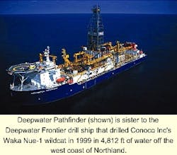
A new era in New Zealand petroleum exploration began in 1999 when Conoco's Deepwater Frontier drill ship spudded the Waka Nui-1 wildcat off the west coast of Northland. What makes Waka Nui-1 so important in New Zealand petroleum exploration is that this is the first well to step out beyond 1,000 m of water into New Zealand's undrilled and highly prospective deepwater frontier.
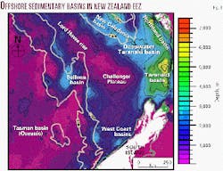
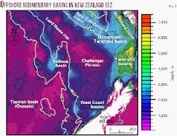
New Zealand, with about the same land area as Japan or the UK (c. 250,000 sq km), lies within a much larger submerged continent of around 3.5 million sq km. Much of this submerged continent contains sedimentary basins with inferred generative potential (Fig. 1), but the basins in more than 1,000 m of water-the deepwater frontier-were virtually unexplored until the 1990s.
New data acquired in the last decade have, however, improved our understanding of both the geological history and the petroleum potential of the deepwater frontier. Though a great deal more work is required to accurately assess this potential, preliminary interpretation of available seismic reflection data suggests that there is considerable scope for giant discoveries.
Deepwater geological history
A good understanding of New Zealand's tectonic development is vital when exploring the deepwater frontier because deformation associated with tectonism has had such a profound influence on the formation of prospective basins.
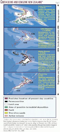
Tectonic reconstructions of the New Zealand region1 2 3 have used geological data as well as sea-floor spreading information to dismantle the present day geological jigsaw puzzle and realign these domains for periods of past time (Fig. 2). The clear picture from tectonic reconstructions is that the New Zealand of the past does not resemble the New Zealand of today.
The Cretaceous and Cenozoic history of New Zealand can be summarized as a Cretaceous and Early Tertiary rifted and passive margin, followed by a mid-Tertiary to Recent convergent margin. The corresponding sedimentary succession involves a 100 m.y. first-order transgressive-regressive "megasequence" characterized by a Cretaceous to Eocene transgression, an Oligocene condensed section, and Neogene regression and highstand. Up to 8,000 m of Cretaceous and Cenozoic sediments are recorded in New Zealand basins.
Most of New Zealand's deepwater basins were formed with the breakup of Gondwana in the Cretaceous. Rifting and subsidence during and after this time were accompanied by the deposition of coal measures within normal fault-controlled grabens. Cretaceous coal measures form the predominant source rocks in many New Zealand basins.
Marine inundation in the Late Cretaceous and Early Tertiary resulted in the deposition of shoreline and shallow marine sands and muds. Transgressive shoreline sands are the most productive reservoir rocks in New Zealand; they have excellent porosity and permeability and lie directly over source rocks. In the deepwater frontier similar paleoshoreline systems are expected to form good source rock-reservoir counterparts.
From the Early Tertiary, sedimentation patterns are characterized by a slow, persistent rise in relative base level that culminated in maximum marine inundation in the Late Oligocene. With progressive subsidence, marine silts, muds, and carbonates were deposited in most basins, including the deepwater frontier. These fine-grained lithologies form an effective cap rock and in Taranaki are the principal seal for the major fields.
From the mid-Tertiary the Australian/Pacific plate boundary developed through New Zealand. There was widespread uplift and erosion associated with convergent margin tectonism. Close to the plate boundary, deformation produced many anticlines and fault-bounded structural traps. Large volumes of sediment that were shed from rising mountain ranges in the North and South islands built out the continental shelf and poured down undersea canyons into deepwater frontier areas.
The Neogene overburden succession in most New Zealand basins is generally thick, mainly clastic, and regressive. Sandstone turbidites deposited in slope and basin-floor environments are common in many basins and form productive reservoirs in the Taranaki basin.
Deepwater exploration
Recently acquired geophysical data and the application of new prospecting techniques have helped to identify the petroleum potential of several deepwater sedimentary basins. These data include multichannel seismic reflection data, gravity, magnetic, swath bathymetry data, and sea-bottom dredge samples.
An example of a new prospecting technique used for mapping the New Zealand deepwater frontier is mathematical treatment of geophysical data to derive total sediment thickness. The method involves simultaneous inversion of satellite gravity, bathymetric, and seismic reflection data.4 The sediment and crustal thickness, interpreted from seismic data at key locations and the water depth around New Zealand, are used as constraints in a process that resolves the thickness of the sedimentary layer in remote areas. The method can be used for a preliminary assessment of frontier basins where there are only a few widely spaced seismic lines.
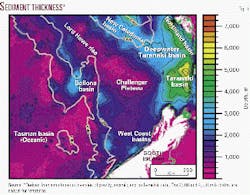
Results of the inversion process for a region west of New Zealand (Fig. 3) indicate the thick sedimentary successions in Taranaki and Northland extend westward into the Deepwater Taranaki basin and beyond into the New Caledonia basin. The inversion process also predicts that the Bellona and some West Coast basins may also have thick sedimentary successions.
New multichannel seismic reflection data have helped to "ground truth" tentatively identified sedimentary basins. Interpretation of the seismic data forms the basis for defining paleoenvironments and petroleum systems components-potential source, reservoir, and seal rocks. Present seismic coverage is limited to a few widely spaced lines tied to wells that are generally a great distance away. Some deepwater frontier basins have no multichannel seismic coverage at all and have yet to be surveyed in any detail.
The available geophysical and geological data, set within the overall New Zealand tectonic framework, are used to develop initial models of the petroleum maturation and accumulation conditions within frontier basins. Many assumptions are made in the development of these models so they are considered to be indicative of the petroleum potential of basins, laying the groundwork for further exploration rather than defining individual prospects.
One frontier basin where exploration is sufficiently advanced, so that a preliminary assessment of its petroleum potential can be made, is the Deepwater Taranaki basin.5 The basin's exploration history is an example of how the petroleum potential of New Zealand's deepwater frontier is being evaluated.
Deepwater Taranaki basin
The Deepwater Taranaki basin, along with the adjacent parts of Taranaki and Northland basins (in 1,000-2,000 m of water), covers an area of about 50,000 sq km. All of New Zealand's petroleum production currently comes from the Taranaki basin, making the neighboring deepwater region of particular interest because of the relatively close proximity of petroleum industry infrastructure.
Although the Deepwater Taranaki basin is close to the country's most explored and commercially successful hydrocarbon province, it remained largely undetected until the 1990s.
Inversion of gravity data suggested that a thick sedimentary succession occurred in the basin (Fig. 3), but until recently seismic coverage was restricted to a widely spaced grid of 1970s and 1980s vintage single-channel data. These data had insufficient penetration to image sediments below about 4,000 m (top of the oil window).
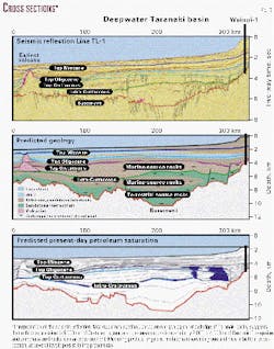
So the petroleum potential of the basin was not recognized until 1996, when the New Zealand government and the Australian Geological Survey Organisation acquired a high quality multichannel seismic reflection line (TL-1) through the area. Line TL-1 forms the basis for much of our present understanding of the geological history of the basin.
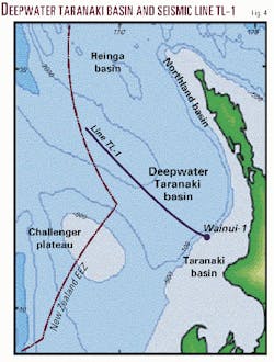
The seismic line TL-1 traverses the Deepwater Taranaki basin and into the Taranaki basin, where it is tied to the Wainui-1 exploration well (Fig. 4).
Interpretation of sedimentary facies and potential source rocks (Fig. 5) is principally based on our geological knowledge of Taranaki and information from dredge samples obtained around the perimeter of the deepwater basin. These data provide enough information for the tentative identification of potential kitchens, reservoirs, and seals. All these factors are combined in 2D basin modeling to predict petroleum generation and accumulation (Fig. 5) within the basin.5
It appears that basin formation began in the Cretaceous during rifting associated with the breakup of Gondwana. Early rift sediments are not seismically correlatable with the Taranaki basin but are interpreted as lateral equivalents of Taranaki basin source rock formations. In contrast to the Taranaki basin, where Cretaceous sediments are generally less than 3,000 m thick, the Cretaceous section in the Deepwater Taranaki basin appears to be greater than 5,000 m thick.
By the Early Tertiary, the area had subsided to bathyal depths. Cenozoic strata form a blanket of transgressive mudstones and carbonates across the basin. Neogene clastic sediments at the eastern edge of the basin derive from the uplifted and eroded New Zealand landmass.
The clastic content of the Cenozoic section appears to decrease westward, away from New Zealand to become almost purely pelagic in DSDP wells in the New Caledonia basin. Cenozoic strata are typically 2,000-4,000 m thick.
Basin modeling, using Taranaki basin lithologic properties, predicts that expulsion of petroleum began in the Late Cretaceous and continued into the Tertiary. Entrapment of petroleum occurred from the Early Tertiary when development of confining seals limited leakage.
The particular model shown here (Fig. 5) predicts significant quantities of petroleum are still trapped today, mainly at Cretaceous levels. The size of accumulations predicted from modeling is unconstrained because of the limited amount of data, but the model demonstrates the potential for giant discoveries in the Deepwater Taranaki basin.
Deepwater oil, gas potential
The total known area of New Zealand's deepwater frontier, with more than 3,000 m of sedimentary rock, is estimated to exceed 550,000 sq km.
Source, reservoir, and seal rocks occur in all New Zealand basins so far explored and are therefore expected in the deepwater frontier. Traps, both structural and stratigraphic, are also widespread. There is enough information about some of the better explored deepwater frontier basins to conclude that the fundamental geological parameters required for generation, migration, and entrapment of petroleum are present.
How much petroleum has been generated and trapped in the frontier basins? It is difficult to answer this question until more drilling is undertaken, but a rough estimate of the quantity of petroleum generated in New Zealand's deepwater frontier can be obtained by using volume estimates from the Taranaki basin.
Analysis of Cretaceous source rocks in Taranaki indicates that 26 million bbl/sq km of oil can be generated for each 100-m-thick section of source rock (at full maturity).
Should the deepwater frontier basins around New Zealand have similar source rocks, then applying the same generation rate as much as 24x1012 bbl of oil can be generated from the deepwater frontier.6 If less than 0.01% of this oil is trapped, the potential reserves can be measured in tens of billions of barrels.
Summary
Acquisition of new data has enhanced knowledge of New Zealand's deepwater areas to the point that a preliminary appraisal of the petroleum potential can now be made for some frontier basins.
Interpretation of existing data suggests that the prerequisites for petroleum expulsion and entrapment occur in some frontier basins and there is potential for large discoveries. Many frontier basins have yet to be explored, but the results from those basins undergoing evaluation are very promising.
With modern drilling technology New Zealand's deepwater frontier has never been more accessible for exploration and discovery.
Acknowledgments
This article is based on research funded by the Foundation for Research, Science and Technology. Underpinning this research are the data lodged by oil companies and research organizations with the New Zealand government. We acknowledge Crown Minerals of the Ministry of Economic Development for funding the preparation of this article and IES for the use of Petromod-2D (trademark) software.
References
- Walcott, R.I., "Geodetic strain and the deformational history of the North Island of New Zealand during the late Cainozoic," Philosophical Transactions of the Royal Society of London A321, 1987, pp. 163-181.
- Sutherland, R., "The Australia-Pacific boundary and Cenozoic plate motions in the SW Pacific: Some constrains from Geosat data," Tectonics, Vol. 14, No. 4, 1995, pp. 819-831.
- King, P.R., "New Zealand's changing configuration in the last 100 million years: plate tectonics, basin development, and depositional setting," in 2000 New Zealand Oil Exploration Conference Proceedings, Ministry of Economic Development, Wellington, 2000, pp. 132-146.
- Woodward, D.J., and Wood, R.A., "Bathymetry, sediment thickness and crustal structure from satellite gravity data," Exploration Geophysics, Vol. 31, Australian Society of Exploration Geophysicists, 2000, pp. 89-93.
- Stagpoole, V.M., Herzer, R., Funnell, R.H., and Uruski C., "Deepwater frontier basins of northwestern New Zealand-Burial history and hydrocarbon maturation," in 2000 New Zealand Petroleum Conference Proceedings, Ministry of Economic Development, Wellington, 2000.
- Uruski C., "Petroleum potential of New Zealand's deepwater basins," in 2000 New Zealand Petroleum Conference Proceedings, Ministry of Economic Development, Wellington, 2000.
The authors
Vaughan Stagpoole is a geophysicist with the Institute of Geological & Nuclear Sciences. He uses geophysical and geological data to understand tectonic processes involved in the formation and development of sedimentary basins. He is currently modeling heat flow, hydrocarbon generation, and fluid flow within sedimentary basins. He holds BSc (Hons.) and PhD degrees from Victoria University of Wellington. E-mail: [email protected]
Chris Uruski joined IGNS in 1987 and has worked on the petroleum geology of various regions of New Zealand. He specializes in the use of seismic interpretation as a tool for understanding the origin and development of sedimentary basins, their stratigraphic history, and structural evolution. He is a graduate of the University College of Wales, Aberystwyth.
