Oldest reservoirs of Cambrian, Permian lightly tested in Potwar basin, Pakistan
In Pakistan the first oil well was drilled near an oil seep at Kundal in the Potwar basin in 1866, just 7 years after the Drake well in Pennsylvania. Since then in spite of a low number of wells drilled, several oilfields have been discovered.
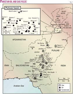
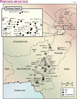
Yet the Potwar basin still has not acquired the status of a mature basin as all of its potential reservoirs either have not been reached or tested. Main production has been from Paleogene carbonate and Jurassic clastic reservoirs. The oldest reservoirs of Cambrian and Permian ages have been found in the "thrusted anticlinal play" of Adhi, Joya Mair, Dhurnal, Balkassar, Chak Naurang, Missa-Keswal, Rajian, and Kal oil fields (Fig. 1).
The recent commercial oil discovery in Permian Tobra sandstone in Missa Keswal-2 well by Oil & Gas Development Corp. Ltd. stresses the need for more concentrated effort on these older reservoirs, which either have not been reached or missed production tests in the first holes, as in Missa Keswal-1.
Potwar geology
The Potwar basin is bounded to the south by Salt Range escarpment, to the north by the Main Boundary Thrust, to the east by the Jhelum transform fault, and to the west by Kalabagh transform fault.1
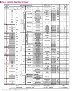
Infracambrian evaporites of unknown true thickness were deposited in the Potwar basin in restricted environments caused by carbonate banks developed over the east bank of the Jhelum re-entrant, north of present KalaChitta and Margala Ranges, along Precambrian basement lineaments which isolated Potwar from Kashmir and Hazara, where open marine conditions prevailed (Fig. 2).
Rocks of Cambrian age, collectively known as the Jhelum Group, are extensively exposed along the southern boundaries of the Kohat-Potwar basin in the Salt and Khisor Ranges and encountered in subsurface in the Potwar basin in several wells.2
The Jhelum Group represents different cycles of sedimentation beginning with mixed nonmarine and marine sandstone, and ending with the lagoonal Bhaganwalla/Khisor formation. Significant lithological change preceding and following the Cambrian makes the upper and lower contacts easy to recognize in the field, on wireline logs, and on seismic sections.
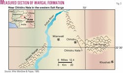
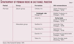
An Early Permian unconformity marks the onset of fluvio-glacial to glacio-marine/lacustrine conditions. The Permian rocks of the Salt Range and Trans-Indus Ranges are 610 m thick and can be further subdivided into two groups, the lower Nilawahan Group and the upper Zaluch Group, the former predominantly of continental origin, and the latter including marine rocks (Fig. 3 and Table 1).
Permian rocks have been encountered in several wells drilled in the Potwar basin.3 The base Permian unconformity is quite easy to pick on density-neutron logs, dipmeter logs, and seismic sections. The top Salt Range/Base Cambrian reflector is fairly strong and consistent. In general, Cambrian seismic facies are characterized by variable, locally high but normally low to moderate amplitude.
Top Tobra is a strong, consistent seismic reflector, especially in East Potwar, with low frequency and strong amplitude. Fig. 4 is a representative seismic section of Upper Indus/Potwar basin.
Adhi oil field
Pakistan Petroleum Ltd. discovered this field in East Potwar in 1978. It is a NE-SW trending, very narrow steep anticline, 64 by 12.8 km, with 610 m of vertical closure, eroded down to Mio-Pliocene Chinjis.
Adhi-5, drilled to 2,812 m, tested 50° gravity oil from Tobra sandstone, 44° gravity oil from Cambrian Khewra sandstone, and 27° gravity oil from Paleogene Sakessar limestone.
Chak Naurang oil field
OGDC discovered this field in the Potwar basin in 1986-87. It is reflected at the surface as an E-W trending narrow anticline covering 6.4 by 1.6 km with 305 m of amplitude, eroded down to Chinjis. At top Eocene level it is 7 by 1.75 km with 144 m of vertical closure.
It is associated with a major E-W thrust fault, and on trend with Karsal, Balkassar, and Joya Mair oil fields. In addition to the primary Eocene Chorgali limestone reservoir, it tested 19° gravity oil from Cambrian Khewra sandstone and Tobra sandstone.
Dhurnal oil field
Occidental Petroleum Corp. discovered this field in 1984 in the triangle zone in the foreland belt of the North Potwar Deformed Zone. At surface it is an E-W syncline, while at Paleogene and Permian subsurface levels it is an anticline with four-way dip closure, latter enhanced by faults.
The Dhurnal-2 well tested 3,500 b/d of oil from Permian Wargal limestone. There is little if any intergranular hydrocarbon storage. All hydrocarbons are stored in fractures, the latter providing the permeability through which the hydrocarbons are produced.
Missa Keswal oil field
OGDC discovered this field in East Potwar in 1991. It is a narrow NE-SW trending structure with surface expression 19 by 3.2 km, eroded down to Chinjis.
Missa Keswal-1 has been an oil producer from Paleogene Sakessar-Lockhart, Cambrian Jutana dolomite, Bhaganwalla, and Khewra sandstone (46° gravity). Cambrian Kussak had also tested positive. Tobra sandstone was not tested in this well.
Missa Keswal-2, drilled in 2002, tested commercial oil production from the Tobra sandstone reservoir.
Source rocks
Marine and restricted marine shales of the Paleocene Patala formation are the proven source rocks in the Potwar basin.
Based on weight percent organic carbon, estimated visual carbonization scale, and kerogen type, potential source rocks include shallow marine-estuarine shales of Chhidru (Late Permian) and Sardhai (Early Permian) and restricted marine shales of the Salt Range (Precambrian) formation. There are indications that hydrocarbons were generated in Khisor(?) (Cambrian) source rocks. Proven source rock Patala and potential source rock Salt Range are extremely rich sources for liquid hydrocarbons.
Permian-Cambrian reservoirs
The Permian, Chhidru, and Amb formations are mainly slope-forming, calcareous sandstones, while the Wargal formation is a cliff-forming massive carbonate unit.
Hydrocarbon Development Institute of Pakistan measured and sampled in detail a 123-m thick Wargal formation along the Chhidru Nala stream in the Western Salt Range.3 Based on the lithologic and biotic differences, the Wargal formation has been divided into seven lithologic units, which can further be divided into 11 microfacies, which were deposited in marine nearshore, intertidal, and shallow subtidal environments, with energy conditions ranging from moderate to high.
The important diagenetic processes recognized are bioturbation, micritization, dissolution, silicification, cementation, dolomitization, fracture fillings, chemical compaction, and secondary porosity development. A 10-m thick micritic dolomite unit is very distinctive and traceable over a long distance in the study area. This unit can be identified as a potential reservoir.
A geological and petrophysical study of cores from the Adhi-5, 10, and 11 wells by Core Laboratories4 has divided the Tobra formation into six lithofacies including sandstone, siltstone, poorly bedded sandstone, pebbly sandstone, sandy conglomerate, and bioturbated (argillaceous) sandstone.
These lithofacies form a thinly interbedded succession in which small scale fining upwards units can be recognized. These are believed to have been deposited within a shallow marine environment from short-lived density-turbiditic underflows, with fining upward units from waning flows.
Generally a glacial environment exists for Tobra, and the occurrence of ice rafted laminate facies in the Adhi-9 well probably represents glacial outwash sediments deposited into a marine basin. Reservoir characteristics include poor to moderate average porosity of 9.2% in Adhi-10 and 6.6% in Adhi-11, with geometric average permeability of 0.41 md and 0.49 md, respectively.
Three lithofacies are identified from Adhi-10 in the Cambrian Khewra formation. These are red colored, well-bedded sandstone, poorly bedded sandstone, and laminated rippled sandstone, considered to have been deposited as high energy braided stream deposits or as unconfined sheet flows accumulated in distal alluvial fan/sand flat environments.
Lateral continuity in adjacent wells and outcrops argues against considering deposition as a meandering channel system/point bars. Reservoir characteristics are poor to moderate, with average porosity 9.8% and geometric average permeability 2.79 md in Adhi-10. Well-bedded sandstone lithofacies at the top of the Khewra formation have the best reservoir quality.
Both the Tobra and Khewra formations are susceptible to formation damage through adverse reactions between certain sensitive minerals and particular drilling, completion, or stimulation practices. Diagenesis has had a significant effect, although it is subordinate to depositional texture as a control on porosity and to a lesser extent on permeability. Compaction is minimized in the Khewra formation by early precipitation of quartz overgrowth cements.
Recommendations
The prospectivity of the Potwar basin has been significantly enhanced by discoveries of hydrocarbons in the deeper Paleozoic reservoirs, as a result of more accurate delineation of subsurface structural crests by use of sophisticated seismic technology.
It is recommended to drill and test Paleozoic in general and Cambrian-Permian reservoirs in particular, especially in East Potwar where these reservoirs occur at shallower depths as a result of Mesozoic being eroded out. The time of hydrocarbon generation, migration, and the presence of suitable structural and stratigraphic traps need further study in search for oil in Cambrian-Permian reservoirs.
Although permeability and porosity decrease with depth, anomalously high values can occur at depth.5 The rate of permeability and porosity decline with increasing depth can be significantly reduced by grain coats and rims, early hydrocarbon emplacement, and shallow development of fluvial overpressure. Pre-drilling predictability can be attempted to assess such parameters.
References
1. Quadri, V.N., and Quadri, G.J., "Anatomy of success in oil and gas exploration in Pakistan,1915-94," OGJ, May 13, 1996.
2. Kadri, I.B, "Petroleum Geology of Pakistan," published by Pakistan Petroleum Ltd., Karachi, October 1994.
3. Cheema, A.H., "Microfacies Analysis and Porosity Development in Wargal Formation (Permian) Exposed at Chhidru Nala, Western Salt Range, Pakistan," SPE-PAPG Annual Technical Conference, October 1999.
4. Quest, Martin, "A Geological and Petrophysical Study of Cores from Wells Adhi 10 and 11," Core Labs, September 1990 (revised May 1991), OGDCL archives, Islamabad.
5. Bloch, S., et al., "Anomalously High Porosity and Permeability in Deeply Buried Sandstone Reservoirs," AAPG Bull., February 2002.
The authors
Mrs. V.N. Quadri ([email protected]) served Oil & Gas Development Corp. from its inception, retiring as acting general manager of exploration after nearly 30 years' service. She carried out several technical studies in collaboration with Russian, Norwegian, Canadian, and US geoscientists and visited China, Norway, Canada, the UK, and the US as Pakistani delegate to Unido, Norad, and Cida petroleum workshops. She has an MS in geophysical prospecting from the University of Michigan as a Fulbright-Smith Mundt scholar.
S.M.G. Jeelani Quadri has been regional manager of the public sector of OGDC. He was also exploration advisor to Marathon Pakistan Petroleum and Pakistan Shell Oil Co. After retirement from active exploration, he served in the oilfield equipment and services industry for about 10 years. He has a BSc in geological and physical sciences from Queen's University and an MSc in geological sciences from the University of Toronto.
