Exploration opportunities abound in Orphan basin off Newfoundland
NEWFOUNDLAND ORPHAN BASIN-1
The Orphan basin is a wide Mesozoic rift zone lying directly north and adjacent to the Grand Banks of Newfoundland.
The basin is the focus of an intense exploration effort by a consortium consisting of Chevron, ExxonMobil, Imperial Oil, and Shell Canada.
Although the basin is very large at 160,000 sq km, it has only seven wells, all drilled between 1974 and 1985.
Located in the shallow water part of the basin, these wells failed to discover hydrocarbons or to encounter the prolific Kimmeridgian source rock that is abundant in the neighboring Jeanne d’Arc and Flemish Pass basins, but they did prove the presence of Late Cretaceous and Tertiary reservoir rocks and organic-rich shales with source rock potential as discussed in this first part of a two-part article on the Orphan basin.
New seismic surveys, regional mapping, and correlation to adjacent basins indicate that the East Orphan basin has good potential to host an oil-rich petroleum system. The West Orphan basin is also recognized to have significant potential, with possible source rocks in the Cretaceous and Early Tertiary.
Regional trends would suggest that the West Orphan basin is more likely to be gas prone than oil prone, but the Early Tertiary shales are seen to have oil source potential. Numerous structural and stratigraphic traps have been identified in both basins.
While much of the East Orphan basin was licensed in the Canada-Newfoundland and Labrador Offshore Petroleum Board’s 2003 Call for Bids, a large amount of prospective acreage remains available in this basin, and no licenses have yet been issued in the shallower-water West Orphan basin.
Introduction
The Orphan basin is one of several lightly explored basins within the offshore area of the Canadian province of Newfoundland and Labrador.
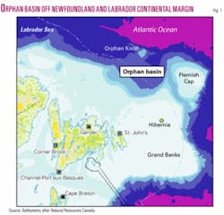
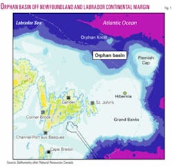
The basin takes its name from an isolated bathymetric high in 1,800 m of water known as the Orphan Knoll (Fig. 1) and has been referenced in whole or in part by other authors as the East Newfoundland basin and-or the Northeast Newfoundland shelf.
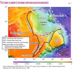
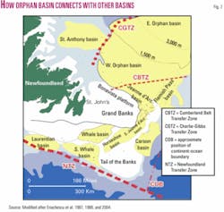
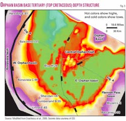
Herein the authors refer to the area outlined in as the Orphan basin, which is further subdivided into the West Orphan basin and East Orphan basin (Figs. 2 and 3) based on geological and bathymetric considerations.1-4
As defined here, the Orphan basin lies north of the Grand Banks bathymetric feature and is geologically connected to the better known Jeanne d’Arc and Flemish Pass basins. The Jeanne d’Arc basin is the only oil producing basin on the northwest Atlantic margin, and its oil production of 350,000 b/d is soon to increase to 440,000 b/d.5-7
The Orphan basin covers 160,000 sq km and is split between a shallow water (200-500 m of water) area to the west, an intermediate area (500-1,500 m) in the middle, and a deepwater area (1,500-3,000 m) to the east. The only drilling in the basin occurred during the mid-1970s to early 1980s exploration cycle, in which six shallow-water and one intermediate-water wells were drilled (Figs. 1, 3, and 4). These wells located on basement highs were dry holes.1 4 7
The eastern side of the Orphan basin recently attracted high bids for land parcels offered in the Canada-Newfoundland Offshore Petroleum Board’s (CNOPB) 2003 Call for Bids. Eight parcels totaling 5.2 million acres in a previously undrilled part of the basin went to a consortium consisting of Chevron 50%, ExxonMobil 25%, and Imperial Oil 25%, for a work commitment bid of $500 million (Fig. 4).
This was the most successful land sale in the history of the Canadian offshore and included a record bid of $188 million for one parcel.
The land sale had been preceded by large 2D speculative seismic surveys by Geophysical Services Inc. (GSI) and TGS NOPEC which showed that the basin contains several “Jeanne d’Arc basin-size” Mesozoic depocenters.1 4
Of particular interest to explorers is that correlation of the new data to adjacent basins indicates the presence of the Late Jurassic section, at least in the eastern half of the basin (named East Orphan basin by Enachescu et al., 2004).
As many readers may know, the Late Jurassic sedimentary formations include the source rock (Egret member) and one of the major reservoirs (Jeanne d’Arc sandstone) for the oil discoveries in the adjacent Jeanne d’Arc basin.
The present production consists of the combined output of Hibernia (940 million bbl recoverable) and Terra Nova (354 million bbl recoverable) fields in the Jeanne d’Arc basin, adjacent to and south of the Orphan basin. Late Jurassic sedimentary rocks are also recognized as being critical to the development of petroleum systems in the North Sea, Irish Sea, and other Atlantic margin basins.
The new data also show large structural antiforms within the Early Cretaceous and Late Jurassic sections, widespread fan-like features in Late Cretaceous and Tertiary successions, as well as several promising direct hydrocarbon indicators.1 4 8
Shell Canada recently joined the initial bidders and acquired a 20% interest in the blocks from ExxonMobil and Imperial Oil by farmout.
In addition to favorable geological conditions, the oil industry’s interest in the area is supported by commodity price increase and worldwide advances in drilling and development technology that allow for profitable field development of large deepwater fields in areas such as offshore Norway, Gulf of Mexico, Brazil, and West Africa.
Also, the success of the Hibernia and Terra Nova projects on the nearby Grand Banks has proven the technical and economic feasibility of oil developments in waters with seasonal iceberg traffic.6 7
Exploration history
Exploration of the Orphan basin commenced in 1969, when Shell Canada was granted a permit covering the western, shallow-water portion of the basin.
Other major oil companies held acreage in the basin throughout the 1970s and early 1980s, including Imperial Oil (Esso), Mobil, BP, and the former Texaco, as operators. Petro-Canada, Canterra, Beau Canada, Norcen, Columbia Gas, Home, Dome, Hudson’s Bay Oil and Gas, and others also participated as partners.
A number of exclusive and nonexclusive seismic programs were shot in the basin throughout the 1970s and early 1980s, resulting in over 50,000 km of 2D coverage, primarily focused in the shallow waters of the West Orphan basin. Seismic data quality, particularly below the base of Tertiary unconformity, was poor due to severe multiple problems, recording with short streamers, the greater thickness of the Tertiary section in the West Orphan basin (more than 4 km), and poor migration algorithms.
A Deep Sea Drilling Project (DSDP) hole drilled in 1970 on the Orphan Knoll (Fig. 2) showed the presence of Cretaceous and Jurassic sediments on the eastern flank of basin.10
The seven industry wells drilled on the western side of the basin between 1974 and 1985 were all located on large structural closures identified through mapping the base of Tertiary seismic marker, which was the deepest regionally consistent marker that could be correlated on the data available at the time.1 3 8 9
The play type tested in these wells was Cretaceous-Tertiary sediments draped over or flanking large rotated basement blocks. The wells typically encountered a thick Tertiary sequence overlying a relatively thin Cretaceous section before entering Paleozoic sediments, metasediments, and granite.
Although the Paleozoic is subject to active exploration in western Newfoundland and in other parts of eastern North America, it is generally considered to be economic basement in this area. This assessment could change with further exploration, as for example Ordovician carbonates on the Labrador shelf to the north have flow tested as high as 19 MMcfd of natural gas at Hopedale E-33 and 20 MMcfd at Gudrid H-55.
Good quality Late Cretaceous sandstone reservoirs encountered in the Linnet E-63 and Bonavista C-99 wells1 3 8 9 will be primary target zones throughout the Orphan basin along with expected early Cretaceous and Jurassic sands in the East Orphan basin.
As previously stated, six of the basin’s seven wells were in shallow water and targeted features lying close to the basin’s western margin or along the Cumberland Belt high (Figs. 3 and 4).
The Blue H-28 well, once a world water depth record holder in 1,486 m of water (TD 6,088 m), was located on the continental slope and tested a deeply buried Paleozoic rotated block. This well intersected Early Cretaceous sandstone with 19% porosity as determined from logs at 5,000 m.9 11
All of the wells intersected Late Cretaceous and Early Tertiary sequences with organic content ranging between 1 and 7%. The top of the oil window is at 3,100 m burial and can occur at drilling depths of up to 5,100 m subsea depending on water depth at the location.
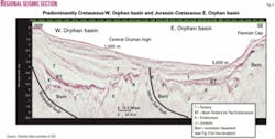
None of the wells penetrated the critical Late Jurassic section, which contains the recognized oil source rock for the Jeanne d’Arc and Flemish Pass basins to the south. However, the new 2D seismic lines show that the stratigraphy encountered in the existing wells is not representative of the large depocenters lying between the basement ridges, which very clearly include thick Cretaceous sections in the West Orphan basin and thick Jurassic/Cretaceous (and likely Triassic) sections in the East Orphan basin (Fig. 5).4 8
The possibility remains that the Jurassic may be present within some deep troughs and localized embayments in the West Orphan basin, but data resolution prevents any definitive conclusion to this effect.
Geologic setting
The Orphan basin represents an area of stretched and foundered continental crust that formed during a series of repeated rift episodes that lasted from the Late Triassic to the Tertiary and resulted in break-up of North America and the opening of the North Atlantic Ocean and Labrador Sea.4 7 12-21
Geologically, the basin is bounded to the west by the Bonavista fault, to the south by a possible transform fault marked by a series of high blocks known collectively as the Cumberland Belt Fault Zone (CBFZ), and to the east by a high basement ridge that runs between the Orphan Knoll and the Flemish Cap. To the north the sediments of the Orphan basin onlap against a basement high that extends west-southwest of the Orphan Knoll and the Charlie-Gibbs Fracture Zone (CGFZ, Figs. 2 and 3).1-3 12 13
The economic basement underlying the synrift and postrift sediments is Precambrian and Paleozoic in age and relates to the Appalachian orogeny. Paleozoic sequences are preserved as both sediments and metasediments throughout the Orphan basin as well on the Bonavista platform to the west. Where seismic data are of good quality it is possible to distinguish sedimentary stratigraphy from metamorphics and thus to consider underlying Paleozoic features as secondary targets.
Interpretation of GSI’s 2000-03 seismic grid indicates that the Orphan basin can be divided into two distinct Mesozoic basins, the West Orphan basin and the East Orphan basin, separated by the White Sail fault (Figs. 3 and 4).1-4 8
Fig. 5 is a cross-basinal seismic line that shows the western part of the basin as having a thick Tertiary cover above a synrift Cretaceous sequence that infills large grabens and thins against highly rotated basement blocks. On the eastern side of the basin, water is deeper, Tertiary cover is much thinner, and the synrift sequences include Late Cretaceous, Early Cretaceous, Jurassic, and possible Late Triassic sediments.
The Orphan high is a large promontory of 40,000 sq km with thin and very thin Tertiary cover that plunges southwest from the Orphan Knoll and breaks up into a series of ridges (Figs. 4 and 5).1 4 8
Seismic onlap of deep Mesozoic section against the central Orphan high suggests that it has existed since the Late Triassic, when extensional forces initiated crustal rifting in the area. Later extensional episodes have broken it into a series of large-scale north-south trending horsts and fault blocks, 10-15 km wide and 200 km long, that are seen in the present day structure (Fig. 4).
In the manner of the “Basin and Ranges” extensional style, the Orphan basin basement is arranged in parallel elongated troughs and ridges with predominantly NNE-SSW direction in the west and north-south direction in the east with small offsets along transfer faults. All major ridges are basement cored (horsts or rotated blocks) with synrift sedimentary cover that were formed by extension and later modified by transtensional forces.
White Sail fault
The Orphan basin was initially a Paleozoic sedimentary platform area that was affected by Permo-Triassic rifting only in its eastern part. The initial narrow rift was formed during Late Triassic-Early Jurassic within the Tethys rift system that spread from Gulf of Mexico to Barents shelf and Northern Europe.
After a long thermal subsidence stage, the newly formed rift basin was reactivated, enlarged, and matured during the Late Jurassic-Early Cretaceous Atlantic rifting phase.4 7 8 At that time, the East Orphan basin, bounded to the west by White Sail fault, was connected with other North Atlantic areas of source rock and reservoir deposition: the oil producing Jeanne d’Arc basin to south, the Flemish Pass basin to southeast (which has proven oil source rock and one noncommercial oil discovery in the Mizzen L-11 well drilled in 2003) and the petroliferous Porcupine basin to northwest.
The White Sail Fault Zone is a lengthy, large crustal fracture zone, characterized by en echelon segments separated by accommodation zones (Figs. 4 and 5). The fault originates in the Jeanne d’Arc basin, extends northerly, and then curves toward the Orphan Knoll, forming a tectonic boundary between the East Orphan and West Orphan basins.
A series of high basement blocks are located in the footwall (west side) of this fault, draped by thin synrift and postrift Tertiary cover.
As previously noted it is on the hanging wall (east side) of this fault that a significant thickness of synrift sediments including Late Jurassic-Early Cretaceous stratigraphic sequences accumulated and folded as large antiforms cut by secondary faults (Fig. 5). These features are the focus of current exploration in the basin.
Next: Source and reservoir potential and exploration risk and potential. ✦
The authors
Dr. Michael Enachescu ([email protected]) is Husky Energy senior fellow in exploration geophysics and associate professor at Memorial University of Newfoundland-Pan-Atlantic Petroleum Systems Consortium. He has over 30 years’ experience in oil and gas exploration and field delineation, mostly off Newfoundland and Labrador, the Scotian shelf and slope, Beaufort-Mackenzie basins, and various international areas. He did graduate studies in geology and geophysics at the University of Bucharest.
Phonse Fagan has been a petroleum geophysics consultant with the Newfoundland and Labrador Department of Natural Resources. He was appointed senior geophysicist with Vulcan Minerals Inc., St. John’s, in July 2005. He has more than 20 years’ experience in the oil and gas industry, including 5 years with Amoco Canada Petroleum Ltd. in Calgary. His work focuses on exploration in the province’s land and offshore basins and the use of seismic methods. He is also president of Petro-Ed, a St. John’s company that offers short courses to the oil and gas industry. He holds a BSc (Hons.) in physics and mathematics from Memorial University of Newfoundland.
Jerry Smee is a senior geophysicist with ExAlta Energy Inc., Calgary. He performed a regional seismic interpretation and assessment of Orphan basin hydrocarbon potential as a consultant with G&G Exploration Consulting. His 30-year career included 15 years as manager of Husky Energy Inc.’s Canadian frontier and international exploration group. Under his management Husky discovered and delineated White Rose field on the Grand Banks. He has worked most of Canada’s frontiers and Libya, Indonesia, Viet Nam, and China basins. He has a BS (Hons.) in geology and geophysics from the University of Alberta.
