Northeast gulf's James, Andrew exploration history outlined
Outer Continental Shelf hydrocarbon exploration of Lower Cretaceous carbonates began in 1968, with the James limestone and Andrew formation as targets. Six fields were declared in this carbonate trend: the James limestone formation's Viosca Knoll 252, Viosca Knoll 256 (terminated), Viosca Knoll 69, and Mobile 991 fields, and the Andrew formation's Main Pass 253 and Main Pass 221 relinquished fields.
Additional James shows are observed in wells on Viosca Knoll Block 114 and Viosca Knoll Block 117, which initially discovered James limestone gas during drilling to a deeper target. Relatively unexplored regions of Lower Cretaceous hydrocarbon potential occur on the Southern Platform in the De Soto Canyon/Florida Middle Ground areas, on the Sarasota arch, and in the South Florida basin adjacent to the Lower Cretaceous shelf-edge-reef-trend.
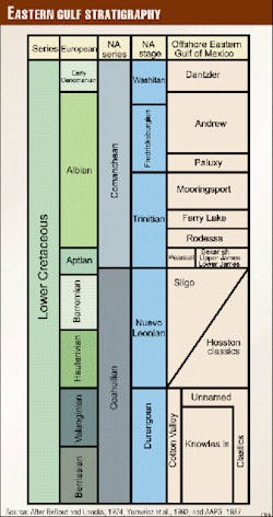
Stratigraphically between the Dantzler and Paluxy formations, the Andrew formation is composed of an upper Washita and two Fredericksburg aged carbonate platforms separated by shelf mudstones. The James limestone, comprising upper and lower members, dominates the thin shale members of the Pearsall formation.
Six facies compose the Lower Cretaceous carbonates where grainstone detritus zones, adjacent to reef/patch reef boundstones, were redistributed by wave action over the interior platform. Shelf mudstones, nearest the paleoshoreline, occurring in central and eastern portions of the Mobile and northern Viosca Knoll areas have no effective porosity.
Oolitic grainstones trend subparallel to the shelf-edge-reef trend and possess relatively more abundant spar cement destroying porosity. Reef/patch reef boundstones have micrite trapped in their growth structures resulting in poor permeability and interfinger with outer shelf mudstones nearest the shelf-edge.
Introduction
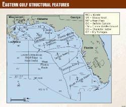
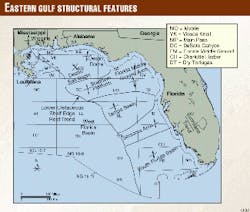
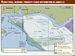
Exploration of the federal offshore Lower Cretaceous carbonate play began in 1968 when Chevron drilled the Main Pass 254 No. 1 well. To date the Lower Cretaceous carbonate consists of six declared fields and extends onto the Southern Platform, Sarasota arch, Tampa basin, and the South Florida basin (Figs. 1 and 2).
The Lower Cretaceous platform in the Eastern Gulf of Mexico is composed of interbedded carbonates, shales, and anhydrites and is 2,750 m (9,000 ft) thick and 200 km (125 miles) wide. A well defined rudist reef, classified as a rimmed platform, crests the shelf-edge and foreslope leading into open marine environments.1 Flanking the rudistid reefs are oolitic packstones and shelf grainstones adjacent and trending subparallel to shelf-edge boundstones and packstones. Updip are lagoonal and non-porous wackestones and mudstones interbedded with basinwide shales representing transgressive units.1 2 Anhydrites were deposited in the highly restrictive back-reef platform which was cut off from open circulation during highstand maximum development.3
Methods and purpose
Eighty-seven well logs were correlated using mud logs, induction logs, thin sections, photomicrographs, lithologic descriptions, core analysis, and paleontological reports from Minerals Management Service and industry operators. This report describes geological characteristics, facies relationships, and exploration history of the Lower Cretaceous Outer Continental Shelf carbonate rim margin and adjacent shelf areas.
Exploration model
Carbonate depositional environments were widespread throughout the Lower Cretaceous Gulf of Mexico providing analogs to other portions in the Gulf of Mexico. Although barrier reef complexes are important stratigraphic features along the shelf-edge, more prolific oil and gas fields have been discovered in patch reefs and debris mounds behind the shelf-edge-reef trend and, therefore, are more attractive targets for hydrocarbon exploration.4
Several authors have described the geology and exploration history of the Lower Cretaceous carbonates of the Gulf Coast/Gulf of Mexico with respect to Waveland, Poplarville, and Sunoco-Felda fields, the Brown dolomite zone of the Lehigh formation, Stuart City Trend, Black Lake field, Fairway field, JFS field, and the Golden Lane and Poza Rica trends.5-19
Fields within the Lower Cretaceous carbonate trend are characterized by developement of reefs and patch reefs on pre-existing structural highs. Reefs were subjected to secondary leaching activity in contrast to the surrounding low-lying areas.
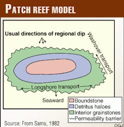
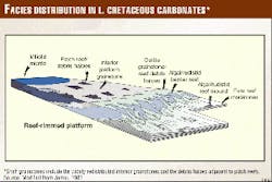
The patch reef consists of a central core of rudist boundstone surrounded by concentric deposits fashioned of grainstone and packstone bioclastic debris. The bioclastic debris is then surrounded by grainstones redistributed by wave action across the interior platform interfingering updip with lower-energy lagoonal mudstones or wackestones (Fig. 3). The grainstone/packstone patch-reef debris halo facies and the reworked interior platform grainstones facies hold the greatest exploration potential in the study area.4
Andrew limestone
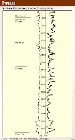
The Andrew limestone is a term used by operators to describe undifferentiated carbonates of Washita-Fredericksburg age and was first used by Eargle20 and described by Esther Applin21 in 1964 (Fig. 4). The section includes "pre-Dantzler rocks of the Washita and Fredericksburg Groups, undifferentiated" of Nunnally and Fowler.22 These rocks are composed of, in updip areas, gray to green shale, fine grained sandstone, and in downdip areas, of brownish gray sandy limestone and extend across southern Mississippi into adjoining states and the offshore. The designation of the Andrew limestone arose from the Gulf Oil Co. No. 25 J.M. Andrews well, in 6-1n-16w, Baxterville field, Lamar County, Miss.20 (Fig. 5).
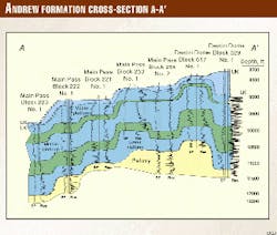
In federal waters of the Gulf of Mexico the formation consists of three carbonate platforms separated by gray carbonate mudstones, minor sands, and shelf shales of Washita-Fredericksburg age (Figs. 6 and 7). The Washita-aged upper platform is unconformably overlain by Upper Cretaceous sediments. It ranges in thickness from 130-490 ft and is composed of interbedded wackestones, debris packstones, boundstones, and dark brown to green shale.23 Fauna consist of rudists, bryozoans, gastropods, dasyclad algae, echinoids, stromatoporoids, brachiopods, miliolids, and coralline red algae. Zonal tops for the Washita platform are the foraminifer Lenticulina washitaensis and the ostracoda Fossocytheridea lenoirensis.24 25
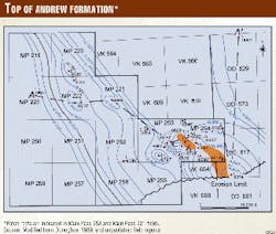
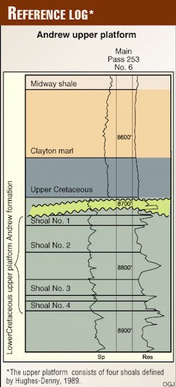
Hydrocarbons have been discovered in Main Pass blocks 221, 253, and 254 within the upper platform. Hughes Eastern defined four bio- strome shoals within the upper platform striking northwest-southeast within Main Pass 253 field (Fig. 8). These shoals interfinger with lower-permeability backreef mudstones updip and interfinger with reef boundstones downdip. Dolomitization took place along the shelf margin in a deeper freshwater-marine mixing zone that thinned updip where freshwater leaching of detritus zones occurred during subaerial exposure of the structural crest.26
The uppermost Shoal 1 is missing from wells in Main Pass 254 due to erosion. Main Pass 253 is structurally lower by 100 ft and therefore underwent more dolomitization than Main Pass 254. Shoal 2 is the primary reservoir for Main Pass 253 field, in which four wells encountered hydrocarbons 23-30 ft thick. A separate patch reef mound of Shoal 2 has two additional wells that show 18 ft of oil. A third separate patch reef contains 24 ft of oil. Shoals 3 and 4 exhibited no significant hydrocarbon shows.
The upper platform is separated from the middle platform by a mudstone that thins from 320 ft on the shelf to 50 ft at the shelf-edge. The middle platform is Fredericksburg in age and ranges from 500 ft in thickness at the shelf edge to 1,020 ft over the shelf. It is composed of boundstones, white to gray packstones/grainstones, and interbedded gray to black shales. The zonal top for the Fredericksburg platforms is the foraminifer Coskinolinoides texanus.21
A thick mudstone member 200-500 ft thick separates the middle platform from the lowermost platform. The lowermost platform is also Fredericksburg in age and is 400-450 ft thick. It consists of interbedded tan to white packstones/grainstones lying over siliciclastics of the Paluxy formation.
Exploration history
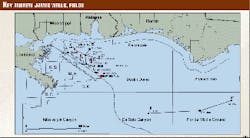
After the initial hydrocarbon well by Chevron on Main Pass Block 254 in 1968, 9 other exploratory wells were drilled by 1974, including those on Main Pass Block 253 OCS-G 1654 (Fig. 6).
In May 1972 a field was determined and the "A" platform was installed on Main Pass Block 254; by 1975 three additional production wells were drilled and tested. After cumulative production from wells A-1 and A-2 of 9,815 bbl of oil and 16.324 MMcf of gas, the leases were relinquished in June 1978.27
Tests indicated wells on Main Pass Block 254 were predominately oil productive and wells on Main Pass Block 253 were gas productive, further demonstrating a separation between the wells in these two lease blocks caused by erosion of Shoal 1 in the Main Pass Block 254 wells.
A second field 3 miles north of Main Pass 253 field was declared by MMS on the Main Pass Block 221 No. 1 well operated by Exxon in 1973 on the basis of a 59-hr production test. The test averaged 350 b/d, 70% water, 30% oil. Further testing determined the reservoir too limited to support installing a 40-mile plus pipeline. Exxon drilled Main Pass Block 220 and Main Pass Block 222, finding porosity but only small amounts of hydrocarbons. Wells drilled off-crest of the reef trend by Chevron and Exxon in Main Pass Block 252, Main Pass Block 254 No. 2, and Main Pass Block 223 No. 4 were abandoned (Fig. 6).
Chevron again leased Main Pass blocks 253 and 254 in 1982 but because of falling oil and gas prices farmed them out to Hughes Eastern Petroleum Inc. in 1986. Hughes Eastern drilled wells A-2 and A-3 on Main Pass Block 253 Lease OCS-G 5054 and A-1 on Main Pass Block 254 lease OCS-G 5055 with oil show tests in all three wells. Hughes Eastern never produced the wells, and the lease was terminated in 1994.
Regional exploration
After the initial disappointment of the Andrew formation in Main Pass 253 and Main Pass 221 fields, OCS carbonate exploration took on a regional flavor. Between 1977-84 Chevron tested Lower Cretaceous carbonates in the Viosca Knoll Block 30, Zapata in Destin Dome Block 617, and Shell in Destin Dome Block 529 and Main Pass Block 154, finding only minor amounts of hydrocarbons.
Success finally came in March 1986 when Tenneco, drilling through the Lower Cretaceous carbonates to a deeper target, encountered gas in sufficient quantities to warrant further exploration in the James limestone. Later that same year Shell drilled over the Southern Platform in De Soto Canyon Block 512, encountering 300 ft of porosity in the James limestone but no hydrocarbons.
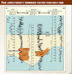
Regional porosity was confirmed over the Southern Platform by a second well drilled by Tenneco on Florida Middle Ground Block 455, which encountered 180 ft of 18% porosity with 25 md of permeability (Fig. 9). Chevron drilled Viosca Knoll blocks 169 and 296 in 1990 and 1993, respectively, encountering no hydrocarbons, in an effort to confirm the James gas show in Viosca Knoll Block 117.
James limestone exploration
Viosca Knoll Block 252 received the first James field designation in May 1994 (Fig. 2). The field is composed of Viosca Knoll blocks 252, 251, 296, 208, 207, and 253. Viosca Knoll 256 field, associated with a salt diapir, received the second field designation in September 1994 on Samedan's lease block Viosca Knoll 212 Well No. 1 but was later terminated.
First production in the James was in May 1998 in Viosca Knoll 69 field. It was followed by production in Mobile 991 field in July 1998; Chevron is designated as operator of both fields. Natural gas pays range from 15-121 ft in the James limestone offshore. Initial production of 15 MMcfd in Viosca Knoll 69 field has been reported.28
James limestone fields nearest the offshore production are found in the Mississippi Interior Salt basin and have only one well in the field producing. Poplarville, Sandy Hook, West Sandy Hook, Tylertown, East Morgantown, Dexter, Greens Creek, and Hub fields are associated with salt-cored anticlines with minor faulting.7
Porosity zone thickens onshore over the anticlinal crests of these fields with patch reefs common in Poplarville and Hub fields and grainstone shoals common at Sandy Hook field; the Bexar shale acts as the seal.7 Eight lithofacies were identified in the onshore James fields with the requinid/coral packstones, grainstones, and boundstones having the pay zones.7
James limestone stratigraphy
The Pearsall formation consists of three members: the uppermost Bexar shale, the James limestone, and the basal Pine Island shale. A poorly-developed, 10 ft thick Bexar shale member, comparable to thicknesses encountered in the Mississippi Interior Salt basin,7 is found in federal waters. The Pine Island shale member found onshore in the Pearsall formation is a carbonate in the offshore indistinguishable from the James limestone lithologically. Offshore James limestone and Pine Island shale members are commonly identified by operators offshore as upper and lower James limestone.
Six facies occur within the offshore James limestone interval: shelf lagoonal mudstones, found in central and eastern Mobile Area; interior platform grainstones found in western Mobile and Viosca Knoll areas; grainstone debris haloes adjacent to reef structures; reef and patch-reef rudist boundstones located in western Mobile, Viosca Knoll, De Soto Canyon, and Florida Middle Ground areas; oolitic belt grainstones adjacent to the shelf-edge reef trend, and forereef mudstones in the off-shelf Main Pass area (Fig. 10).
Shelf lagoonal mudstones were subarealy exposed, eroded, and redistributed across the platform interior. Wave action washing over debris haloes surrounding reef/patch reefs were also redistributed across the platform interior. As in the case with the Andrew formation, the updip portions of the interior platform were exposed removing mud and spar cement enhancing porosities in the grainstone facies. Oolitic belt facies, found in the deeper portions of the platform adjacent to the reef trend, may not have been subarealy exposed to flush out the porosity destroying mud and spar cement in submergent areas of the platform.
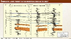
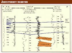
Wells drilled on Mobile 991 encountered two zones of porosity in the James limestone with the No. 1 well of lease OCS-G 15403 having tested for gas (Fig. 11). These two porosity zones extend to neighboring wells drilled in western Mobile and Viosca Knoll areas and demonstrate regional interior platform porosity zones that are correlative behind the shelf-edge reef trend (Figs. 11 and 12). Wells along the shelf edge encounter zones of porosity that exceed 300 ft where reef detritus zones contribute to the local porosity thicknesses. Exploration by Chevron of Viosca Knoll Block 390, near an interior shelf edge, encountered 100 ft of porous limestone but flowed only formation water. Wells drilled in central and eastern Mobile Area are in a nonporous micritic facies and would not be a target in the James limestone (Fig. 13).
Future exploration areas
Porosity zones have occurred along the shelf-edge adjacent to basement highs and salt cores that allowed for extensive reef and patch reef growth. Such areas are the Wiggins arch of southern Mississippi, Mobile plain of western Mobile and Viosca Knoll areas, Southern Platform of the De Soto Canyon and Florida Middle Ground Areas, and Brown dolomite zone of the South Florida basin.
Drilling along the Southern Platform has encountered porosity zones in the James. Formation depths more than 3,000 ft shallower than those in the Viosca Knoll/Mobile areas make drilling cost less and the target more attractive.28 Wells drilled in the Destin Dome and Pensacola areas did not encounter any James limestone hydrocarbons or large porosity zones.
The South Florida basin's Sunniland trend covers an onshore area of 742,400 acres on its eastern side. Discovered in 1943, Sunniland oil field, Collier County, Fla., was the first of 14 onshore fields that have collectively produced over 100 million bbl of oil equivalent.
The Sunniland formation is not currently productive in federal waters but has been penetrated by seven wells.
Federal waters exploration of the South Florida basin began in 1960 when the Dry Tortugas Block 519 Well 1 (OCS 28) was drilled, encountering a minor show at 12,345-12,685 ft with a porosity of 20%. Drilling resumed in February 1981 by Tenneco in Charlotte Harbor Block 672 that also encountered a minor hydrocarbon show.
Later that year, four additional wells in the Charlotte Harbor and Vernon Basin areas were drilled along the Sarasota arch in hopes of extending the Sunniland trend offshore onto the adjacent basement high. A seventh well drilled in 1986 by Shell Offshore Inc. in Charlotte Harbor lease Block 622 was also unsuccessful.
These wells have drilled the Brown dolomite zone of the Lehigh Acres formation, whose stratigraphic equivalent is the James limestone, encountering porosity and minor shows of hydrocarbons. The James limestone and Brown dolomite zone occur just above the zonal top of the foraminifer Choffatella decipiens and below the anhydrite beds of the Punta Gorda formation and Ferry Lake/ Rodessa formations.3
Conclusions
Patch reefs with reservoir quality rock are a demonstrated target in the James limestone (Aptian) and the Andrew formation (Albian) near the shelf-edge and adjacent shelf areas.
Porosity was enhanced by subareal exposure of patch reefs that created a detritus grainstone halo around less permeable reef boundstones and by redistribution of interior platform grainstones through wave action away from the patch reefs. Submergent areas of the platform may not have spar cement and mud removed by flushing as did updip subarealy exposed portions of the platform.
Six lease blocks have achieved field status by the MMS: the Andrew formation's fields Main Pass 253 and Main Pass 221; the James limestone's fields Viosca Knoll 252, Viosca Knoll 256, Viosca Knoll 69, and Mobile 991. In addition two lease blocks have notable gas shows in the James limestone: the discovery well in Viosca Knoll Block 117 and the borehole in Viosca Knoll Block 114.
Regional structural highs favorable for patch-reef development in addition to the Mobile/Viosca Knoll areas would be the rim margin adjacent to the Southern Platform, Sarasota arch, and localized highs in the South Florida basin.
Acknowledgments
The author thanks the many colleagues at MMS who offered advice, especially Dave Cooke, Barbara Bascle, Mike Smith, George Franklin, and Leanne French for their review of the text; Gerald Marchese, Allan Linker, and Linda Wallace for drafting the illustrations; and MMS for permission to publish this study.
References
- Yurewicz, D.A., Marler, T.B., Moyerholtz, K.A., and Siroky, F.X., Early Cretaceous carbonate platform, north rim of the Gulf of Mexico, Mississippi and Louisiana, in Cretaceous carbonate platforms, J.A. (Toni) Simo, R.W. Scott, and J. Masse, eds., AAPG Memoir 56, 1993, pp. 81-96.
- Scott, R.W., Cretaceous carbonate platform, U.S. Gulf Coast, in Cretaceous carbonate platforms, AAPG Memoir 56, 1993, pp. 97-109.
- Petty, A.J., Ferry Lake, Rodessa, and Punta Gorda anhydrite bed correlation, Lower Cretaceous, offshore eastern Gulf of Mexico, GCAGS Transactions, Vol. 45, 1995, pp. 487-493.
- Sams, R.H., 1982, Gulf Coast stratigraphic traps in the Lower Cretaceous carbonates, OGJ, Feb. 11, 1982, pp. 177-187.
- Baria, L.R., Waveland field: An analysis of facies, diagenesis, and hydrodynamics in the Mooringsport reservoir, GCAGS Transactions, Vol. 31, 1981, pp. 19-30.
- Sanness, T., and Minihan, E.D., 1979, Waveland field, a unique structural and stratigraphic trap, abs., GCAGS Transactions, Vol. 29, 1979, p. 187.
- Loucks, Robert, Able, Cole, and Ver Hoeve, Mark, 1996, Paleostructural association, lithofacies architecture, and reservoir quality of the Upper James lime (Pearsall fm., Lower Cretaceous) in the Poplar field, Pearl River Co., Miss., GCAGS Transactions, Vol. 46, 1996, pp. 235-248.
- Tyler, A.N., and Erwin, W.L., Sunoco-Felda Field, Hendry and Collier counties, Florida, AAPG Reprint Series No. 23, 1976, pp.146-158.
- Applegate, A.V., Part II-The Brown dolomite zone of the Lehigh Acres formation (Aptian) in the South Florida basin-A potentially prolific producing horizon offshore, State of Florida Department of Natural Resources, Info. Circ. No. 104, 1987, 66 p.
- BeBout, D.G., and Loucks, R.G., 1974, Stuart City Trend Lower Cretaceous, South Texas-A carbonate shelf margin model for hydrocarbon exploration, Bureau of Economic Geology Report of Investigations No. 78, 1974, pp. 59-76.
- White, B.R., and Sawyer, J.R., Black Lake field-before and after, GCAGS Transactions, Vol. 16, 1966, pp. 219-225.
- Herrman, L.A., Lower Cretaceous Sligo reef trends in central Louisiana, GCAGS Transactions, Vol. 21, 1971, pp. 187-198.
- White, B. Ross, Black Lake field, Natchitoches Parish, La., AAPG Memoir 16, 1972, pp. 481-488.
- Bailey, Jonas, Black Lake field Natchitoches Parish, La.: A review, GCAGS Transactions, Vol. 28, 1978, pp. 11-24.
- Fox, B.W., How many James reef pools lie hidden in Fairway region, OGJ, June 10, 1963, pp. 246-252.
- Terriere, R.T., Geology of Fairway field, East Texas, North American oil and gas fields, AAPG Memoir 24, 1979, pp. 157-176.
- Pollard, C.D., Regional depositional framework of the Lower Cretaceous James limestone and its relationship to hydrocarbon accumulations in East Texas, unpublished master's thesis, Baylor University, 1985, 160 pp.
- Jacka, Alonzo D., and Stevenson, J.C., The JFS field, Dimmit County, Texas: Some unique aspects of Edwards-McKnight diagenesis, GCAGS Transactions, Vol. 27, 1977, pp. 45-60.
- Coogan, A.H., Bebout, D.G., and Maggio, C., Depositional environments and geological history of Golden Lane Trend, Mexico, an alternate view, AAPG Reprint Series No. 23, 1972, pp. 159-187.
- Eargle, D.H., 1964, Surface and subsurface stratigraphic sequence in Southeastern Mississippi, Geological Survey Professional Paper 475-D, Article 130, 1964, pp. D43-D48.
- Applin, P.L., and Applin, E.R., The Comanche Series and associated rocks in the subsurface in central and South Florida, USGS Professional Paper 447, 1965, 82 p.
- Nunnally, J.D., and Fowler, H.F., Lower Cretaceous stratigraphy of Mississippi, Mississippi Geological Survey Bull., 1954, 43 p.
- Reed, J.C., Main Pass 253 field, unpublished internal MMS report, 1973.
- Petty, A.J., Lower Tuscaloosa clastic facies distribution (Upper Cretaceous), federal and state waters, eastern Gulf of Mexico, GCAGS Transactions, Vol. 47, 1997, pp. 451-462.
- MMS, Biostratigraphic chart, Department of the Interior, Minerals Management Service, Gulf of Mexico OCS Region, 1996.
- Hughes-Denny, Main Pass 253 field, unpublished report, 1989.
- Seni, S.J., Hentz, T.F., Kaiser, W.R., and Wermund, E.G., Atlas of northern Gulf of Mexico gas and oil reservoirs, Vol. 1 Miocene and older reservoirs, Bureau of Economic Geology, The University of Texas at Austin, 1997, 199 p.
- Kerr, D., Chasing gulf carbonates, Hart's Oil and Gas World, October 1998, pp. 43-45.
Bibliography
Donoghue, W., Reserve field files, Main Pass 253, U.S. Department of the Interior, Minerals Management Service, Office of Resource Evaluation, New Orleans, 1989.
James, Noel P., Reef environment, in Carbonate depositional environments, Peter A. Scolle, Don G. BeBout, Clyde H. Moore, Eds., AAPG Memoir 33, 1983, p. 439.
AAPG, Correlation of stratigraphic units of North America (COSUNA) project, Gulf Coast region, P. Huddleston, J. Braunstein, and R. Biel, coordinators, correlation chart series, AAPG, Tulsa, Okla., 1987.
The Author
Andrew J. Petty has worked for the Minerals Management Service for the last 20 years in the rate control section and as district geologist in the Corpus Christi District Office. Currently he works in Resource Evaluation's basin analysis section where he is involved in National Assessment, Offshore Atlas Project, and has authored several papers on Mesozoic stratigraphy of the eastern Gulf of Mexico. E-mail: [email protected]
