Lampasas gets first commercial field with Strawn gas in Fort Worth basin
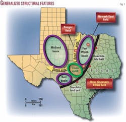
The Fort Worth basin was noted for prolific oil and gas production long before the discovery of Newark East field in 1981 and the extensive Barnett shale gas play (Fig. 1).
In 1917, the discovery of Ranger field stimulated one of the largest exploration and development drilling “booms” in Texas.1 Ranger field produces from the Atoka-Bend formation, a sandstone-conglomerate reservoir that directly overlies the Barnett formation.
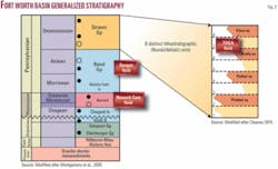
Operators drilled more than 1,000 wildcat tests in and around the Fort Worth basin attempting to duplicate the success of Ranger field. These wildcat efforts resulted in the discovery of more oil/gas fields and production from numerous other reservoirs including Strawn fluvial/deltaic sandstone, Atoka-Bend fluvial/deltaic sandstone and conglomerate, Marble Falls carbonate bank limestone, Barnett siliceous shale, and Ellenburger dolomitic limestone (Fig. 2).
While most companies are concentrating on the Barnett gas play, Scully Energy Corp., private Salado, Tex., independent, focused on the productive reservoirs above and below the Barnett. Scully Energy in mid-2006 discovered an important gas field, TOGA (for Texas Oil and GAs), in southeastern Lampasas County, Tex. TOGA field produces from two of multiple Strawn reservoirs and has 55-65 bcf of gas or more recoverable by the first author’s estimate.
TOGA is the first commercial oil or gas field in Lampasas County.
In addition to the Strawn reservoirs, Scully Energy encountered significant oil and gas shows in the Atoka-Bend, Marble Falls, and Ellenburger formations. Subsequent geological work indicates potential traps and the possibility for additional new discoveries.
Drilling history
Scully Energy’s interest in the southern part of the Fort Worth basin is the result of two key wells drilled in 1918 and 1949.
The 1918 well, New York Syndicate/Tienert No. 1, is one of the 1,000-plus wildcat tests drilled in an effort to extend the Ranger Atoka-Bend play to the south along the southeastern flank of the Bend arch. Tienert-1 encountered oil shows in the Marble Falls and Ellenburger formations at 3,400 ft. Records indicate the “well penetrated a 30 foot oil bearing zone and showed considerable oil and much gas.” However, the Tienert-1 well was deemed noncommercial and was plugged.
The 1949 well, Susman/Gotcher No. 1, was drilled to 1,450 ft and penetrated only the upper portion of the Strawn section.
Records indicate a shut-in gas well from the Strawn reservoir that tested 2 MMcfd of gas. The well was eventually plugged due to lack of a gas market and infrastructure.
The TOGA field discovery well, Scully/Gotcher No. 1, was drilled offset to the Susman/Gotcher-1 well.
Scully Energy was drilling TOGA field’s seventh well as this article went to press, and one well is within a few hundred feet of the Coryell County line. Three wells have been placed on 72-hr tests, and the start of gas production awaits installation of a 6-mile pipeline along right-of-way as yet not selected.
Geological setting
TOGA field is located on the Lampasas arch at the juncture of the south Fort Worth basin, the western edge of the Ouachita fold belt, and the northeast flank of the Llano uplift (Fig. 1). All three structural features are important components to the development of the TOGA field reservoir and trap.
The Fort Worth basin is classified as a foreland basin associated with the Ouachita orogeny. The Ouachita orogeny is a major thrust fold belt that began during the Mississippian and continued throughout the middle to late Pennsylvanian.2
The resulting Fort Worth basin is a north-south elongated trough that is parallel and bounded by the Ouachita fold belt on the east, bounded on the west by the Bend Arch, and bounded by the Llano uplift to the south.3 The Strawn sediments in the Fort Worth basin were derived from the rising forelands of the Ouachita fold belt.
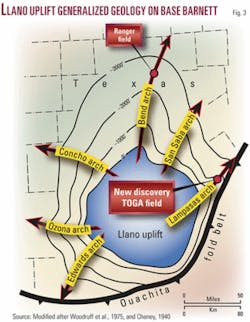
The Llano uplift occurred during Pennsylvanian time and is also associated with the Ouachita orogeny (Fig. 3). The Llano uplift is ovate in shape and is structurally complex with numerous faulting and structural folding or arches that developed in a radial pattern around the uplift. It is along these arches where major oil and gas fields have been discovered, such as Ranger field and subsequently TOGA field.
Strawn deposition
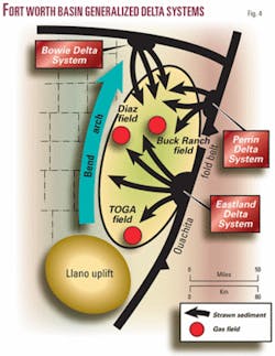
Three major delta systems dominated Strawn deposition in the Fort Worth basin (Fig. 4).4
Depositional thickness of the Strawn sediments ranges from 4,500 ft in the north part of the basin to 1,500 ft in the southern part of the basin. The Eastland Delta system filled the south Fort Worth basin and is associated with numerous oil and gas fields, including TOGA field.
The westerly prograding Eastland Delta system deposited Strawn sediment from the rising Ouachita fold belt into the Fort Worth basin. The orogeny of the Llano uplift and subsequent Lampasas arch were contemporaneous with Strawn deposition and controlled the accumulation of the sediments.
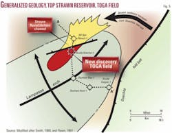
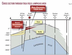
The Strawn sediments were funneled and deposited along the north flank of the Lampasas arch (Figs. 5 and 6). Surface geology2 corroborates the depositional direction from the Ouachita fold belt. The Llano uplift acted as a barrier to the southwest where the Strawn sediment thins appreciably.
Strawn stratigraphy
Previous detailed subsurface work indicates eight distinct lithostratigraphic units throughout Strawn deposition in the Fort Worth basin (Fig. 2).4 5
The Strawn sediments are related to fluvial-deltaic and fan-delta systems. Each lithostratigraphic unit represents a depositional cycle of the progradational delta. All eight depositional cycles are recorded in the northern part of the Fort Worth basin, whereas only four of the depositional cycles are noted in the southern part of the basin.
The initial TOGA field Strawn reservoir, termed the “Cisco,” is associated with the last unit or depositional cycle. The “Scully” Strawn reservoir (Unit 6) is also productive and is waiting production testing. The last two units, “Parker” and “Preston,” are prospective and have excellent production potential.
Strawn trap and reservoir
The trap for TOGA field is a combination stratigraphic and faulted anticline (Figs. 5 and 6).
This type of trap is most common in the Strawn reservoirs of the Fort Worth basin and is also associated with the largest Strawn fields.4
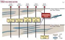
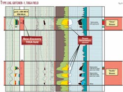
The Strawn reservoirs are classified as fluvial/deltaic sediments and were deposited in a shallow basin environment.5 The log profiles of the Strawn reservoirs from TOGA field wells exhibit the type of geometry from a fluvial/deltaic system and are more specifically interpreted to be delta front facies and distributary channel sands (Fig. 7).
The reservoirs of Diaz (Erath County, 1971) and Buck Ranch (Parker County, 1975) fields are analogous to the reservoirs of TOGA field (Fig. 4). The reservoir of Diaz field is from the Eastland Delta System, and the wells produce 1+ bcf from a 25-30-ft zone. The reservoir of Buck Ranch field is from the Perrin Delta System, and those wells produce 600+ MMcf from a 15-20-ft zone.
The TOGA Strawn reservoir is fine-medium grained sandstone with a porosity of 15-20%. The thickness ranges from 30 to 80 ft (Fig. 8). The dominant drive mechanism for the Strawn reservoirs in the Fort Worth basin is solution gas. It is assumed the drive mechanism for TOGA field will also be solution gas.
Reserve analysis for the Cisco Strawn reservoir indicates a recoverable 35+ bcf. The Scully Strawn reservoir is waiting on testing, but preliminary estimates indicate a recoverable 20-30+ bcf.
References
- Matteson, W.G., “A Review of the Development in the New Central Texas Oil Fields During 1918,” AAPG Bull., Vol. 3, No. 1, 1919, pp. 63-211.
- AbdelWahab, M.M., “Stratigraphy of the Strawn (Pennsylvanian), Colorado River Valley, North-Central Texas,” unpublished master’s thesis, University of Texas, 1980.
- Montgomery, S.L., et al., “Mississippian Barnett Shale, Fort Worth basin, north-central Texas: Gas-shale play with multi-trillion cubic foot potential,” AAPG Bull., Vol. 89, No. 2, 2005, pp. 155-175.
- Cleaves, A.W., “Upper Desmoinesian-Lower Missourian Depositional Systems (Pennsylvanian), North-Central Texas,” unpublished PhD dissertation, University of Texas, 1975.
- Wandling, D.E., “The Geometry and Stratigraphic Relationship of Fluvial/Deltaic and Shallow Marine Facies in the Upper Part of the Upper Strawn Group (Pennsylvanian),” unpublished bachelor’s thesis, Baylor University, 1984.
Bibliography
Cheney, M.G., “Geology of North-Central Texas,” AAPG Bull., Vol. 24, No. 1, 1940, pp. 65-118.
Flawn, P.T., et al., “The Ouachita System,” University of Texas Bureau of Economic Geology Pub. No. 6120, 1961.
Smith, S., “The Stratigraphy of the Travis Peak Formation across the Lampasas Arch, Central Texas,” unpublished bachelor’s thesis, Baylor University, 1980.
Woodruff, C.M., et al., “Lineaments of Texas-Possible Surface Expressions of Deep-Seated Phenomena,” Geothermal Resource Assessment for the State of Texas, University of Texas Bureau of Economic Geology, 1984.
The authors
John Sobehrad ([email protected]) is an independent geological/geophysical consultant and owner of the company Geo-Logic. He began his career in the late 1970s and has held various positions from wellsite geologist to chief exploration geologist and president. His experience has been onshore in Texas, Oklahoma, Louisiana, Mississippi, Montana, North Dakota, and Morocco. Offshore experience includes the Gulf of Mexico and the Atlantic basins of Morocco. He has BS in geology from the University of Wisconsin-Eau Claire.
Ralph Dozier is a geophysicist and owner of Intrepid Exploration & Production Co. He began his career in 1952 working for Precision Exploration Co. on a seismograph crew in the Williston basin, Permian basin, South Texas, and the Gulf Coast. In 1961, he became chief geophysicist for Cabot Corp. and worked worldwide. In 1975, he became director of domestic geophysics and later exploration manager for Union Texas Petroleum. In 1984, he began work as a consultant for Edwin L. Cox Co. in Corpus Christi. He majored in geology at the University of Houston.
