Swan Creek field: Isolated success or tip of the iceberg?
Swan Creek field operated by Tengasco Inc. in northeastern Tennessee consists of more than 40 wells capable of production, most of which yield gas and several of which make oil.
Gas production is mostly from the Knox Group, and oil production is mostly from the Stones River and Trenton Groups.
The field is localized in a complexly faulted anticlinal structure beneath the Clinchport thrust sheet. Primary porosities that range from 4% to 18% are enhanced by faulting and extensive fracturing.
Similar structures exist elsewhere in Tennessee and nearby Virginia and Georgia. Several of these will be explored during the next 2 years.
Introduction
Swan Creek field is in the southern Appalachian foreland fold-thrust belt (Fig. 1). The field is currently 4 miles long and 2 miles wide. It is oriented northeast-southwest, parallel to the thrust belt, and is situated in a series of rugged, linear, parallel ridges.
Tengasco in 1996 assumed control of the 1 Paul Reed well, completed in 1982 by Amoco, and a number of leases in Hancock County, Tenn. Amoco had abandoned the well because it contained no commercial oil.
Tengasco subsequently tested it at 4.8 MMcfd of gas. In 1988 the company completed a short pipeline to Rogersville, Tenn., to serve a local utility and connected some five gas wells to it.1
From that beginning, Tengasco now has more than 40 commercial gas and oil wells in Swan Creek field and in 2001 completed a 60-mile, $12 million pipeline to Kingsport, Tenn., to market its gas.
Reserves proved net to Tengasco in the field have been estimated to be 35.5 bcf of gas and 319,400 bbl of oil.2
Several wells are producing more than 56 b/d/well of oil, and production from individual gas wells ranges from 250 Mcfd to 6.8 MMcfd. Production to date from Swan Creek field has already surpassed all gas production in Tennessee.
Of the field's 40 wells as of June 2001, 10 are producing gas wells connected to the pipeline, 12 are shut-in gas wells, and another 10 are new gas wells, most of which will be brought into production.
The field also has 4 producing oil wells, 3 shut-in oil wells, and 1 new oil well to be brought into production.
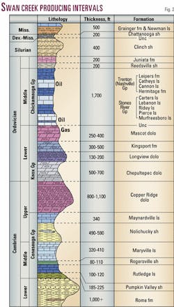
The best oil well, the 5 Paul Reed, contains 29 ft of pay in the Stones River Group (Fig. 2). It tested at 360 b/d, initially produced more than 100 b/d after completion in August 1999, and is currently making 56 b/d, yielding a cumulative 48,088 bbl through June 2001. From the tank battery the oil is trucked to the nearest refinery at Somerset, Ky.
Current limit to production from this and other oil wells is the reservoir capacity and to a lesser degree the capacity of the pumps being employed. Capacity of the pumps being employed is more than 100 b/d, so most wells including the 5 Paul Reed are being pumped at capacity.
Oil from Swan Creek field is 52° gravity, typical for oil in the Appalachian region. It is commonly amber colored and contains a small amount of paraffin.
Gas from the field contains 1,000-1,100 Btu/Mcf and contains no sulfur, no CO2 , and little nitrogen. Gas is thus marketed directly from the wellhead with only minor processing consisting of scrubbing to remove any water and condensate.
Rose Hill field in Lee County, Va., 15 miles northwest of Swan Creek field, has been producing since 1942.3 Rose Hill field is on the crest of the Powell Valley anticline (Fig. 1), several fault blocks northwest of Swan Creek field and structurally much closer to the northwestern edge of the overthrust belt.
Production there involves oil from the Middle Ordovician Stones River and Trenton Groups, similar to Swan Creek, although Rose Hill is mostly an oil field.
Daily production from Rose Hill field, however, was initially greater than that at Swan Creek but now is considerably less than that of Swan Creek.4 Despite similarities in producing stratigraphic interval and involvement in the overthrust belt, other direct comparisons are difficult.
Swan Creek geology
Swan Creek field geology is very complex.
Complexity is related not only to the structural setting of the field in the internal parts of the Appalachian foreland fold-thrust belt but also to the nature of the structure where hydrocarbons are located.
The field is located beneath the Clinchport thrust sheet in a duplex that formed as the footwall was broken by the northwestward-advancing thrust sheet. As the thrust sheet continued to move, the footwall was increasingly deformed and the duplex arched the hanging wall above it.
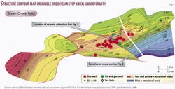
Hydrocarbons are trapped in the upper Knox Group (Cambrian to Lower Ordovician) and in the overlying Middle Ordovician Stones River and Trenton Groups (Fig. 2). Upper Ordovician and Lower Silurian, Upper Devonian, and lower Mississippian rocks occur higher in the section.
The Knox here consists mostly of dolomite with some limestone, whereas the Middle Ordovician rocks are mostly limestone. The top-of-Knox Middle Ordovician unconformity separates the Knox from the Middle Ordovician rocks. Almost all of the oil has been found in the Middle Ordovician rocks, while most of the gas occurs in the Knox.
Porosity in the host rocks is both primary and secondary, with the primary porosity in the Knox playing an important role in reservoirs with a range of 4-18%. Secondary porosity in the form of fractures in all rock units is also critical in reservoir development.
Gas chromatographic analyses of oil samples from Swan Creek field by the US Geological Survey reveal that the oil was derived from an algal source, probably in the Ordovician carbonate section. This is an extremely important conclusion because it was assumed before that all of the hydrocarbons in the Appalachian basin had the Devonian shale as the source.
The possibility of Ordovician oil and gas opens up a very large area and many structures as plays that before were assumed to be barren because of the lack of Devonian shale in the section. If there are viable structures, the major variables determining whether economic hydrocarbons will be present become the porosity and thermal maturity of the Knox and overlying Middle Ordovician rocks.
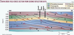
The producing structure at Swan Creek is a faulted footwall anticlinal complex-probably a duplex-developed beneath a hanging wall flap in the Clinchport thrust sheet (Fig. 3). The Clinchport thrust sheet places Lower Cambrian Rome formation rocks onto a syncline containing rocks as young as Mississippian. The southeastern limb of this footwall syncline is faulted and arched into a subsurface anticline.
Hydrocarbon exploration has concentrated on the anticlinal portion of the footwall. This setting is one not commonly explored in thrust belts: hanging-wall anticlines above thrusts are traditionally more commonly explored and therefore more productive.
Industry seismic reflection data collected in the late 1970s and early 1980s by Amoco and ARCO have been used to reconstruct the structure beneath the thrust sheet (Fig. 4).
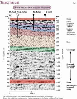
New 2D seismic lines have been shot in critical parts of the field, adding important detail to the structural interpretation (Fig. 5). Strong marker reflections occur at the top of the Conasauga Group and in the Rome formation, allowing the structure to be mapped with confidence.
Tengasco's exploration strategy combines 2D seismic profiling, both on roads and cross country, with drilling. This strategy is effective in part because the structure has a strong 2D grain parallel to the Appalachians and in part because drilling costs are relatively low.
Feasibility studies revealed that a 3D seismic program would be more expensive and problematic because it would have to be carried out cross country in rugged terrain.
The structure revealed in the reconstructions consists of a series of anticlines that ride on small-displacement imbricate thrusts that formed along with the footwall syncline beneath the main Clinchport thrust sheet (Fig. 3). These small faults produce deformation zones of different thicknesses along them that are a key to secondary porosity enhancement contributing to hydrocarbon accumulation in Swan Creek field.
The entire subthrust structure comprises a duplex with the Clinchport thrust serving as the roof and the Wallen Valley thrust serving as the floor. The small imbricate faults and faulted anticlines form the "horses" in the duplex.
Ga.-Va.-Tenn.?
Swan Creek field on the one hand is unique in its size and productivity in the Appalachian thrust belt, with boundaries still poorly defined.
On the other hand, the structural style and stratigraphic assemblage at Swan Creek are present at a number of places throughout the southern Appalachian foreland fold-thrust belt.
So, other fields like Swan Creek may exist in eastern Tennessee, albeit probably not as large. Even cursory examination of the state geologic map of Tennessee5 reveals numerous structures-like and unlike Swan Creek-that could be productive.
Closer examination of these potential plays, however, quickly diminishes the number from 100 or more to a more realistic 20 to 30 possibilities. Considering the thrust belt in northwestern Georgia and southwestern Virginia increases the number of reasonable plays by another 15 to 20. The number of plays will probably decrease again as drilling permits determination of the porosity and provides better control on reservoir architecture.
A major consideration in the location of additional plays is the thermal maturation of the rocks in this region, discussed by Clendening and McCown.1 Thermal maturation of the rocks of the Appalachian foreland fold-thrust belt in Tennessee and southwestern Virginia measured by the conodont alteration index (CAI),6 7 vitrinite reflectance, and other techniques, increases southeastward toward the crystalline core of the Appalachian orogen.
Swan Creek field is located west of the oil-gas window (CAI 2.5 to 3; Fig. 1) in an ideal setting for occurrence of both oil and gas. Structures similar to Swan Creek occur both in the oil-gas window and in the gas window.
Other structures that are not Swan Creek analogs are also potentially productive.
The recent success of locating plays in the Knox equivalents and the Trenton-Black River sequences in Newfoundland8 and in New York, coupled with the Swan Creek success, may be indicative of greater potential in other parts of the Appalachians in the same interval.
Tengasco has begun exploration and leasing of several new plays. It is acquiring new seismic reflection data and expects to be drilling several exploratory wells in the next 18 months.
References
- Clendening, J.A., and McCown, M.W., "Swan Creek field: Potential giant develops in Tennessee," OGJ, Apr. 19, 1999, pp. 95-99.
- Ryder-Scott, December 2000.
- Miller, R.L., and Fuller, J.O., "Geology and oil resources of the Rose Hill District-the fenster area of the Cumberland overthrust block-Lee County, Virginia," Virginia Geological Survey, Bull. 71, 1954, 383 p.
- Bartlett, Charles S. Jr., "Trenton limestone fracture reservoirs in Lee County, Southwest Virginia," OGJ, June 10, 1985, p. 164.
- Hardeman, W.D., "Geologic map of Tennessee," Tennessee Division of Geology, scale 1:250,000, 1966.
- Epstein, A.G., Epstein, J.B., and Harris, L.D., "Conodont color alteration-an index to organic metamorphism," US Geological Survey Professional Paper 995, 1977, 27 p.
- Orndorf, R.C., Harris, A.G., and Schultz, A.P., "Reevaluation of conodont color alteration patterns in Ordovician rocks, east-central Valley and Ridge and western Blue Ridge Provinces, Tennessee," US Geological Survey Bull. 1839, 1988, 10 p.
- Cooper, M., and nine others, "Basin evolution in western Newfoundland: New insights from hydrocarbon exploration," AAPG Bull., Vol. 85, 2001, pp. 393-418.
The authors
Dr. Robert D. Hatcher Jr. is a distinguished scientist and professor at the University of Tennessee in Knoxville. He is a structural/tectonics geologist who has worked for more than 35 years in the Appalachians after spending a year in New Orleans with Humble Oil & Refining Co., now ExxonMobil. His research is supported by the National Science Foundation, Department of the Interior, and private industry. Additional support has recently been provided by the US Department of Energy's National Petroleum Technology Office. He is a director of Tengasco Inc. E-mail: [email protected]
Dr. Richard T. Williams is an associate professor of geological sciences at the University of Tennessee in Knoxville. He is a seismologist who has over 20 years' experience in acquisition of seismic and gravity data in the Appalachians and other regions. He is responsible for designing the seismic data acquisition and processing program for Tengasco.
Michael W. McCown is chief geologist with Tengasco. Also an engineer, he has 30 years of industry experience. He has worked with Schlumberger Well Services and several independent operators. He also has expertise in satellite imagery, geomorphology, structural geology and tectonics, and geophysics. He holds a BS degree in geology from the University of Toledo.
