Trujillo basin off Peru contains numerous promising structures
The Trujillo basin project was initiated by Perupetro and completed by the PARSEP Group to investigate the remaining undiscovered hydrocarbon potential in the Trujillo basin, located offshore northwestern Peru. PARSEP, or "Proyecto de Asistencia para La Reglamentación del Sector Energético del Perú," is a joint venture between the governments of Peru and Canada.
Gary Wine, Teknica, Calgary
Elmer Martinez G., Carlos Monges R., Ysabel Calderón C. & Carlos Galdos S., Perupetro SA, Lima
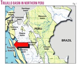
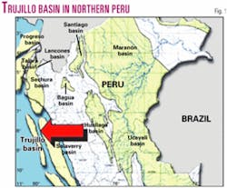
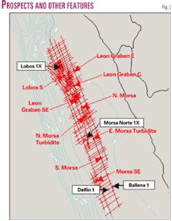
The Trujillo basin along the coast of Peru is a wrench-type basin developed as a series of "en echelon" narrow transtensional gashes attributed to left-lateral displacement along a subduction-parallel, NNW-trending slip fault during the Tertiary (Fig. 1).
The Trujillo area is divided into two geological provinces represented by two distinctively different basement types.
Of economic significance are the upper to lower bathyal turbidite fan complexes of the Middle Miocene to Cretaceous aged sequences. To date these reservoirs have been intersected only in the Lower Eocene (Delfin and Lobos wells) and Campanian (Lobos well).
The best oil source rocks identified to date in the basin are within the Middle and Lower Miocene and Upper Eocene sequences which are Types II to II/III.
The Trujillo basin contains a wide variety of and numerous structural features. Basin inversion features, four-way dip, and fault dependent closures over high basement horst blocks, tilted fault blocks, dip reversals in growth faults, etc., are in abundance and in varying sizes. The focus of this study was on large features that had closures of 50 sq km or more and consequently could contain sufficient reserves to withstand a rigorous economic evaluation.
Five pure structural plays in this evaluation were mapped with sizes ranging from 50 to 350 sq km. The largest structure at 350 sq km is the South Morsa feature. Should reservoirs be encountered over this basement high block, giant size reserves could be discovered.
One of the more attractive structural plays is the Leon Graben East prospect, which is a "trap door styled" structural inversion that also has four-way dip closure. The objective reservoir rocks are of Middle Miocene age.
The real significant upside in the Trujillo basin may ultimately lie with combination stratigraphic/structural plays. These are typically represented as amplitude anomalies (single or multiple events) and/or mounding within the basinal depressions that are seen to thin and eventually onlap basement as the basin flank is approached to the east.
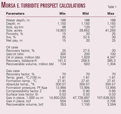
Four such prospects are noted. The main stratigraphic prospect is the Morsa East "turbidite," which is an amplitude feature that when mapped takes on the geometry of a significant fan deposit (Table 1). The other three stratigraphic styled prospects/leads, although geologically and geophysically interesting, require further work.
Regional geology
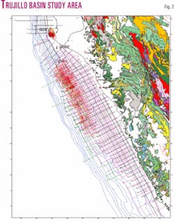
Peru's coastal strike-slip basins are characteristically narrow and relatively deep and are connected via basement horsts or extensional faults, depending on whether the strike-slip faults are left stepping or right stepping (Fig. 2).
The Trujillo area is divided into two geological provinces represented by two distinctively different basement types. The suture between these two provinces is believed to be a 20-km zone of northwest trending strike-slip faults in the offshore to the south and onshore through the Bayovar Peninsula to the north.
A Mesozoic Andean-type suite of magmatic rocks forms the basement of the Salaverry, Trujillo, and probably Sechura South onshore basins; the suite consists of slightly metamorphosed, volcaniclastic assemblages and intrusive batholiths.
In contrast, the northwestern basins (North Trujillo, offshore Sechura South, Sechura North, Lancones, Talara, and Tumbes) were formed in a Paleozoic basement consisting of highly metamorphosed igneous intrusives with heterogeneous lithologies that have no obvious Andean affinities.
The evolution of the Trujillo basin can be described as a series of compressive and extensional events generated by wrench tectonics.
Four compressive events and two extensional episodes have been postulated for the Trujillo area. The four compressive events are Paleocene, late Eocene to Oligocene, upper-middle to late Miocene, and middle Pliocene. The two extensional episodes that took place are middle Eocene and late Pliocene.
Stratigraphy, reservoirs
Eight main sedimentary sequences have been recognized in the geological evolution of the Trujillo basin.
The first episode corresponds to the pre-Eocene (Campanian to Paleocene section, Lobos 1X well).
The second to seventh sequences correspond to Lower-Middle Eocene, Upper Eocene, Oligocene, Lower Miocene, Middle Miocene, Upper Miocene, and Plio-Quaternary.
Of economic significance are the upper to lower bathyal turbidite fan complexes of the Middle Miocene to Cretaceous aged sequences. To date these reservoirs have been intersected only in the Middle Eocene (Delfin well), Lower Eocene (Lobos well), and Campanian (Lobos well) sequences. For comparison purposes, the Lower Eocene clastic section of the Talara basin is the most oil prolific and thickest section of northwestern Peru.
Additionally, in the Trujillo, reservoirs have been inferred within the Middle Miocene, Upper Eocene section by seismic high amplitude events and geometries. An unknown is the Cretaceous section below Campanian in the northern half of Trujillo basin, which has yet to be tested.
Reservoirs were encountered in two of the four wells drilled in the area, Lobos (poor to fair) and Delfin (good). Both Morsa and Ballena were not necessarily drilled in an ideal location (highs) to encounter sediments of a turbidite depositional environment. Seismic supports the possible existence of large turbidite sand bodies/packages throughout the Trujillo basin area.
Geochemistry
Fore-arc basins are generally considered to be thermodynamically cold and consequently barren of economic deposits of hydrocarbons due to a lack of source rock maturation.
The Trujillo basin on the other hand has proven itself to be a generative and productive basin in this respect. The oil seeps that abound throughout the Trujillo basin area, the significant oil shows encountered in the Morsa Norte 1X well, and the gas shows in the Delfin 1X well, attest to this fact.
The best oil source rocks identified to date in the basin are within the Middle and Lower Miocene and Upper Eocene sequences which are types II to II/III. The Lower Eocene has been identified as a fair type III gas prone source rock. Conversely, the principal source rock identified in the Talara basin is the Albian Muerto shale.
Although the Muerto shale has yet to be penetrated in the Trujillo basin, thick sequences of Cretaceous rocks have been identified seismically in the north half the basin with just the uppermost portion of this being tagged by the Lobos 1X well. It is thus through inferences that the Muerto shale as in Talara is expected to be the principal source rock in the Trujillo basin. Oil to source rock correlations, however, have not been conclusive in confirming this fact.
To date some of the studies have suggested that the Tertiary was perhaps the source for a number of analyzed oils. Others suggest an Upper and Lower Cretaceous source. Basin modeling studies have shown that only the Cretaceous rocks can reach a level of maturity capable of hydrocarbon generation with our current understanding of the geological evolution of the Trujillo basin.
Until our tectonic model of the area changes in light of some new data or interpretation, it must therefore be assumed the Cretaceous is in fact the source of the Trujillo basin hydrocarbons.
Trujillo prospects
Basin inversion features, four-way dip, and fault dependent closures over high basement horst blocks, tilted fault blocks, dip reversals in growth faults, etc., are in abundance and in varying sizes in the Trujillo basin.
All the prospects presented here have closures, or in the case of the stratigraphic-type plays an areal extent, of 50 sq km or more and consequently could contain sufficient reserves to withstand a rigorous economic evaluation.
Of the nine prospects presented in this display, only one is in more than 500 m of water, three are in 200-300 m of water, and the rest are less than 200 m of water.
The two prospects deemed to be the most attractive, the East Morsa "turbidite" and the Leon Graben East, are in 170 and 100 m of water, respectively.
The other three stratigraphic styled prospects/leads, although geologically and geophysically interesting, require further work (Fig. 3).
East Morsa 'turbidite'
This feature is located within a small graben separating the Salaverry regional high to the east and the Morsa structure to the west (drilled by Repsol in 1999).
The prospect is defined by a high amplitude seismic event that is interpreted to be an axial submarine fan flowing from north to south along strike of the graben.
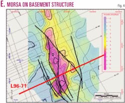
The high amplitude event may possibly be indicative of a gas charged sand. In support of this, the amplitude feature all along its western boundary is seen to terminate abruptly against postdepositional faults and as such does not appear to be controlled by stratigraphic changes. This to some degree is also evidenced to the east, although this boundary appears to be more stratigraphic in nature due to a gradual loss of amplitude (Fig. 4).
The significant oil shows encountered throughout the Morsa Norte 1X well located just to the west of the prospect suggest that there has been significant hydrocarbon generation in the Morsa graben and migration throughout the area.
The amplitude feature tested by the Morsa 1X well was concluded to have been caused by a channelized, conglomeratic debris flow of limited areal extent.
The East Morsa amplitude feature apart from this stands out because of its size, greater than 160 sq km, fan-like geometry, and setting within a depositional low. This anomaly can be clearly identified on at least eight seismic lines (Fig. 5). Combined, these indicate the presence of a major turbiditic sand body and not that of a localized debris flow as encountered in the Morsa 1X well.
N. Morsa structure
The North Morsa structure is an intensely faulted, accommodation-styled structural high of some 55 sq km closure that separates the Leon graben to the north from the Morsa graben to the south.
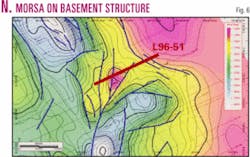
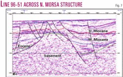
Vertical closure is 500 ms two-way time at basement. The structure is ideally located between the Leon and Morsa grabens, which both contain over 4 sec of sedimentary section and are considered to be two of the probable source areas for the hydrocarbons generated in the Trujillo basin (Figs. 6 and 7).
As this has remained a high through geological time, it represents a major focal point for the migration of hydrocarbons but runs the added risk of poor reservoir development.
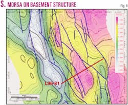
S. Morsa structure
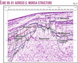
This prospect is a large, robust basement structural high with almost 350 sq km of closure at the 1,540 ms contour interval.
It is located approximately 20 km southwest of the Morsa North 1X well, which encountered significant shows of oils believed to have been sourced from the Morsa graben to the west.
Due to the prospect's proximal location to same source area, the Morsa South structure should easily have access to sufficient hydrocarbon charge. Reservoir development is the largest risk associated with this prospect (Figs. 8 and 9).
N. Morsa 'turbidite' prospect
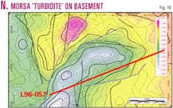
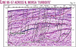
The North Morsa "turbidite" prospect is located in the northernmost 'arm' of the Morsa graben and is characterized as an Upper Eocene sedimentary mound with seismically chaotic internal composition.
The entire package, from top Upper Eocene to base package, pinches out eastwards. This would imply that east of this pinchout some or most of the Upper Eocene would be missing. The western part of this package is anomalous by the fact that the high chaotic appearance ends abruptly against down-to-the-basin faults.
This seismically chaotic section is most probably due to an alternating high and low energy environment that shed an abundant mixture of sediments, probably shales, sands, and conglomerates, into the basin, with the provenance being mostly from the northeast direction (Figs. 10 and 11).
The package that envelops the chaotic seismic character has a well-defined top.
However, the base is erratic, discontinuous, and difficult to accurately identify. Of interest is also that when the same envelope grades into a transparent section, devoid of high amplitude seismic reflectors, the base of the envelope is displayed as a high amplitude positive reflector.
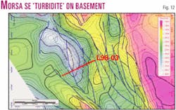
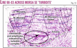
Morsa SE 'turbidite'
The Morsa SE "turbidite" is represented seismically by an Eocene wedge of sediments that thins from the deepest part of the Morsa graben to the east onto the basin's flank.
Within this section, sediment mounding is evident with sporadic high amplitude events that generally dissipate from east to west, which is also the presumed direction of sediment flow.
This wedge/mounded feature is interpreted to be turbidite fan complex that extends from the basin flank into the basinal syncline of the Morsa graben (Figs. 12 and 13).
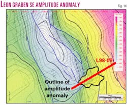
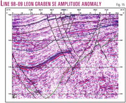
Amplitude feature
The Leon graben Southwest amplitude feature is a lead that is similar in many ways to Morsa East except that the anomalous feature is within the Middle Eocene.
Since the environment of deposition would have been middle to lower bathyal, it is reasonable to define it as a turbiditic sand flowing axially from north to south within an environment of middle to high energy (Figs. 14 and 15).
Lobos South prospect
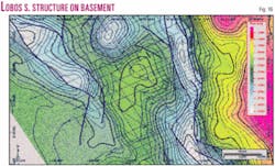
This is a large structural feature defined by closure mapped on basement and is of some 225 sq km in size that separates the Leon (Lobos) Cretaceous subbasin to the north from the principal depression of the Leon graben to the east (Fig. 16).
From the interpretation done for this study it was concluded that the Miocene/Oligocene section has been eroded off the crest of this structure and that the sedimentary section to be encountered will consist of an Eocene to Cretaceous succession similar to the one intersected in the Lobos 1X well.
Leon Graben E. prospect
This prospect is located on the Salaverry high just east of the Leon graben, 25 km east of the Lobos 1X well.
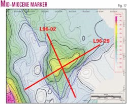
Some 100 sq km of closure has been mapped at the Mid-Miocene level (Fig. 17), which can be projected at depth to a significant unconformity that has been interpreted as being the top of Cretaceous (or possibly top Paleocene).
At the interpreted basement reflector, there is no apparent closure as this was once a deposition low that had been inverted through several transpressional pulses. This inversion to some degree can be seen along the entire length of the Salaverry high. The Leon Graben East structure is one of two prospects mapped in this project with this tectonic style.
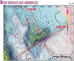
The map displayed in Fig. 18 is an identically contoured map to the one shown in Fig. 17 but overlain with near surface gas anomalies.
The authors
Gary Wine ([email protected]) is senior petroleum geologist and leader of the PARSEP Project. He has worked as a consultant for American and international projects. From 1978 to 1996 he was an exploration geologist for Norcen Energy Resources in the US, Canada, Southeast Asia, and South America. He graduated from British Columbia University.
Elmer Martinez Gonzales (emartinez@peru- petro.com) is senior geologist with 23 years of experience in seismic interpretation and acquisition. Since 1999 he has worked for Perupetro SA as a senior geophysicist and PARSEP coordinator, working in Peruvian hydrocarbon basin evaluations. He is a graduate of the geology school, Universidad de San Marcos.
Carlos A. Monges ([email protected]) is senior petroleum geologist for Perupetro with 25 years of international experience in the oil industry, mostly in Peru and Latin America. He is exploration manager of BPZ Energy Perú and was part of the PARSEP project team in 1999-2001. He participated in the geological and geophysical assessment of the Trujillo and Salaverry forearc basins and the Huallaga and Marañon foreland basins. He holds a BS in geologic engineering from San Marcos University.
Ysabel Calderon ([email protected]) has worked for Perupetro since November 1999 as a geologist assistance (PARSEP Project). She worked for Geosurvey SA in geodesic and environmental studies and in Occidental in 1997-98 as a junior geologist. She graduated with a geology degree from San Marcos University.
Carlos Galdos ([email protected]) has worked for Perupetro since November 1999 as geophysicist assistant (PARSEP Project). In 1999 he worked for Occidental Peruana Inc. Sucursal Del Peru as a junior geophysicist. (OXY data room, digitized well, and offshore Block Z3). He is a graduate of San Agustin University.
