South East Asia contains abundant, untapped unconventional reservoirs
Ahmed ElSakka
Ghareb M. Hamada
Eswaran Padmanabhan
Ahmed M. Salim
University Teknologi Petronas
Seri Iskandar, Malaysia
Shale development is poised to renew interest in exploring for oil and gas in Southeast Asia. Basins in Malaysia, China, India, Pakistan, Indonesia, and Thailand hold prospective formations, but more study is necessary to unlock these reserves.
China's prospective 1,115 tcf of shale gas is by far the largest prospect in the region, followed by India (584 tcf). Malaysia represents the region's lowest potential with an estimated 8.8 tcf of recoverable shale gas resources.
This article outlines shale gas resources in Southeast Asia that could transform local energy markets, especially those relying on crude oil imports, as economies in the region continue to grow.
Malaysia
Malaysia is the world's third-largest exporter of liquefied natural gas (LNG), and the second largest oil and natural gas producer in Southeast Asia.
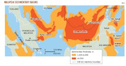
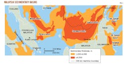
Malaysian sedimentary basins are heavily faulted with a variety of natural traps, which is encouraging for oil and gas development. Six tertiary-age basins are present in the country, including the Malay, Penyu, Sarawak, Sabah, Sandakan, and a portion of the Tarakin basin (Fig. 1).1 To date, shale gas discoveries have been made in only the Sarawak and Sabah basins, both of which as part of large accumulations. The basins are grouped into three larger regions, including a Peninsular basin, Sarawak, and Sabah. Sabah and Sarawak comprise 200,000 sq km, or about 60% of the land mass, in East Malaysia. The oldest Sarawak formation dates to 300 million years. These ancient rocks form part of the West Borneo basement that makes up the exposed part of Sundaland in southwest Borneo, making it related to continental Southeast Asia. The basement is built up of Paleozoic and Mesozoic rocks. Most of Sarawak is underlain by younger Tertiary sedimentary rocks, especially northeast of the Lupar River.
Based on preliminary resource assessment, Malaysia has an estimated 8.8 tcf of shale gas resources.
Sarawak basin
The prospective Setap shale formation is composed of inner neritic clay-shale and silty clay, occasionally interbedded with sandstone, calcareous sandstone, and moderately thick limestone. Setap has poor-fair organic content in hard and semihard to unconsolidated sandstone, heterolithic coal seams, paleosol, and thick mudstone (likely shelf and marginal marine) with total organic carbon (TOC) of 7-8%.
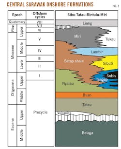
Sedimentary cycles subdivide the stratigraphy of the Sarawak Tertiary sequence and have been identified in eight separate geological regions, namely the West Baram Delta, Balingian, Central Luconia, Tinjar, Tatau, West and southwest Luconia, and southwest Sarawak Provinces (Fig. 2). The sedimentary succession on the Sarawak basin shelf is more than 12-km thick and also contains the Sibuti formation that is comprised of shale, interbedded siltstone, and limestone.
Sabah basin
The Sabah basin has three sections, with the northwest section mostly offshore. The other two sections-northeast and southeast-are onshore Sabah. The entire basin contains 12-km thick Neogene sediments that were deposited within the deep marine and progradation shelf slope environment.2
Peninsular basin
Malaysia's Peninsular region has four main basins, the Malay basin and the Penyu basin are offshore to the east of the peninsula. The Central and North Sumatra basins lie to the west of the peninsula and are mostly offshore with small portions lying onshore. The Malay basin contains Neogene sediments about 12-km thick that were deposited within the non-marine to shallow marine environment. In the Penyu basin, oil has been discovered on horst blocks of the Oligocene synrift play consisting of fluvial sandstone reservoirs.
China shale prospects
Behind US and Canada, China is the third largest in developing its shale gas resources.
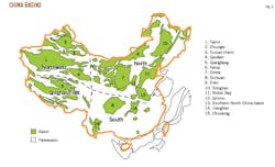
In southern China the Sichuan, Jianghan, and Chuxiong basins are the most prolific. Ordos, Bohai Bay, and Songliao basins are prospective in northern China. The Tarim and Qaidam basins in northwest China and the Qiangtang-Tibet basin in the south are also target areas for shale gas (Fig. 3).
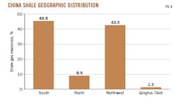
Most of China's shale gas (46.8%) is in the southern region, primarily in the Sichuan basin. The north-northwest Tarim and Ordos basins contain 43% of China's estimated shale resources. The remaining basins account for 10.2% of total shale gas (Fig. 4).
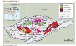
Prospective formations include both marine and continental shales and transitional facies. Technically recoverable gas in China's Tarim (216 tcf) and Sichuan (626 tcf) basins are mainly in marine and lacustrine-deposited shales (Fig. 5). The US Energy Information Agency (EIA) estimates that the Sichuan and Tarim basins contain technically recoverable reserves of 1,275 tcf if 25% of the shale gas can be produced.
Sichuan and Tarim basins make up two of China's largest organic shale plays and include five minor basins: Songliao, Bohai, Ordos, Tuha, and Jungar (Fig. 5). Sichuan is the most promising short-term development opportunity given the basin's existing pipeline infrastructure and the region's mature gas market.
Sichuan basin
Sichuan basin shale exploration has focused on marine-deposited, dry-gas mature source rock shales that resemble other commercially productive shales. The Sichuan basin covers 190,000 sq km in south-central China. The basin currently produces about 1.5 bcfd of natural gas from conventional and low-permeability sandstones and carbonates within the Triassic Xujiahe and Feixianguan formations that feature complex structural-stratigraphic traps (mainly faulted anticlines) distributed across the basin.
Sichuan basin is in the Changning-Weiyuan area, where productive formations are in a high degree of thermal evolution with vitrinite reflectance (Ro) ranging 2.0-4.0%, porosity 3.0-4.8%, gas concentration 2.82-3.28 cu m/tonne, and moderate burial depth of 1,500-4,500 m (Table 1). EIA's Shale Report assessment estimates Sichuan shale formations are at an average depth of 11,000 ft, and technically recoverable resources are an estimated 18 trillion cu m.3
Despite its multiple shale targets, the Sichuan basin has a number of geologic challenges. Numerous faults, often steep dips, and high tectonic stress make optimization difficult. Drilling conditions may also be hindered by hard formations and high levels of H2S and CO2 in specific areas.
The Sichuan basin has four tectonic zones: the northwest depression, central uplift, and the East and South fold belts. The central uplift, characterized by relatively simple structure and comparatively few faults, is the most attractive region for shale gas development. In contrast, the East and South fold belts are structurally more complex, with numerous closely spaced folds and faults.
The four organic-rich shale targets in the Sichuan basin are the Lower Cambrian Qiongzhusi, Lower Silurian Longmaxi, Lower Permian Qixia, and the Upper Permian Longtan formations (Table 2). The Lower Silurian Longmaxi formation is possibly the most prospective of these as it contains an average 300 m of organically rich, black, graptolitic-bearing, siliceous to cherty shale. TOC is mostly low-moderate, reaching 4% and consisting mainly of Type II kerogen. Thermal maturity is high and increases with depth, ranging from dry gas prone to over mature (Ro=2.4-3.6%).
The Cambrian Qiongzhusi formation, even though deeper than the Longmaxi and mostly separated out by the 5-km depth, contains high-quality source rocks that provide stacked shale resource potential. The formation was deposited under shallow marine continental shelf conditions and has an overall thickness of 250-600 m.
Tarim basin
The 600,000 sq km Tarim basin, in the Xinjiang Autonomous Region, is China's largest onshore sedimentary basin. It produces 260,000 b/d of oil and 1.6 bcfd of natural gas from conventional reservoirs that are sourced from organic-rich Cambrian and Ordovician shales (Fig. 5).
Tarim basin is subdivided by fault and fold systems into a series of seven distinct structural zones, comprising three uplifts and four depressions. Petroleum source rocks are found in the Cambrian, Ordovician, Carboniferous Triassic, Cretaceous, and Tertiary. Marine deposited black shales of Cambrian and Ordovician age are the most important source rocks in the basin.4 Tarim's and other northern China marine deposits often have high organic content with Ro=1.1-2.5%. Organic matter is mostly Type II-III kerogen, and these deposits are at average depths of 13,500 ft.
India shale gas
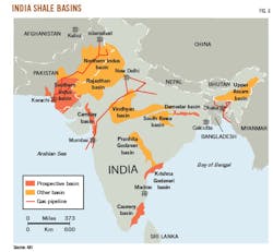
India has prospective shale formations in four major sedimentary basins, including the Cambay, Krishna-Godavari (KG), Cauvery, and Damodar Valley (Fig. 6). Each of these are marked by thick shales, TOC of 2-6 wt %, and Ro > 1 (Table 3).5
Other prospective basins include Vinghyan, Upper Assam, Pranhita-Godovari, and Rajasthan. These basins show thermal immaturity, but do contain measurable thicknesses and suitable TOC. Despite the country's vast shale gas resources, strict government policies and a lack of technology and technical expertise have left most of these resources untapped.
KG basin
Located on India's East Coast, KG basin covers a 15,000 sq km area onshore and another 25,000 sq km offshore. KG basin's shales are limited within four grabens or sub-basins where thermal maturity is sufficiently high for wet-dry gas generation.6 Estimated risked shale gas in place is 136 tcf with a risked technically recoverable resource of 27 tcf (Table 3).
Cauvery basin
The Cauvery basin covers 25,000 sq km onshore and 30,000 sq km in shallow offshore areas. The basin contains a thick interval of organic rich source rocks in Lower Cretaceous Andimadam and Sattapadi shale formations. The oldest rocks in the Cauvery basin are the shallow marine, late Jurassic sediments, and early Cretaceous deposits. Average resource is estimated at 43 tcf of risked shale gas in-place, of which 9 tcf is considered technically recoverable (Table 3).
Damodar Valley basin
The Damodar Valley basin is part of a group of basins collectively named Gondwana.7 The Gondwana encompasses the Satpura, Pranhita-Godavari, Son-Mahanadi, and Damodar basins. The Damodar is estimated to contain 33 tcf of risked shale gas in-place, of which 7 tcf is considered technically recoverable (Table 3).
Southern Indus basin
The Southern Indus basin, which is primarily in southern Pakistan, is accessible on India's northern border. To date, there have been five commercial oil discoveries and one gas discovery in conventional Cretaceous-age reservoirs. There are an additional three gas discoveries and one gas condensate discovery in shallower formations.
Pakistan
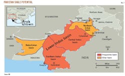
Pakistan's shale gas and oil resources rank ninth largest in the world, exceeding the total resources available in the rest of Central Asia (Fig. 7). The Upper, Lower Indus basin, Balochistan, and Pasheen are three of the country's primary sedimentary basins, totaling 827,365 sq km.
Indus basin
The Precambrian Indus basin consists of an Upper region that includes two sub-basins: Kohat and Potwar. The Lower Indus basin includes the central and southern portion. The Indus basin covers a combined 271,700 sq km, which is about 33% of the country's sedimentary area.8
Indus basin is enriched by thick-sequence shale formations that have sourced proven petroleum systems. EIA estimates Pakistan's shale gas resources to be 586 tcf, however, technically recoverable shale gas is closer to 100-105 tcf (Fig. 8).6 Indus basin shale formations are known to source Pakistan's conventional discoveries, but there has been no shale-specific exploration publicly reported for the country.
Lower Indus basin
The Sembar and Ranikot formations make up the Lower Indus basin's shale prospects. The Sembar formation has 531 tcf of risked shale gas in place, of which 101 tcf is technically recoverable. The Ranikot shale has estimated risked shale gas and oil in place of 55 tcf and 82 billion bbl, respectively.
The Sembar formation consists of clastic rocks, typically shale with lesser quantities of siltstone and sandstone. The sand content increases toward the southeast, but the formation is composed of siltstone with marls and shales in the central basin. Sembar shales are medium hard, pyritic, moderately indurated, and slightly calcareous with a gross thickness of >50-800 m. Sembar's TOC and Ro are consistent with exploration targets at around 2% and 1.0-1.6%, respectively.
The Paleocene Ranikot formation is an upper carbonate unit tailored with fossiliferous limestone interbedded with dolomitic shale, calcareous sandstone, and abundant bituminous material. The formation's prospective layer is 1,000-3,000 ft thick with a net-shale thickness of 200 ft. Ranikot contains an estimated 4 tcf of wet gas.
Thailand
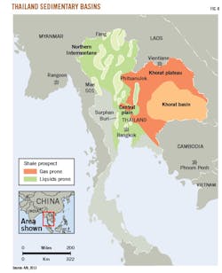
Nearly 90% of Thailand's petroleum output comes from offshore fields in the Gulf of Thailand, with only limited production from small onshore fields. Natural gas supplies 40% of Thailand's energy consumption. The country's most prospective shale gas deposits are Permian and Triassic sources in Thailand's largest onshore sedimentary basin, the Khorat. These shales can be locally thick, organic-rich, dry-gas prone, deeply buried, and overpressured.
In addition to Khorat basin in the northeast, Thailand has a series of smaller, isolated pull-apart basins in the northern Intermontane basin with ongoing mining of shale oil (Fig. 8). The country also has potential in the central Plains basin. Khorat basin has an estimated 5 tcf of risked technically recoverable shale gas, but no exploration activity has been reported.
Khorat basin
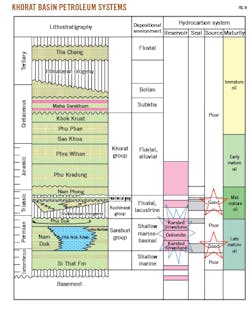
Thailand's 35,000 sq km Khorat basin is a structural depression initiated during Middle Paleozoic with widespread deposition of clastic and carbonate sedimentary rocks, beginning with the Carboniferous Si That formation.1
Kuchinarai Group averages depths 6,500-7,000 ft. Thermal maturity modeling suggests it reaches the dry gas window with no liquids potential (Ro > 2.0%). The shallow marine to basinal Permian Saraburi Group is considered the basin's primary source, while the high-TOC fluvial to lacustrine Triassic Kuchinari and Huai Hin Lat Groups offer additional source potential (Fig. 9). Permian dolomite and karsted limestones form the main conventional petroleum reservoirs.
Indonesia shale gas
Indonesia has marine-deposited shale gas and oil potential, as well as more extensive shale resources within non-marine and often coaly shale deposits. Technically recoverable reserves are estimated to be 46 tcf out of 303 tcf of risked shale gas in place.9
Indonesian onshore basins' petroleum source rocks are young, mostly Eocene to Pliocene.10
Onshore sedimentary basins with shale gas potential include Central and South Sumatra basins and Kutei and Tarakan basins in Kalimantan. In eastern Indonesia, the Salawati, Bintuni, and Tomori basins have shale potential, but these are structurally complex. Most of Indonesia's remaining basins are less prospective with low TOC, high clay content, and excessive levels of CO2.
Many of Indonesia's organic-rich shales are nonmarine coaly deposits that may not be brittle enough for development. Depositional settings range from deepwater marine in eastern Indonesia to mostly lacustrine and deltaic environments in central and western Indonesia.
Bintuni basin
Bintuni basin, in the eastern side of the Bird's Head region, has the simplest structural conditions and best shale prospectivity in eastern Indonesia. The stratigraphic section resembles that of the Salawati basin, with preserved Paleozoic, Mesozoic, and Tertiary units. The prospective areas of the Permian Aifam formation have an estimated 29 tcf of technically recoverable shale gas resources out of 114 tcf of gas in place.1 The marine-deposited Aifam formation could be the best shale gas target in Indonesia. To date no shale leasing or exploration activity has been reported in eastern Indonesia.
Sumatra basin
Sumatra has shale oil and gas potential in three deep basin complexes: The North, Central, and South Sumatra basins. The North Sumatra basin produces mainly conventional gas both on- and offshore. Central Sumatra basin is one of the more prospective for shale gas, with technically recoverable resources from the Brown formation estimated at 3.3 tcf.
South Sumatra basin produces conventional oil and gas, but it has potential shale gas and coalbed methane exploration potential. The basin contains late Eocene to early Oligocene deposits of clastic sediments in transgressional pull-apart depressions. The Eocene to Oligocene Talang Akar formation is prospective within a large 15,490-sq-mile area and estimated to have a 367-ft thick high-graded zone with an average 5% TOC and 0.7% Ro. The pressure gradient is normal with a high clay content. The Talang Akar formation has an estimated 4.1 tcf of technically recoverable shale gas.
References
1. EIA, "Technically Recoverable Shale Oil and Shale Gas Resources: An Assessment of 137 Shale Formations in 41 Countries Outside the United States," June 2013, www.eia.gov.
2. Wang, X., "The Evolving Unconventional Gas in China," Society of Petroleum Engineers (SPE) Annual Technical Conference and Exhibition (ATCE), San Antonio, Tex., Oct. 8-10, 2012.
3. Zonggang, L.V., Wang, L., Shea, J., Wang, Q., and Dumesnill, J., "Search for Unconventional Gas in Asia Pacific Region: Chinese Cambrian Age Marine Qiongzhusi Shale Gas Play: Case History, Operation, and Execution," SPE ATCE, San Antonio, Tex., Oct. 8-10, 2012.
4. Cai, C.F., Li, K.K., Ma, A.L., Zhang, C.M., Xu, Z.M., Worden, R.H., Wu, G.H., Zhang, B.S., and Chen, L.X, "Distinguishing Cambrian from Lower Ordovician Source Rocks: Evidence from Sulfur Isotopes and Biomarkers in the Tarim Basin," Organic Chemistry, Vol. 40, No. 7, April 2009, pp. 755-768.
5. Sain, K., Rai, M., and Sen, M., "A review on shale gas prospects in Indian sedimentary basins," Journal of India's Geophysical Union, Vol. 18, No. 2, April 2014, pp. 183-194.
6. Mahto, V., "Shale Gas in India: Status and Challenges," Journal of Petroleum Engineering and Technology, Vol. 4, No. 1, January 2014, pp. 23-32.
7. Rahmalia, D., "Shale gas potential in Indonesia-'More' to the East," Indonesian Petroleum Association, 36th Annual Convention and Exhibition, Jakarta, May 23-25, 2012.
8. Haider, B., Aizad, T., Ayaz, S., and Shoukry, A., "A Comprehensive Shale Gas Exploitation Sequence for Pakistan and Other Emerging Shale Plays," SPE No. 163123, SPE/Pakistan Association of Petroleum Geoscientists (PAPG) Annual Technical Conference, Islamabad, Pakistan, Dec. 3-5, 2012.
9. Abidin, Z.A., "At an Investment Crossroads: Malaysia Versus Indonesia," No. SPE-176285, SPE/Society of Indonesian Petroleum Engineers (IATMI) Asia Pacific Oil and Gas Conference and Exhibition, Nusa Dua, Bali, Indonesia, Oct. 20-22, 2015.
10. Rogner, H.H. and Weijermars, R., "The Uncertainty of Future Commercial Shale Gas Availability," SPE No. 167710, SPE/European Association of Geoscientists and Engineers (EAGE) European Unconventional Resources Conference and Exhibition, Vienna, Austria, Feb. 25-27, 2014.
The authors
Ahmed-ElSakka ([email protected]) earned an MS in petroleum engineering (2017) from Universiti Teknologi Petronas, Perak, Malaysia. He has previously worked for Tri-Ocean Energy as a reservoir engineer. He holds a BS in petroleum engineering from the British University in Egypt, Cairo. He is a member of the Society of Petroleum Engineers (SPE).
Gharib M. Hamada ([email protected]) is an associate professor of petroleum engineering at the Universiti Teknologi Petronas. He also served as faculty at the Future University, Cairo, Egypt, and has taught at a number of other universities. Hamada holds a BS and MS in petroleum engineering from Cairo University, Egypt. He also holds a PhD in applied geophysics from Bordeaux University, France. He is a member of SPE and the Society of Petrophysicists and Well Log Analysts (SPWLA).
Eswaran Padmanabhan ([email protected]) is director of the Institute of Hydrocarbon Recovery at Universiti Teknologi Petronas and an associate professor in the Department of Geoscience. He earned his BS (1988) in geology from the University of Malaysia, Kuala Lumpur. He also holds an MS (1991) from Rijksuniversiteit Ghent, Belgium. He earned his PhD (1995) from the University of Saskatchewan, Saskatoon, Canada.
Ahmed M. Salim ([email protected] ) is a senior lecturer in the department of geoscience with the Universiti Teknologi Petronas. He previously worked as faculty at Red Sea University, Sudan. He holds a BS in geology from the University of Khartoum, Sudan. He earned an MS and PhD in geophysics from Central South University, Changsha, China.
