Western Siberia’s arctic area given 3.66 billion bbl, 651 tcf undiscovered
There are an estimated 3.66 billion bbl of undiscovered oil and 651 tcf of natural gas north of the Arctic Circle in Russia’s West Siberian Basin Province, the US Geological Survey said in a recent report.
The entire Western Siberian Basin Province is the world’s largest petroleum basin with an areal extent of nearly 2.2 million sq km and a total discovered volume of more than 360 billion boe, the US Department of the Interior agency said in the report it prepared as part of its Circum-Arctic Resource Appraisal program.
Exploration has led to the discovery of several giant oil and gas fields, including Urengoi gas field, with more than 3,500 tcf of estimated ultimate recovery, and Samotlor oil field, with EUR of more than 28 billion bbl of oil, the report said. Urengoi field lies at 66° 40’ N. Lat., and Samotlor is at 61° 10’.
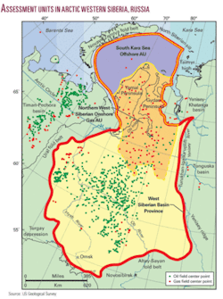
The USGS evaluated two assessment units in the province’s northern part above the Arctic Circle: the Northern West Siberian Onshore Gas AU, which includes primarily Cretaceous sandstone reservoirs in structural traps, and the South Kara Sea Offshore AU, which is considered to be an offshore geologic extension with similar traps and reservoirs.
All of the South Kara Sea AU and about 75% of the Northern West Siberian Onshore AU lie above the Arctic Circle (see map).
The report said there are an estimated 3.659 billion bbl of undiscovered oil (1.152 billion bbl onshore and 2.507 billion bbl offshore), 651,499 bcf of natural gas (29,277 bcf onshore and 622,222 bcf offshore) and 20.329 billion bbl of natural gas liquids (850 million bbl onshore and 19,479 million bbl offshore) in the evaluated area.
The higher offshore gas estimate reflects the fact that the area has not been explored as extensively as the onshore area, USGS said.
The province
The sprawling West Siberian Basin Province is a large rift-sag feature.
It is bounded to the west by the Ural fold belt, to the north by the Novaya Zemlya fold belt and North Siberian sill, to the south by the Turgay depression and Altay-Sayan fold belt, and to the east by the Yenisey ridge, Turukhan-Igarka uplift, Yenisey-Khatanga basin, and Taimyr high.
The USGS previously assessed the entire province in 2000. For the most recent assessment it adopted the total petroleum system and AUs it defined in 2000, but it only assessed those parts of the AUs that lie wholly or partly north of the Arctic Circle.

