Sri Lanka’s Mannar basin holds untapped gas potential
Thomas L. Davis
Geologist, Ventura, Calif.
Amila Sandaruwan Ratnayake
Uva Wellassa University, Sri Lanka
Offshore Sri Lanka contains undeveloped oil and gas resources. Mannar basin straddles Sri Lankan and Indian waters and has only been explored by a handful of wells. Previous attempts at developing two natural gas fields in upper Cretaceous clastic beds in the northern part of the basin were halted due to low commodity prices.
Recent increases in spot prices and demand for gas in the region, however, have spawned renewed interest in the basin. This article addresses such interest by estimating development cost and recoverable reserves for the basin using analog field data and a United States Geological Survey (USGS) of the regional geology. Newer 2D and 3D seismic and interpretation, combined with an enhanced 2D vintage grid, will also aid exploration along the eastern basin margin.
Sri Lanka offshore opportunity
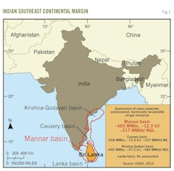
The southeast continental margin area of the Indian subcontinent, including offshore Sri Lanka, contains considerable discovered and undiscovered oil and gas resources (Fig. 1). This area includes offshore Mannar basin which straddles Sri Lankan and Indian waters. Two large deepwater gas fields were discovered in the area but remain undeveloped. Geologic studies indicate this area has significant petroleum potential with several prospective plays, but it lacks a single test well to prove out the potential.
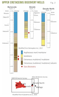
The Sri Lankan portion of Mannar basin’s proven petroleum resources remains undeveloped and underexplored, with only five exploration wells drilled in the northern part of the basin. Three additional discovery wells Dorado North, Wallago, and Pearl-1 were non-commercial (Fig. 2).
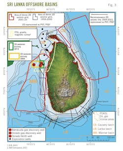
In 2011 Cairn Lanka Pvt. Ltd. drilled Barracuda and Dorado wells and discovered two natural gas fields in upper Cretaceous clastic beds (Fig. 3). Cairn departed the undeveloped fields in 2015, declaring them not commercial at the then prevailing spot oil price of $40/bbl and Asian LNG spot price of $7.00/MMbtu.
This article considers the current estimated value and development costs of the fields compared with similar deepwater gas fields based on a 2012 USGS assessment which summarized the Sri Lankan portion of the basin’s geology, its petroleum systems, and the exploration database. The study estimated the potential and value of undiscovered hydrocarbon resources in this portion of the basin.
Future exploration in Mannar basin will benefit from this data resource, which consists of a dense grid of newer 2D-seismic data, 3D-seismic survey coverage over (and adjacent to) the natural gas discoveries, and a vintage 2D grid with reconnaissance lines along the eastern basin margin.
Mannar basin
Sri Lanka has a total of 14,174 sq km of 2D seismic covering much of its waters within Mannar, Cauvery, and Lanka basins identifying larger traps and basin geometries. Cauvery basin lies just north of Mannar basin and some investigators consider the two basins one. A combination of 2D lines and a 2009 3D survey led to the discovery of the Dorada and Barracuda gas fields, followed by a 2012 3D survey. Fig. 2 shows areas of reprocessed 2D seismic data into pre-stack time and pre-stack depth imaging. Additional data include airborne 3D full-tensor gradiometry, gravity, and magnetic data with interpretation over the northern portion of Mannar and Cauvery basins.
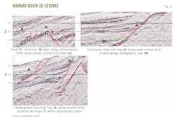
Seismic mapping and tectonic history support basin crustal extension and rotational opening during the breakup of Gondwanaland in the late Jurassic-early Cretaceous. 2D-seismic images show a rift basin with horsts and grabens that became submarine ridges and basins with subsidence and marine incursion. The setting formed numerous extensional-structural traps and favored deposition of sand-rich, growth-strata deposits filling accommodation spaces and stratigraphic traps (Fig. 4).
Restricted circulation in sub-basins provided the anaerobic, oxygen-poor conditions for source rock deposition and preservation. Possible right-lateral strike-slip occurred during the basin opening, either with rotation forming additional structural traps or rotation forming the traps alone. Basin modeling indicates continued basin subsidence and deepening from Cretaceous through Eocene.
Deepening marine conditions and increasing distance from shore caused the earlier formed traps to be blanketed with thick shale-rich sealing beds. Continual basin subsidence was conducive to deepwater turbidite-fan deposition in the central basin and formation of large stratigraphic traps with interbedded claystone-capping seals. Subsidence of the basin center continued through the Neogene, forming a thick overburden and burying source rocks to oil and gas maturation depths while providing and preserving traps and reservoirs. 2D-seismic images identified convergent-style traps from convergence along preexisting normal and transform faults.
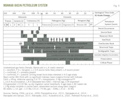
A petroleum-system event diagram was constructed for Mannar basin from cited studies that includes proven and probable source rock, reservoir, and sealing units (Fig. 5). Organic-rich and thermally mature source rock are the most essential elements of any productive petroleum system. Analyses of Barracuda, Dorado, and Dorado North well samples confirm that the upper Cretaceous shale is a good-to-fair source rock (average total organic carbon (TOC) is 1.37% in Barracuda, 1.39% in Dorado, and 1.64% in Dorado North). A rich, early Cretaceous source rock is likely present in the central part of Mannar basin given its earlier history and recognition of a synchronous major global anoxic event in adjacent Cauvery basin. There are no well penetrations below the upper Cretaceous in Mannar basin, however, to explore this possible source.
Less certain is the presence of an upper Jurassic source rock equivalent to those in the small, coastal-onshore Andigama basin of northwest Sri Lanka (3.05-5.10% TOC). Maturity modeling studies indicate that the generative potential of the three source rock units across the basin are constrained more by their level of thermal maturity than organic content. For instance, upper Cretaceous shale is mature for oil generation in the Barracuda and Dorado wells but immature for oil-gas and gas-prone source rocks, while detailed analysis of the Dorado North well showed that it is a good source rock for gas generation if thermal maturity is reached.
Basin modeling shows about 110-million years ago (Ma) late Jurassic oil and gas source-rock initiated generation, about 75-Ma early Cretaceous oil, about 30-Ma gas-source generation, and about 35-Ma late Cretaceous oil-source generation. Seismic imaging indicates that the basin margins are more structurally and stratigraphically complex with large basin-edge faults. The margins show rotated blocks with relative uplift which could create erosion and form unconformity traps in abbreviated sections. Mannar basin margins have more potential for traps but are smaller and more difficult to image.
Barracuda, Dorado fields
Barracuda and Dorado, the basin’s undeveloped natural gas fields, prove out a productive petroleum system and suggest that the basin’s geology contains additional systems. The stratigraphic and structural traps in the late Jurassic through Eocene section in the central part of the basin, have excellent conditions for hydrocarbon accumulations. These conditions include source-rock generation postdating most of the trap formation, short migration pathways from source to trap, larger and less-faulted traps with thick reservoir and sealing beds, and a thick overburden section for trap preservation.
Central-basin Late Jurassic and Cretaceous traps contain less risk and are more favored for hydrocarbon accumulations. About 50% of Mannar basin, however, is in water depths greater than 3,000 m and therefore prohibitively difficult and expensive to drill. About 40% of the basin is in 200-3,000 m of water, within technical offshore drilling limits but still expensive to develop. About 10% of the basin is within its narrow eastern shelf, where water depths are less than 200 m. Prospects in the shallow water would be less expensive to explore and develop, but they are also smaller and geologically riskier due to structural complexity, more abbreviated sections of reservoir and seal, and longer migration pathways from mature source(s) to traps.
Mannar basin recoverable hydrocarbons
In 2012 USGS published a geologically-based assessment of undiscovered, technically recoverable, conventional petroleum resources which included Mannar and Cauvery basins. Lanka basin was not assessed due to lack of geologic data. The USGS assessment is a petroleum system-based analysis and part of a project to estimate technically recoverable petroleum resources for priority basins worldwide.
Table 1 shows the estimated USGS mean volumes for crude oil, NGL, and natural gas in Mannar basin. The current study’s estimate of the basin’s ultimate resource value is based on crude oil and NGL at $70/bbl and natural gas at $11.20/MMbtu, which represents conservative spot market average prices for several years.
About 66% of Mannar basin lies within Sri Lankan waters based on USGS basin boundaries and the maritime boundary with India. In these waters, the basin’s recoverable fossil fuel resources are valued at $6.54 billion, assuming 5% of the resources are discovered and economically producible. The estimate may be conservative if the petroleum system contains suspected but unproven source rocks and traps.
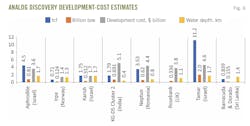
Development costs for Barracuda and Dorado come from analog deepwater gas and gas-liquid field discoveries of comparable size and water depth (Fig. 6). Norway’s Irpa field’s hydrocarbon volumes and water depth are most comparable to the combined Barracuda and Dorado resource and suggest resource development costs of about $1.4 billion. A general benefit-to-cost ratio of 6 suggests that the fields are commercially viable at the referenced spot market prices.
References
- Heafford, A., “Limited tender for offshore block M2 – Partnership with SRI LANKA government for underexplored Mannar Basin,” S&P Global Commodity Insights, Blog, June 23, 2017.
- Baker, G. and Sims, L., “Rosebank field, the UK’s largest undeveloped oil and gas field receives development approval from the NSTA,” S&P Global Commodity Insights, Sept. 28, 2023.
- Bell Geospace, Sri Lanka Multiclient Programme, 2021.
- Caines, J., “Deepwater Roundup: Europe and Middle East,” Hart Energy, Apr. 25, 2023.
- Dave, H.D., Mazumder, S., Samal, J.K., Pangtey, K.K.S., and D.S., Mitra, “Mapping Hydrocarbon seepages using satellite SAR data in Eastern Offshore (India) - Essential Input in Oil Exploration, 9th Biennial International Conference & Exposition on Petroleum Geophyiscs, Hyderabad, India, Feb. 16–18, 2012.
- Desa, M. A., Ramana, M. V., and Ramprasad, T., “Seafloor spreading magnetic anomalies south off Sri Lanka,” Marine Geology, Vol. 229, No. 3–4, July 2013, pp. 227–240.
- DeSilva, N., “Compressional Tectonics and Oil Fields Offshore Sri Lanka,” AAPG International Conference and exhibition, Perth, Nov. 5–8, 2006.
- Fava, L., Tremblay, F., and Cutten, S., “Stratigraphic evolution and sediment dispersal in a marine rift-basin: The case of the Lewis trough, Eastern Dampier sub-basin (Australia),” 106666, Marine and Petroleum Geology, Vol. 161, March 2024.
- Henderson, S, “Israel’s Karish Offshore Gas Field: Facts and Figures,” The Washington Institute for Near East Policy, June 14, 2022.
- Klett, T.R., Schenk, C.J., Wandrey, C.J., Charpentier, R.R., Cook, T.A., Brownfield, M.E., Pitman, J.K., and Pollastro, R.M, “Assessment of undiscovered oil and gas resources of the Assam, Bombay, Cauvery, and Krishna–Godavari Provinces, South Asia,” US Geological Survey Fact Sheet 2012–3059, 2011.
- Kularathna, E.K.C.W., Pitawala, H.M.T.G.A., Senaratne, A., and Ratnayake, A.S., “Play distribution and the hydrocarbon potential of the Mannar Basin, Sri Lanka,” Journal of Petroleum Exploration and Production Technology, Vol. 10, May 12, 2020, pp. 2225–2243.
- Kurukulasuria, L., “The Geopolitics of Sri Lanka’s Energy Crisis,” The Diplomat, Feb. 16, 2023.
- Lal, N. K., Siawal, A., and Anil Kaul, K., “Evolution of east coast of India—A plate tectonic reconstruction,” Journal Geological Society of India,Vol. 73, No. 2, February 2009, pp. 249–260.
- Magoon and Beaumont, “Petroleum Systems,” AAPG Search and Discovery article #40068, 2003.
- NS Energy, “North Karish,” Mar. 2, 2021.
- NS Energy, “Tamar Field,” Jan. 6, 2023.
- Ocean: insights from the deepwater Mannar Basin, Sri Lanka,” Article 37, Geo-Marine Letters, Vol. 41, July 21, 2021.
- Offshore Technology, “Irpa Gas Field, Norwegian Sea, Norway,” Projects, Feb. 14, 2023.
- Offshore Technology, “Neptun Deep Gas Field Project, Black Sea.” Projects, July 7, 2023.
- Offshore Technology, “Oil & gas field profile: Irpa Conventional Gas Field, Norway,” Premium Insights, updated May 27, 2024.
- OMV Petrom, “Neptun Deep,” www.omvpetrom.com, 2024.
- Paraskova, T., “India’s ONGC Ready To Start Oil Production At $5-Billion Deepwater Project,” Oil Price.com, Nov. 13, 2023.
- Petroleum Development Authority of Sri Lanka, Ministry of Power and Energy, “Explore Sri Lanka,” 2023.
- Petroleum Resources Development Secretariat, “Petroleum Exploration and Development in Sri Lanka,” Apr. 10, 2019.
- Premarathne, D.M.U.A., Suzuki, N., Ratnayake, N.P., and Kularathne, E.K.C.W., “A Petroleum System in the Gulf of Mannar Basin, Offshore Sri Lanka,” Proceedings to 29th Technical Sessions of Geological Society of Sri Lanka, published online, Feb. 22, 2013.
- Ratheesh‐Kumar, R.T., Dharmapriya, P. L., Windley, B. F., Xiao, W. J., and Jeevan, U., “The Tectonic “Umbilical Cord” Linking India and Sri Lanka and the Tale of their Failed Rift,” Journal of Geophysical Research Solid Earth, Vol. 125, No. 5, Apr. 14, 2020.
- Ratnayake, A. and Sampei, Y., “Characterization of organic matter and depositional environment of the Jurassic small sedimentary basins exposed in the northwest onshore area of Sri Lanka, Researches in Organic Geochemistry, Vol. 31, No. 1, 2015, pp. 15–28.
- Ratnayake, A., “Late Cretaceous to Miocene Paleoclimatic changes in the Indian Ocean: Insights from the Deepwater Mannar basin, Sri Lanka," Geo-Marine Letters, Vol. 41, No. 37, 2021.
- Ratnayake, A., “Paleoenvironments and source rock potential of Dorado North well in the Mannar Basin (Indian Ocean),” Article 792, Arabian Journal of Geosciences, Vol. 14, Apr. 21, 2021.
- Ratnayake, A., Kularathne, C.W., and Sampei, Y., “Assessment of hydrocarbon generation potential and thermal maturity of the offshore Mannar Basin, Sri Lanka,” Journal of Petroleum Exploration and Production Technology, Vol. 8, 2018, pp: 641-654.
- Ratnayake, A., Sampei, Y., and Kularathne, C.W., “Current status of hydrocarbon exploration in Sri Lanka,” International Journal of Oil, Gas and Coal Technology, Vol. 16, No. 4, January 2017.
- Ratnayake, A., Sampei, Y., and Kularathne, C.W., “Stratigraphic responses to major depositional events from the late Cretaceous to Miocene in the Mannar Basin, Sri Lanka,” Journal of Geological Society of Sri Lanka, Vol. 16. January 2014, pp. 5-18.
- Sastri, V.V., Venkatachala, B.S., and Narayanan V., “The evolution of the east coast of India,” Palaeogeography, Palaeoclimatology, Palaeoecology, Vol. 36, No. 1-2, November 1981, pp. 23-54.
- Schenk, O., Tu, C., Ngo, L., Ong, W.C., and Kularathna, C., “Unlocking the hydrocarbon potential of the Mannar Basin (Sri Lanka) based on new data and new ideas,” First Break, Vol. 40, No. 7, July 2022, pp. 75-84.
- SLB, “Schlumberger Sri Lanka Multiclient Programme,” Offshore Sri Lanka Surveys, 2023.
- USGS, “Geological Survey National Oil and Gas Resource Assessment Team,” 1995.
- World Bank, “Sri Lanka Development Update 2023,” Oct. 3, 2023.
- Wrobel, S., “Israel’s NewMed Energy and partners begin drilling at Aphrodite gas field off Cyprus,” The Times of Israel, May 31, 2023.
- Yanqun, Q., Guangya, Z., Zhifeng, J., Zhi L., Yiping, W., Xinglong, W., and Xu, L., “Geological features, hydrocarbon accumulation and deep-water potential of East Indian basins,” Petroleum Exploration and Development, Vol. 44, No. 5, pp. 731–744.
- The authors
- Thomas L. Davis ([email protected]) is Owner-Principal at Thomas L Davis Geologist in Ventura, Calif. He holds a PhD (1976) from the University of Santa Barbara, Calif.
- Amila Sandaruwan Ratnayake ([email protected]) is a professor at Uva Wellassa University, He holds a PhD (2015) from Shimane University, Japan. He is the 2024-2025 President of the Geological Society of Sri Lanka (GSSL).
