Studies assess Central Nigeria’s Bida basin potential
Olumuyiwa A. Olawoki
Geospectra Nigeria Ltd.
Lekki, Lagos
Sam J. Coker
Skangix Development Ltd.
Lekki, Lagos
Morufu A. Rahaman
Obafemi Awolowo University
Ile-Ife, Nigeria
Suyi L. Fadiya
Obafemi Awolowo University
Ile-Ife, Nigeria
Rafiu B. Bale
University of Ilorin
Ilorin, Nigeria
Recent structural and stratigraphic information show Bida basin, the least studied of Nigeria’s inland frontier basins, as likely having appreciable oil and gas resources. No exploration wells have been drilled.
This article examines geophysical data and lithofacies of exposed outcrops in the southern and central basin. Additional study needs to be done, including field trips, 2D seismic acquisition, and integration of surface and critical subsurface well data.
Obafemi Awolowo University recently produced a revised geological basin map that reflects a central structural low trend where argillaceous and prolific source rock facies can accumulate.
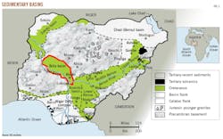
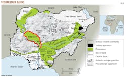
Fig. 1 shows Nigeria’s sedimentary basins. Bida basin is underlain by an asymmetrical, graben rift system with major northwest-southeast faults. Bida and Kwali structural highs separate the Batamegi, Gadza, and Okoto subbasins.
Sediments believed to be pre-Santonian are exposed in Filele road cut outcrops northwest of Lokoja. The sediments are 1-5 m thick, yellowish-greenish, medium-coarse grained sandstone with folded purple lenticular clay deposits.
Biostratigraphic analyses shows no Campano-Maastrichtian palynomorph or foraminifera, possibly due to harsh Late Cretaceous tectonics. Oil and gas potential likely exists in the Early Cretaceous lacustrine terrestrial and marine source beds 4,000-6,000 m deep.
Field work during 2017 documented fanglomerates, slope channel, and fan reservoir deposits. Stratigraphic traps exist, leading researchers to infer structural stratigraphic traps in the pre-Santonian stratigraphic interval after tectonic compression.
Recorded Kerogen transformation odors detected while drilling through deep shale along with shallow magnetic mineral deposits, as exhibited in the Agbaja Ironstone Plateau, suggest gas microseeps via vertical migration from deeper source rock.
Two speculative petroleum systems are proposed: deep Turonian and shallow Campanian. Similar proved analog rift basins in Uganda and India support Bida basin’s oil and gas potential.
Structural framework
Bida basin’s structural evolution is unclear. Researchers previously proposed three theories:
• Simple Sag model related to the evolution of post-Santonian Anambra basin.1
• Strike Slip model related to Basement megashear tectonics in Gboko-Kotangora regional transform fault system.2-3
• Rift model related to Benue trough tectonics and gravity-aeromagnetics studies.4
Geologic maps show a series of regional basement-related lineaments within and around Bida basin along the Kaduna, Oshin, and Dinyo rivers. The lineaments are related to the deeper regional rift faults masked by the shallower sediments and linked to Benue trough.5
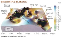
Nigeria Geological Survey Agency (NGSA) in 2012 published a 3D model of Bida basin’s basement topography, using aeromagnetic data and spectral analysis. This model shows a series of well-defined, aligned crustal highs and lows and some magnetic spikes.
Authors reviewed the basement topography using micromagnetic analysis to enhance the definition of regional northwest-southeast faults, throw directions, and to highlight the rift tectonic setting.6 Subsurface fault trends run the same direction as fractures.
The northern regional fault bounding Bida basin with a northwest-southeast trend is interpreted as the Gboko-Kotangora fault and believed to be part of the Aptian-Albian Benue trough.7
Gravity and magnetic studies show the basement complex can be 3,200 m deep in the central basin.8 NGSA’s 2012 model from aeromagnetic spectral analysis is interpreted to show horsts and grabens at 3,500 m, which likely developed during the Aptian-Albian rift phase.
Bida basin is underlain by an asymmetrical, full graben rift setting. Consequently, three depocenters were renamed Batamegi, Gadza, and Okoto subbasins after nearby villages.
Fig. 2 shows Kwali High, a faulted east-west trending basement high. It merges with Bida High and connects to the northwest-southeast Dalcada Ridge. Kwali High divides Bida basin into northern and southern compartments. Researchers postulated the Lokoja High separates Bida basin from Anambra basin (OGJ, Apr. 6, 2015, p. 52).
More than 80% of oil and gas discoveries are associated with hydrocarbon-induced magnetic anomalies.9 Magnetotactic bacteria are known to feed on the gas to generate some magnetic minerals near the surface, which could be the case in Bida basin. Widespread tropical weathering effects and mineral alterations can hide hydrocarbon-related magnetic minerals. The magnetic spikes noted in the NGSA (2012) map might suggest gas microseeps.
Stratigraphic framework
A shallow outcrop suggests underlying older pre-Santonian sediments will include fanglomerates deposited under turbid gravity flow at the basin’s flank, alternating sands and claystone-shale along with slope channel and fan sands in the central basin.
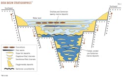
Fig. 3 shows slope fans, thick shales, or claystone deposits in the distal setting. Lokoja and Ahoko (Patti) formations have been studied for reservoir and source rock properties.
Lokoja formation is mainly turbiditic conglomeratic sands with some quartzite fragments, cemented feldspathic sandstone relicts and claystone interbeds. Ahoko (Patti) formation is dark grey carbonaceous shales with high source rock potential, lignite seams, as well as siltstone and mudstone deposits.
Bida basin has structural highs and regional lows, accommodating sediment piles of more than 4,000 m thick and believed to contain Aptian-Albian sediments along the basin’s deeper central graben section.
With the regional Gboko-Kotangora fault tied to the Benue trough rift system, researchers believe the Cenomanian-Coniacian marine transgression into Southern Benue trough extends into the adjacent Bida basin rift setting.
All three depocenters are expected to contain pre-Santonian sediments made up of proximal fanglomerates, central slope channel sands, and distal slope fan deposits within thick shale sections.
Oyi river presently carries Maastrichtian sediment into the basin. It flows primarily into the Emimagi depocenter in the western-southwestern part of Batamegi subbasin.
At Filele, researchers noted 1-5 m of greenish medium-to-coarse, moderately sorted, indurated, folded sandstone levels with purple shale patches and sedimentary sequence. Researchers believe the interval below the regional Santonian unconformity is Pre-Santonian, probably Turonian-Coniacian.
Observers report a similar greenish sandstone section in the Open University valley area that is texturally comparable to the Koton Karfi-Ozi village scarp outcrop section. Detailed biostratigraphic analyses found no palynomorphs and foraminifera species.
Petroleum systems
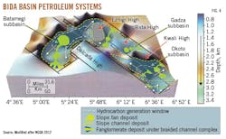
Bida basin’s petroleum systems can only be speculated on for now. Fig. 4 shows two proposed petroleum systems:
• Deep Turonian slope fan lacustrine shale.
• Shallow Campanian fanglomerate marine shale.
Previous research indicates hydrocarbon generation and expulsion characteristics and potential of the Turonian Lokpanta shales from Southern Benue trough.8
A prolific source facies is suggested to extend into deeper parts of Bida basin. Authors assume the Aptian-Cenomanian section may be too deep or sandy to contribute appreciable hydrocarbons.
Some researchers suggest sediments cover both overburden rock and source beds although the amount of sediment has yet to be estimated for the pre-Santonian interval. Ahoko-area coal seams indicate at least 1,500 m of sediment exists.
Bida basin has hosted 4,000-6,000 m of sediments since the Early Cretaceous. High geothermal and geopressure likely transformed kerogens into oil and gas accumulations.
A thick overburden drives source materials through the hydrocarbon generative window.
Tight impermeable claystone and shale are expected to provide both vertical and lateral seals across reservoir levels by lithologic juxtaposition. In cases of vertical movement along the fault plane, shale can provide adequate lateral sealing. Rapid lateral facies changes are well documented.
The slope channel, fan complexes, and turbiditic fanglomerate deposits are thin-to-thick, stacked, and laterally extensive. Rivers carried sediment into the basin flanks, which moved downdip to form individual fanglomerate reservoir deposits.
Erosion and changing water levels contributed to the development of a braided channel on top of the fanglomerate deposits. The eroded sediments moved downdip into the slope channel and fan deposits within potential source rock.
Many authors have worked on the kerogen type, maturity level, and generative potential of the basin’s outcrop shale levels. Bida basin source rocks are believed to be gas prone with minor oil potential.
Deep lacustrine and marine shales have hydrocarbon generation potential and will charge the embedded slope channel and fan reservoir facies.
References
1. Adeniyi, J., “The Geology of the Mid-Niger Basin,” Geology of Nigeria, 2nd Ed., 1989, pp. 283-287.
2. Braide, S., “Syntectonic Fluvial Sedimentation in the Central Bida Basin,” Journal of Mining and Geology, Vol. 28, No. 1, January 1992, pp. 55-64.
3. Whiteman A., “Nigeria: Its Petroleum Geology, Resources and Potential,” Graham and Trotman, Vol. 1-2, 1982, p. 394.
4. Ojo, O., and Akande, S., “Facies Relationships and Depositional Environments of the Upper Cretaceous Lokoja Formation in the Bida Basin, Nigeria,” Journal of Mining and Geology, Vol. 39, No. 1, January 2003, pp. 39-48.
5. Benkhelil, J., “The Origin and Evolution of the Cretaceous Benue Trough (Nigeria),” Journal of African Earth Sciences (and the Middle East), Vol. 8, No. 2-4, 1989, pp. 251-282.
6. Tedesco, S., “Utilizing Aeromagnetics and Micromagnetics to Define Petroleum Reservoirs in the Denver, Forest City, and Cherokee basins,” American Association of Petroleum Geologists/Society of Exploration Geophyscists, International Conference & Exhibition, Barcelona, Spain, Apr. 3-6, 2016.
7. Ojoh, K., “The Southern Part of the Benue Trough (Nigeria) Cretaceous Stratigraphy, Basin Analysis, Paleo-Oceanography and Geodynamic Evolution in the Equatorial Domain of the South Atlantic,” Nigerian Association of Petroleum Explorationists Bulletin, Vol. 7, No. 2, November 1992, pp. 131-152.
8. Ekweozor, C., and Unomah, G., “First discovery of oil shale in the Benue Trough, Nigeria,” Fuel, Vol. 69, No. 4, April 1990, pp. 502-508.
9. Schumacher, D., “Non-seismic Detection of Hydrocarbons,” American Association of Petroleum Geologists Latin America and Caribbean Region, 20th Caribbean Geological Conference 2015, Port-of-Spain, Trinidad & Tobago, May 17-22, 2015.
The authors
Olumuyiwa A. Olawoki ([email protected]) is managing consultant for Geospectra Nigeria Ltd., Lagos. His 26 years’ industry experience includes jobs with Agip-ENI, Shell, Mobil, and ExxonMobil. His consultant work covers geoscience projects and acreage acquisition opportunities across West Africa and East Africa. His interests are technical knowledge sharing, solid mineral resources evaluation, seismic stratigraphy, petroleum system analyses and defining hydrocarbon resources. He holds a PhD (2014) from Obafemi Awolowo University, Ile-lfe, Osun State.
Sam J. Coker ([email protected]) is managing director of Skangix Development Ltd. He has more than 40 years professional experience including teaching and consulting on jobs. He holds a BS in geology and MS in petroleum geology-sedimentology.
Morufu A. Rahaman ([email protected]) is a professor at Obafemi Awolowo University. An expert on Precambrian geology of Africa, his main interest is helping geoscientists receive training. For 9 years, he coordinated the aptitude examination used by the Petroleum Technology Development Fund to select MS scholarship beneficiaries for selected universities in Britain. |
Suyi L. Fadiya ([email protected]) has a PhD (2008) degree in applied geology from Obafemi Awolowo University and a diploma certificate (2010) in advanced academic practice from Newcastle University, UK. He worked as a micropaleontologist and biostratigrapher with many companies, including Crystal Age Ltd. Fadiya lectures at Obafemi Awolowo University. He is editor-in-chief of the Nigerian Association of Petroleum Explorationists Bulletin.
Rafiu B. Bale ([email protected]) possesses a BS (1975) in geology from Ibadan University, Nigeria; MS (1980) in industrial mineralogy from the University of Hull, UK, and a PhD (1984) in geology from the University of Southampton, UK. He was an intern with Chevron Nigeria Ltd., geologist with National Steel Raw Materials Research and Development Council, and Nigeria Geological Survey Agency. He joined the University of Ilorin as a graduate assistant in 1976 and became a professor in 2014. He is a chartered geologist registered with the Council for Mining Engineers and Geologists. |
