Japan explores for hydrates in the Nankai Trough
OFFSHORE JAPAN-1
Hideaki Takahashi
Japan Petroleum Exploration Co. Ltd.
Tokyo
Yoshihiro Tsuji
Japan Oil, Gas and Metals National Corp.
Chiba City
In early 2004, the Japanese completed field operations for a second methane hydrate exploration program in the Nankai Trough.
Japan’s Ministry of Economy, Trade, and Industry (METI, restructured in 2001 from MITI, Ministry of International Trade and Industry) led the project to evaluate geologic prospects off central Japan, part of an ongoing research program to evaluate natural methane hydrates as a potential energy source. The operations in January-May 2004 were based on the technologies developed during the first exploration campaign in 1999-2000.1
The 2004 program was organized by the Japan National Oil Corp. (JNOC, restructured to JOGMEC, Japan Oil, Gas, and Metals National Corp., in 2004) in collaboration with Japan Petroleum Exploration Co. Ltd. (JAPEX) as the drilling operator and with Teikoku Oil Co. Ltd. (TOC).
In total, 32 wells were drilled through the BSR (bottom-simulating reflector) horizon at the water depth of 720 m to 2,033 m over a 122-day period. Sixteen wells were logged while drilling (LWD). Two wells had high accuracy borehole temperature (BHT) sensors installed. Two wells were wireline-logged, 12 wells were cored, and 2 wells (including 1 horizontal well) were cased and used experimentally to verify technologies for the future. All scheduled programs were performed successfully with the deepwater research vessel JOIDES Resolution, operated by Transocean Inc.
This article introduces the general program, including logging while drilling, wireline logging, and coring activities. The concluding part next week will provide details of the experimental drilling program, the borehole temperature-sensing program, and a discussion of the drilling and operational issues encountered while drilling for natural hydrates in the Nankai Trough.
Background
Japan has been interested in natural gas hydrate as a potential future energy source and has developed systematic research programs in the last decade. In 1995, MITI established the initial program and declared it would drill an exploration well offshore Japan within 5 years. JNOC immediately organized the research teams, leading 10 private Japanese companies, including JAPEX, to develop the most efficient methodology for the challenging exploration drilling program.2
Based on research results, the world’s first offshore natural hydrate exploration wells were successfully drilled from November 1999 to February 2000 at a single location in the Nankai Trough off Japan. The water depth was 945 m and bottom-simulating reflectors (BSR) were clear on the seismic section.1 The program had extremely valuable results regarding how hydrate occurred at the wells.3-5 One of the biggest accomplishments of the first program was to establish the methodology to evaluate hydrate occurrence by drilling.
In order to explore the extensive area effectively during the 2004 program, researchers planned to drill many wells at many locations. 2D and 3D seismic surveys were conducted in 2001 and 2002, respectively, to select well locations, and the multi-well exploration program was scheduled in 2004.
2004 program
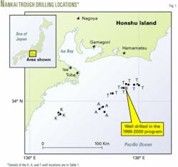
Based on the comprehensive interpretation of 2D and 3D seismic surveys, JNOC selected 16 drilling locations at water depths from 720 m to 2,033 m (Fig. 1). The selection was based on BSRs seen on seismic sections. Some locations showed clear BSRs with different level of amplitude; some had vague BSRs between locations, which had clear BSRs; and some indicated double BSRs. Other locations were characterized by high velocity zones with and without BSRs. Verifying the seismic indication at each location was one of the key objectives of the multi-well exploration program in 2004.
The general plan was designated by JNOC:
1. At each location, an LWD well was drilled to about 100 m below the BSR horizon. In total, 16 LWD wells were drilled at 16 locations.
2. Two of the most hydrate-rich locations were selected and wireline-logged.
3. Several additional hydrate-rich locations were selected and cored at 12 wells. The coring interval was determined based on the closest LWD log.
In addition to the overall hydrate evaluation program, two special missions were included in the 2004 program. One was the experimental program to verify drilling technologies for possible future work. The other mission was the high accuracy borehole-temperature-sensing program, which was planned to obtain precise temperature profiles around the hydrate zone in order to understand the theoretical phase boundaries of hydrates. The concluding article in this series reports operations of both programs.
JNOC project planners scheduled 123 days to accomplish the base program and the two special missions.
Operational prep
In order to execute all programs, drilling operator JAPEX prepared in advance based on experiences in the 1999-2000 program. Fortunately, the scientific drillship used for the Ocean Drilling Program (ODP), Transocean’s6 JOIDES Resolution, and some of her equipment were available because the contract with the ODP was terminated at the end of September 2003.
The JOIDES Resolution was the ideal drilling vessel for the 2004 program because the dynamic positioning system enabled the ship to move efficiently between locations, the riserless drilling system was simple, and the crew was familiar with coring operations.
JAPEX signed the contract with the drillship owner Overseas Drilling Ltd. and discussed the preparation schedule with the drillship operator Transocean. Several modifications were made on the drillship in October-November 2003 in Galveston, Tex., according to JAPEX’s request, such as mounting a remotely operated vehicle (ROV), modifying the pipe handling and racking system for 65⁄8-in. drillpipe, and installing high rate mud mixers.
In Japan, getting approval from the regulatory agencies under the existing mining regulations required many discussions because the scientific drillship didn’t have blowout prevention (BOP) equipment, antiexplosion equipment, or mobile offshore drilling unit (MODU) code certification, all of which are standard in the oil and gas industry. Cooperation from many fishery unions was also required because the 16 drilling locations were spread over many different local unions’ activity areas.
JNOC, JAPEX, Transocean, and all contractors discussed the detailed operations procedures for each element of the program, including logistics, safety concerns, and Japanese regulatory issues, as part of the preparations.
2004 program activities
The JOIDES Resolution left Galveston on Nov. 29, 2003, and arrived at the JAPEX-JNOC operation base in port Gamagori, Aichi Prefecture, Japan on Jan. 18, 2004. After loading necessary equipment and material, it drilled the first well on Jan. 22, 2004.
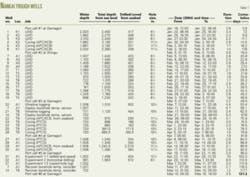
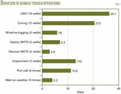
From then until May 18, 2004, a 122-day period, the ship made six port calls and drilled a total of 32 wells at 16 locations. These wells included 16 LWD-logged wells at 16 locations including 2 borehole-temperature-sensed wells, 2 wireline-logged at 2 locations, 12 cored wells at 4 locations, and 2 experimental wells at 2 locations (Table 1). Fig. 2 charts the days allocated to each element of the 2004 hydrate evaluation program.
LWD
Logging while drilling was carried out at each of 16 locations, taking total of 35.1 days for 16 wells. This was the biggest element of the 2004 program, as it would not only provide general information about hydrate occurrence, but it would also provide criteria for selecting location, depth, and survey intervals for the subsequent parts of the exploration program.
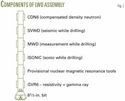
Each hole was drilled with 63⁄4-in. OD LWD tools connected to a 81⁄2-in. bit (Fig. 3). Engineers monitored resistivity, gamma ray, and velocity data in real time while drilling. The other data were stored in the downhole memory of the tools and transferred to a personal computer when the tool was pulled to the surface after each hole was drilled.
To acquire seismic velocities while drilling, the crew hung an air gun from the drillship crane and released 10 shots at 20-sec intervals in surface water during each drillpipe connection (after every 9 m of drilling).
Each LWD logging run was commenced from the seabed at a drilling rate of 60 m/hr. When the real time data showed high resistivity, the drilling rate was reduced to 20 m/hr for denser data acquisition. And when the real time data indicated that the bit had completely passed through the zone of interest, the driller continued for another several dozen meters at 60 m/hr to confirm there were no additional hydrates below.
The decisions about when to change the drilling rate and when to stop drilling were made by JNOC geologists on the drillship. A total of 6,025 m was LWD-drilled in 16 wells, of which 1,228 m was logged at 20 m/hr.
The total downtime due to LWD tool problem was only 11 hr during the entire 35.1-day job because three sets of each tool were prepared on the deck.
All of the 16 LWD logs provided valuable information about how the hydrate occurred generally at each location in comparison with the indications on each seismic section. And two of the most hydrate-rich locations were selected for the following wireline logging, borehole temperature sensing, coring, and experiment program, as well as another two western locations for coring.
Wireline logging
Wireline logging was run at two wells drilled about 20 m from the LWD wells, which had indicated a series of hydrate-rich layers. Based on experiences in the 1999-2000 program, the logging tools were run immediately after quickly drilling each new hole. Otherwise, the hole would enlarge irregularly, preventing the logging tools from running to bottom. Thus, the following procedure was used:
1. Run drilling assembly with a 105⁄8-in., specially designed core bit, which contained a 5.5-in. center bit assembly. Above the bit, the outer barrel of the pressure-temperature core sampler (PTCS) was connected. The PTCS latching and releasing mechanism for the inner barrel was used for the center bit assembly. Several joints of 85⁄8-in. drill collars and 65⁄8-in. drillpipe were connected to the surface, both of which had internal flush 529⁄32-in. ID profile for PTCS coring.
2. Drill the hole to the target depth, as quickly as 20 hr/500 m. Circulate out 5 cu m of gel mud (1.15 sg) to clean the hole at every drillpipe connection on the way to the target depth.
3. At the target depth, displace the drilling mud in the hole with 60 cu m gel of mud (1.15 sg) to keep the hole stable during logging.
4. Pull the drillpipe to locate the bit at about 50 m below the seabed and retrieve the center bit assembly using wireline through drillpipe.
5. Run the wireline-logging tools through the drillpipe to the bottom, and log the open hole below the bit. The wireline heave compensator equipped on the drillship was activated during the logging.
This procedure worked well and all tools were able to reach bottom except the combinable magnetic resonance tool. The CMR tool had a 5.3-in. OD and its strong magnet attracted a lot of small iron particles around the tool on the way inside the drillpipe, which prevented the tool from passing out of the 5.5-in. ID bit.
Crew members made several attempts to remove the iron particles in the pipe by running a magnetic junk catcher and by flushing the pipe at a high pump rate, but attempts to run the CMR at the first wireline-logged well were finally abandoned.
At the second wireline-logged well, this bit was pulled out all the way to surface after drilling the well, and a guide shoe with larger ID was run into the well at 50 m below the seabed. All tools including the CMR could then run through the guide shoe and log the second well successfully.
The Schlumberger logging tools were as follows for the first well (No. 20):
• HALS-MCFL-TLD-CNL-GR.
• HALS-MCFL-TLD-CNL-EMM-GR-SP.
• CMR-GR-EMM.
• FMI-DSI-EMS-GR.
• BARS-EMM-GR.
• VSI-GR (zero offset only).
The quality of all logs was excellent. These logs supplemented LWD log data to identify the physical properties of hydrate-rich and hydrate-poor layers, to verify the seismic interpretation, and to provide depth references for the borehole temperature sensors.
Coring
The objectives of coring in the 2004 program were
• To understand visually the general occurrence of hydrate in the sediment that showed clear or peculiar indication of hydrate on LWD logs.
• To obtain samples in sequence, from the seabed to the target depth, for sedimentological and origin-of-hydrate studies.
• To obtain high quality hydrate-rich samples for laboratory studies.
To achieve these objectives, technicians used two types of core sampling systems at the locations selected by LWD logs.
To accomplish the first objective (general observation), they used an advanced piston corer with extended core barrel (APC/XCB)8 in three wells at two locations.
To accomplish the second objective (full sampling), they used APC/XCB in three wells in the vicinity of the wireline-logged wells at two locations.
To accomplish the third objective (high-quality hydrate sampling), they used a pressure-temperature core sampler (PTCS) in six wells near the wireline-logged wells at two locations where a series of hydrate-rich layers occurred.
In both of APC/XCB and PTCS systems, the inner barrel is retrieved and reset by wireline through drillpipe every time after several meters of core sample were cut into the inner barrel at the bottom of the hole. APC/XCB does not maintain the pressure or temperature of core samples, but its 9.5-m long inner barrel allows quick, effective sampling in soft formations.
The PTCS does maintain the pressure and temperature of core samples so that the dissociation of hydrate in the sample will be minimal, but its 3-m long inner barrel has a complicated mechanism that requires frequent wireline runs, so that the progress is slower than it is with the APC/XCB.
The advanced piston corer cut 2.44-in. OD core samples and the extended core barrel cut 2.312-in. OD samples using an 117⁄16-in. OD bit. The pressure-temperature core sampler cut 2.625-in. OD samples with a 105⁄8-in. OD bit.
The drillship crew was familiar with the APC/XCB system because it was used by the ODP for many years. The crew advised when it was time to change the inner barrel from APC, which extends the piston shoe into very soft formations, to the XCB, which rotates the mill shoe into less soft formations.
The PTCS system was specially designed and developed by Salt Lake City-based Aumann Associates Inc., under a contract with JNOC since 1996, for the purpose of sampling in-situ hydrates. The system was used in the 1999-2000 program, during which a total of 115 m was cut with PTCS and only 46 m were recovered (40%).
Aumann Associates redesigned the system for the 2004 program:
• Eliminating the refrigerating mechanism, leaving just insulating mechanism.
• Improving the ball-valve mechanism for higher reliability to retain pressure.
• Accommodating a plastic liner in the inner barrel.
• Making the outer barrel compatible with a newly manufactured center bit assembly that replaces the inner barrel when drilling ahead.
After testing a prototype, Aumann Associates manufactured three sets of the new pressure-temperature core sampler for the 2004 program. Eight crew members from Aumann Associates Inc. handled the tools on the drillship in two shifts.
Besides redesigning the pressure-temperature core sampler, the PTCS core-handling procedure on the ship was also improved, as follows:
1. When the inner barrel was pulled out to the drillship, it was immediately put into the ice bath for hours before being opened.
2. When a 3-m plastic liner containing core sample was extracted from the inner barrel, a thermo viewer camera traced along the plastic liner to detect the cool sections, which were presumed to contain rich hydrates. The cool sections were marked on the liner with an oil-based felt marker.
3. The plastic liner and core were cut with a disk saw according to the instruction marked on the liner.
4. The marked cool sections were immediately put into the specially designed vessels filled with liquid nitrogen.
5. Sections of the core that were less cool were stored in a refrigerated container after quick observation.
6. The vessels and the freezer container were unloaded at the next port call to transport to laboratories for detailed analysis.
While one set of inner barrels was in the hole, a second set was being cooled in the ice bath, and a third set was being opened and reset for the next run. Since each step took a few hours, the PTCS coring proceeded constantly and efficiently by cycling all three inner barrels.
The quality and the quantity of hydrate-rich core samples taken by PTCS were highly appreciated by the laboratory researchers.
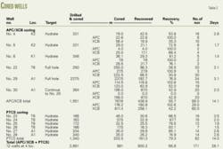
As shown in the list of cored wells (Table 2), a total of 600.2 m of core was taken at 12 wells in four locations over 28.1 days.
The APC/XCB was used in six wells over 14.1 days to cut a total of 1,882 m of 117⁄16-in. hole. Of this, 787.6 m were cored and 438.9-m core sample was recovered (55.7% recovery rate).
The PTCS was used in six wells for 14 days and cut a total of 1,340 m of 105⁄8-in. hole. Of this, 203.5 m were cored and 161.3 m of the core sample were recovered (79.3% recovery rate). Most of hydrate-rich samples were sandstone with the pore space filled with hydrate.
An exception was at a west well, where several centimeters of massive hydrate layers were observed within mudstones. In the laboratory, those samples were analyzed for resource assessment, for effective production potential, and for environmental assessment.✦
References
1. Takahashi, H., Yonezawa, T., Takedomi, Y., “Exploration for Natural Hydrate in Nankai-Trough Wells Offshore Japan,” Offshore Technology Conference Paper 13040, Houston, May 2001.
2. Proceedings of the International Symposium on Methane Hydrates, JNOC-TRC, Chiba, Japan, Oct. 20-22, 1998.
3. Uchida, T., Lu, H., Tomaru, H., and the MITI Nankai Trough shipboard scientists, “Subsurface occurrence of natural gas hydrate in the Nankai Trough area: Implication for gas hydrate concentration,” Resource Geology, Vol. 54 (2004), pp. 35-44.
4. Tsuji, Y., Ishida, H., Nakamizu, M., Matsumoto, R., and Shimizu, S., “Overview of the MITI Nankai Trough Wells: A milestone in the evaluation of methane hydrate resources,” Resource Geology, Vol. 54 (2004), pp. 3-10.
5. Matsumoto, R., Tomaru, H., and Lu, H., “Detection and evaluation of gas hydrate formation in the Eastern Nankai Trough by geochemical and geophysical methods,” Resource Geology, Vol. 54 (2004), pp. 53-68.
6. www-odp.tamu.edu/resolutn.html.
7. http://olc.ebusiness.slb.com/index.asp.
8. www-odp.tamu.edu/dsd/ TOOLS /TOOLS.HTM.
The authors
Hideaki Takahashi (takahs-h@ japex.co.jp) is general manager of the operations department at Japan Petroleum Exploration Co. Ltd., Tokyo. He served as field operation manager of three major hydrate exploration projects: Nankai Trough 2004, Mallik 2002, and Nankai Trough 1999-2000. Takahashi holds a BS in mining engineering (1978) from Waseda University, Tokyo.
Yoshihiro Tsuji (tsuji-yoshihiro @jogmec.go.jp) is the leader of the geoscience research team in the oil and gas technology research and development group at Japan Oil, Gas, and Metals Natl. Corp., Chiba City, Japan. He served as leader of the methane hydrate research project team in the same organization until June 30, 2005, and chaired the Mallik International Symposium held in 2003 at Chiba in which the first hydrate production test results were presented. Tsuji holds a DSc (1993) from Kanazawa University, Japan. He is a member of the Geological Society of Japan, the Japan Association for Quaternary Research, the Japanese Coral Reef Society, and the Japanese Association for Petroleum Technology.
