Subsurface temperature as a passkey for exploration of mature basins: Hot anticlines—a key to discovery?
Temperature anomalies associated with oil-producing structures in the US Midcontinent and similar cratonic areas probably can be used reliably as a passkey for petroleum exploration in mature areas, and thus the concept of hot anticlines could be a key to discovery.
Analysis of accumulated data during the past several decades allows a definition of the problem of hot anticlines. A possible solution for migration and entrapment of petroleum can be explained by the Roberts temperature differential model and the Walters fluid-flow paradigm. In fact, if the Roberts model is valid, higher shallow temperatures, temperature gradients, or heat flow could indicate the entrapment of hydrocarbons at depth.
The recognition and promotion of shallow "hotspots" as an exploration key is not new and was proposed years ago by Haas and Hoffmann,1 Kappelmeyer,2 and as recently as 1986 by Blackwell.3
Use of temperature
Temperature data have not been used extensively in petroleum exploration, but they have been and are important in basin-analysis studies where burial history and the generation of petroleum are of concern.
In today's sophisticated studies, temperature data are utilized in a variety of ways, especially in basin modeling. Thus, until recently, the relation of temperature in the earth to structure in the veneer of sedimentary cover on cratons has been of limited interest.
Some conjecture, however, has been made on a possible relationship since the early days of drilling for oil and gas. Bottomhole temperatures (BHTs) have been measured routinely during wireline logging of boreholes for many years, so a wealth of data is available. As early as the mid 1920s, Thom4 5 and Washburne6 were speculating on the relation of temperature to structure in the US Midcontinent.
US provinces
In the Midcontinent and Rocky Mountains, it has been noted that oil-producing anticlines are warmer than the surrounding areas.
This condition has been recognized for at least 75 years, and it has been discussed both pro and con as a possible exploration passkey. However, there is little evidence, at least in the literature, that temperature has been or could be used as exploration tool with few exceptions.7-10
The Midcontinent oil province has good examples of hot anticlines as almost every if not every oil field has a higher temperature on structure than off. This ranges from giant El Dorado field11-13 in Butler County, Kansas, on the Nemaha anticline to the small Hunter Northwest field14 in Saline County, Kansas, in the Salina basin.
In the Rocky Mountains, in addition to large Salt Creek field in Wyoming,4 reconnaissance surveys of shallow ground temperatures reveal higher values over oil fields.8 Temperature, therefore, with few dissenters, may be a passkey to exploration in mature petroleum provinces.
Every oil field producing from Lower Paleozoic units studied in the Cherokee, Forest City, and Salina basins and along the Nemaha anticline (all in Kansas) shows a temperature anomaly of 10-15° F. (5.6-8.3° C.) on structure. In many instances these oil fields produce from anticlinal features known as plains-type folds.15-17
Recent assessments
Some recent publications discussed the relationship of temperature to the occurrence of petroleum reservoirs.
For example, Ball18 noted a temperature high over the Haverhill oil-producing stratigraphic trap in Butler County, Kansas.
In a series of papers on geothermics in the Midcontinent and on Kansas in particular, Förster and Merriam have explored the subject and cited many examples. 14, 19-24
In addition, several other authors have noted a relation of temperature to oil-producing structures west of Kansas in the Denver basin in east-central Colorado7 8 25 and the Williston basin in eastern Montana and western North Dakota.26
Recently, Fons9 10 proposed that there is a "shadow," that is, a lower temperature, above the producing area in the East Texas oil field; this suggestion is intriguing. The rationale of Fons is that the petroleum in the reservoir forms an insulator so that, although the area under the reservoir may be hot, the area above the reservoir is in a temperature shadow and thus cooler.
Fons suggests this cool shadow area can be used as an exploration tool just as others suggest elevated temperatures in the reservoir can be used.
His approach is to measure temperature in shallow holes to locate an area or areas with this temperature shadow. Unfortunately, this is also in the realm of climate effects and other near-surface disturbances; therefore the concept of a shadow may not be a reliable indicator.
BHTs vs. DSTs and well log databases
It is well known in the petroleum industry that the average temperature of DSTs (drillstem tests) is different than BHTs taken at the same depth in the same stratigraphic unit because of the nature of the test.
Thus, although the DSTs usually are closer to the actual formation temperature, the two temperature populations (DSTs and BHTs) are significantly different statistically and cannot be used intermixed. There are many proposed methods for correcting a BHT to actual formation temperature, but generally each correction factor is applicable only under certain conditions and confined to a specific area.
Geothermal anomalies
Working with regional geothermal or temperature data is similar to the concept of regional dip in structural studies. The regional pattern is background to anomalous values, which in this instance are of immediate interest.
Temperatures measured in boreholes from either uncorrected BHTs, corrected BHTs, or temperatures taken during DSTs, can be plotted for each stratigraphic unit.
It is possible to use uncorrected BHTs for temperature-pattern studies under special conditions, especially if the true formation temperature is not relevant. This allows perusal of large digital petroleum databases for anomalous temperature conditions.
For this application, then, the pattern created by the BHTs is important and not the actual values, which are necessary to interpret the actual geothermal conditions. The pattern can be enhanced by any number of spatial techniques and compared and related to other variables by map comparison/integration techniques to be used for selecting possible drilling prospects.27
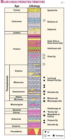
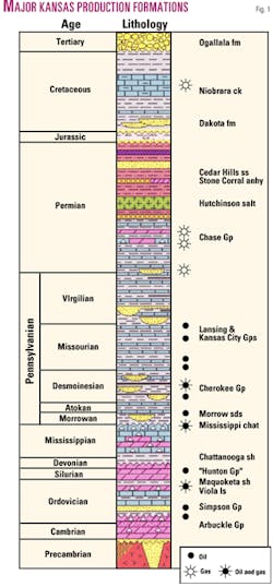
Several of the Paleozoic major producing reservoirs—Cambro-Ordovician Arbuckle, Ordovician Viola limestone, Siluro-Devonian Hunton, and the Mississippian—are fluid conduits in eroded carbonate units overlain by a sealing shale in Kansas (Fig. 1).
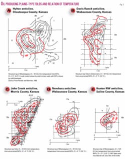
Examples of the coincidence of temperature anomalies and oil-producing anticlines (plains-type folds) are given in Fig. 2. These structures are representative of many features in Kansas and in the Midcontinent.
The temperature anomaly may be slightly offset from the apex of the structure, but this probably is the result of the fluid movement in the reservoir conduit.
Causes of anomalies
Several causes could account for the pattern anomalies created by the geo- thermal conditions.3
1. The heat could be generated by a chemical or biological degeneration of the oil; this was one of the explanations by early workers; conversely the heat could be the result of oil generation within the reservoir.
2. The patterns may be the result of fluid flow through the system. Lateral flow of warm (hot) fluids up out of adjacent deep basins through conduits or vertical flow in the sedimentary section fracture system could account for the temperature distribution.
3. The anomalies may be the result of the insulating affect of the low conductivity of the overlying shale seal beneath which the petroleum is trapped (explaining the overlying "shadow" of Fons9 10).
4. The temperature values seen today could be the result of a thermal event that took place earlier (for example, igneous intrusives in the Mexican oil fields as reported by DeGolyer28). In Kansas near the end of the Cretaceous, elevated heat was locally associated with the emplacement of intrusive igneous plugs. There is no evidence, however, of widespread alteration of sedimentary units in the vicinity and the effect of alteration of sediments adjacent to the plugs themselves is minimal.
5. The higher values could be the result of the distribution of the faulted Precambrian basement blocks over which the sediments have been deposited. But there is no reason to believe that the Precambrian heat-flow values are uniform and the offset in the blocks is on the order of tens of feet, probably not enough relief to account for the pattern based on the difference in elevation alone.
6. The pattern could be the result of the residual heat from the deep burial of the sedimentary section in Permo-Pennsylvanian time, although present temperatures seem to preclude this explanation.
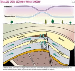
Although it is possible that any one or a combination of factors 1 to 6 could account for the situation, it is only necessary to evoke 2, the so-called Roberts model29 to explain the situation. The Roberts model (Fig. 3) would seem to offer the best single solution to the dilemma to the anomalous temperature conditions assuming warm fluids are migrating laterally up out of deeper parts of the basin through conduits containing the reservoir à la the Walters paradigm of differential entrapment.30
Roberts' proposed model is based on the premise that where fluids are trapped in a reservoir, the water will escape vertically at the apex of the structure through a porous membrane while the hydrocarbons will be retained. This requires a combination of reservoir seal, capillary barrier, fluid movement, and rock fracture system, which causes a change in temperature, pressure, and salinity.
This creates a dynamic system that maintains the higher temperature as long as the migrating fluids maintain their flow and temperature. This would account for the heat anomalies in and over the reservoirs.
Acknowledgments
Willard (Bill) Guy and Martin Dubois of the Kansas Geological Survey made suggestions to improve the content and presentation.
References
1. Haas, I.O., and Hoffmann, C.R., "Temperature gradient in Pechelbronn oil-bearing region, Lower Alsace: its determination and relation to oil reserves," AAPG Bull., Vol. 13, No. 10, 1929, pp. 1,257-73.
2. Kappelmeyer, O., "The use of near surface temperature measurements for discovering anomalies due to causes at depths," Geophys. Prospecting, Vol. 5, No. 3, 1957, pp. 239-258.
3. Blackwell, D.D., "Use of heat flow/temperature measurements, including shallow measurements, in hydrocarbon exploration," in Davidson, M.J., ed., "Unconventional methods in exploration for petroleum and natural gas," SMU Press, Dallas, 1986, pp. 321-350.
4. Thom, W.T., Jr., "Relation of earth temperatures to buried hills, and anticlinal folds," Econ. Geology, Vol. 20, No. 6, 1925, pp. 524-530.
5. Thom, W.T., Jr., "Earth temperatures, buried hills, and anticlinal folds (discussion)," Econ. Geology, Vol. 22, No. 1, 1927, pp. 91-94.
6. Washburne, C.W., "Relation of earth temperatures to buried hills and anticlinal folds (discussion)," Econ. Geology, Vol. 21, No. 4, 1926, pp. 397-399.
7. Meyer, H.J., and McGee, H.W., "Oil and gas fields accompanied by geothermal anomalies in Rocky Mountain region," AAPG Bull., Vol. 69, No. 6, 1985, pp. 933-945.
8. McGee, H.W., Meyer, H.J., and Pringle, T.R., "Shallow geothermal anomalies overlying deeper oil and gas deposits in Rocky Mountain region," AAPG Bull., Vol. 73, No. 5, 1989, pp. 576-597.
9. Fons, L., "Temperature method can help locate oil, gas deposits," OGJ, Apr. 12, 1999, pp. 58, 60-64.
10.Fons, L., "Temperature anomaly mapping identifies subsurface hydrocarbons," World Oil, Vol. 221, No. 9, 2000, p. 65.
11. Fath, A.E., "Geology of the Eldorado oil and gas field, Butler County, Kansas," Kansas Geol. Survey Bull. 7, 1921, 187 p.
12. McKenna, J.R., and Blackwell, D.D., "Thermal regime of a large Midcontinent oil field (Butler County, Kansas) from high-resolution temperature logs," Okla. Geol. Survey Circ. 106, 2001, pp. 151-161.
13. McKenna, J.R., Merriam, D.F., and Blackwell, D.D., "Thermal regime of the Midcontinent El Dorado oil field (Kansas) interpreted from high resolution temperature logs," abs. AAPG annual convention, Dallas, 2004, p. A94.
14. Merriam, D.F., and Förster, A., "Subtle and not-so-subtle anticlinal structures and their geothermal overprint in the Salina Basin, north-central Kansas," AAPG Midcontinent Regional Meeting (Wichita), Transactions, 1999, pp. 15-21.
15. Merriam, D.F., and Förster, A., "Precambrian basement control on 'plains-type folds' (compactional features) in the Midcontinent region, USA," in Oncken, O., and Janssen, C., eds., Basement Tectonics 11: Kluwer Acad. Publ., Dordrecht, 1996, pp. 149-166.
16. Merriam, D.F., "'Plains-type folds' in the Midcontinent region (USA): chronicling a concept," Jour. Earth Science History, Vol. 18, No. 2, 1999, pp. 264-294.
17. Merriam, D.F., "Exploring for petroleum in the Flatlands: history of oil and gas exploration in Kansas," Oil-Industry History, Vol. 3, No. 1, 2002, pp. 56-71.
18. Ball, S.M., "Exploration application of temperatures recorded on log heading—an up-the-odds method of hydrocarbon-charged porosity prediction," AAPG Bull., Vol. 66, No. 8, 1982, pp. 1,108-23.
19. Förster, A., and Merriam, D.F., "Geothermal field interpretation in south-central Kansas for parts of the Nemaha Anticline and flanking Cherokee and Sedgwick Basins," Basin Research, Vol. 5, No. 4, 1993, pp. 213-234.
20. Förster, A., and Merriam, D.F., "Analyzing low-amplitude folds in simple geological environments," in Pawlowky-Glahn, V., ed., Proc. IAMG '97, Pt. 1: Intern. Ctr. for Num. Methods in Eng., Barcelona, Spain, 1997, pp. 331-336.
21. Förster, A., and Merriam, D.F., "Problems and potential of industrial temperature data from a cratonic basin environment," in Förster, A., and Merriam, D.F., eds., "Geothermics in Basin Analysis," Plenum Press, New York, 1999, pp. 35-59.
22. Förster, A., Merriam, D.F., and Hoth, P., "Geohistory and thermal maturation in the Cherokee Basin (Midcontinent, USA)—results from modeling," AAPG Bull., Vol. 82, No. 9, 1998, pp. 1,673-93.
23. Förster, A., Merriam, D.F., and Watney, W.L., "Temperature analysis in the mature hydrocarbon province of Kansas: utilizing a large database of well-completion histories," in Merriam, D.F., and Davis, J.C., "Geologic Modeling and Simulation: Sedimentary Systems," Kluwer Acad./Plenum Press, New York, 2001, pp. 285-301.
24. Merriam, D.F., and Förster, A., "Origin, development, and distribution of 'plains-type folds' (compactional features) in the Cherokee Basin of the American Midcontinent," Okla. Geol. Soc. Trans. (proc. AAPG Midcontinent Meeting, Oklahoma City), 1997, pp. 52-56.
25. Kelley, S.A., and Blackwell, D.D., "Subsurface temperatures in the southern Denver Basin, Colorado," Rocky Mountain Geology, Vol. 37, No. 2, 2002, pp. 215-227.
26. Moore, R.W., "Distribution of hydrocarbons in the Williston Basin," abs., AAPG Bull., Vol. 84, No. 8, 2000, pp.1,242.
27. Förster, A., and Merriam, D.F., "Some aspects of geothermics in basin analysis," Intern. Assoc. Math. Geology Ann. Conference, Papers and Extended Abstracts Tech. Program, Mount Tremblant, Que., 1994, pp. 134-140.
28. DeGolyer, E.L., "The significance of certain Mexican oil field temperatures," Econ. Geology, Vol. 13, 1918, pp. 275-301.
29. Roberts, W.H., III, "Some uses of temperature data in petroleum exploration," in Gottlieb, B.M., ed., "Unconventional methods in exploration for petroleum and natural gas," SMU Press, Dallas, Tex., 1981, pp. 8-49.
30. Walters, R.L., "Differential entrapment of oil and gas in Arbuckle dolomite of central Kansas," AAPG Bull., Vol. 42, No. 9, 1958, pp. 2,133-73.
The author
Dan Merriam (dmerriam@ kgs.ku.edu) is a senior research scientist (emeritus) with the Kansas Geological Survey at the University of Kansas. A former distinguished professor at Syracuse University and Wichita State University, for the past decade he has been studying the structure and structural development of plains-type folds in the Midcontinent and the relation of the subsurface temperature field to these features and the occurrence of petroleum. He has over 50 years' experience in Kansas and Midcontinent geology.


