Southwestern Iraq gas traps contain recoverable reserves
Muhammed Abed Mazeel
Sameer Noori Ali
Maitham Mezher Razzaq
Iraq Ministry of Oil
Baghdad
Four Khabour formation stratigraphic gas traps in the Gilgamesh area have been identified for production with expected ultimate recoverable reserves of 4.7 tcf and estimated 6.5%/year decline. Potential gas traps of the Paleozoic Khabour formation in southwestern Iraq were evaluated using 2D seismic survey interpretations, analogous reservoir properties, and geological and reservoir engineering experience in the area.
The regional development plan calls for 28 wells. Well designs were optimized from offset Akkas-field well data. Estimated well costs are $12 million/well. Based on this study, the Ministry of Oil (MoO) expects to develop these gas traps with international oil companies.
Analog Iraqi gas traps
The Paleozoic in the southwestern Iraq desert contains potential dry gas and gas-condensate reservoirs with Ordovician sandstones in the Khabour formation and Silurian sandstones in the Akkas formation. The Khabour formation was discovered by Wetzel in 1950 and showed an 800 m section exposed in the Khabour valley within the Ora Zone. It is the oldest known Paleozoic formation in Iraq. The Akkas formation overlies the Khabour formation and underlies the Devonian.
Khabour comprises thin-bedded fine-grained quartzite, siltstone, and micaceous shale. The formation is comprised of beds of sandstone and shale at about 2,326-m drilled depth and 1,250-m thickness in the Jezira subzone in well Khlesia-I and at 1,913-m drilled depth and 1,248-m thickness in the Rutba subzone in well Akkas-l. It exhibits good reservoir properties. The lowermost 500 m of the Khabour formation in Akkas-l comprises shale. Equivalent formations are Swab (1,025 m thick, in Syria), Afendi (1,500 m thick, in Syria), Qasim (1,680 m thick, in Saudi Arabia), and Umm Tarifa (748 m thick in Wadi Sirhan, Jordan).
Scanning electron microscopic analysis of sandstone samples from Akkas-1 identified extensive microporosity and good pore connectivity, suggesting that these sandstones have the potential to form hydrocarbon reservoirs. Paleozoic reservoirs of trapped oil that followed similar migration pathways are expected in Iraq’s southwestern desert. High gravity oil (42° API) is present in the Silurian Akkas sandstone reservoirs, and sweet gas occurs in the upper sandstones of the Ordovician Khabour formation.
Geology
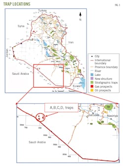
The study area is in the southwestern part of Iraq within the administrative borders of Najaf Governorate, 10-12 km from the Iraqi-Saudi border (Fig. 1). Four structures (A-D) lie in the Gilgamesh area which contains the main Ordovician-age Khabour formation. Gilgamesh is shallower in the study area than in western Iraq.
Gilgamesh’s analog Khabour formation is of variable bed thickness and lithology, containing dark gray and black shale, gray and white sandstones, and siltstones.
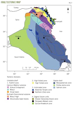
The most important units are the first unit (upper sand reservoir) and the fifth unit (lower sand reservoir), which consist mainly of fine-grain sandstones with medium hardness, interbedded with layers of shale. Tectonically, the study area is on the Stable Shelf of the Arabian plate within the Rutba subzone of the Rutba-Jezira zone (Fig. 2). The area is in the Ga’ara Depression in the Western Desert, which is bounded directly to the northeast by the Anah Graben. To the south is the northern margin of the Ga’ara Arch which separates it from Widyan basin.
Although the Iraqi Western Desert belongs to the Stable Shelf, tectonic and structural effects have controlled the type of exposed rocks, thickness, and extension of the formations. The Rutba Uplift and Ga’ara Depression have exposed Permian rocks followed by Triassic and Jurassic rocks which are absent in other parts of the Iraqi Western Desert and surrounding areas, even in nearby areas of the neighboring countries.
The Rutba Uplift also has affected the type of exposed rocks, causing lateral facial changes due to changes in the depositional basin. On the other hand, Nukhaib Graben caused deposition of huge amounts of gravel deposits and Pliocene-Pleistocene rocks of the Zahra formation, dividing some depositional basins.
Petrophysics
Core analysis in the Khabour formation indicated an average porosity of 10% and core permeability ranging from 0.03-0.2 md. Grain density varied from 2.61-2.78 g/cu cm with an average grain density of 2.68 g/cu cm.
Formation temperature is 146° C. at 3,300 m, and the temperature gradient from temperature log within Khabour formation is about 2.28° F./100 ft. Radioactivity causes the high Silurian shale temperature, and it decreases in the Khabour formation to normal gradients.
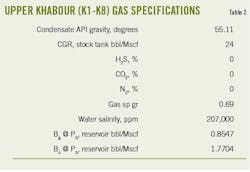
Water obtained from Akkas-4 and Akkas-5 analogs contains 100,000-207,000 ppm salinity. There were no traces of H2S in Khabour bottom-hole samples. Production tests were from Akkas-1, Akkas-2, Akkas-3, and Akkas-4 wells. Hydrocarbon compositions were measured at surface conditions.
Source rock, traps
The petroleum system in Paleozoic and Cretaceous ages in southern and southwestern Iraq contains good source rock, reservoirs, and seal rocks which lead to the existence of several traps. Geological, geophysical, and petrophysical data and analogs from Akkas field were used to characterize the Paleozoic petroleum system in terms of source rock, reservoir rock, seal rock, and traps to determine hydrocarbon potential. Paleozoic source rocks in Iraq consist of Khabour, Akkas, and Ora formation shales. Sandstones of Khabour formations displayed good reservoir potential.
Thamer Al-Ameri studied samples in 2007 from depths of 2,750-3,000 m from the Akkas-1 borehole and found total organic content (TOC) of 0.71–1.42 wt.%. Biodegradation and thermal alteration of the organic matter resulted in abundant amorphous organic matter of about 70-75%. The thermal alteration index (TAI) is 3.8 as evidenced by a dark brown acritarch. This organic matter therefore can generate wet gas and condensate according to its organic matter levels and thermal degradation.
Traps of Khabour and Akkas formations are structural, created by a faulted anticline trending northwest to southeast. The overlying Silurian shale of the Akkas formation is an effective local regional seal. A 2D seismic survey and Akkas well results identified four traps in the Khabour formation:
- Structure A. 10 km from the Iraqi-Saudi border. Its length is 5.1 km and width is 3.63 km.
- Structure B. 10 km from the Iraqi-Saudi border. Its length is 10.9 km and width is 7.3 km.
- Structure C. 11 km from the Iraqi-Saudi border. Its length is 10 km and width is 8.5 km.
- Structure D. 12 km from the Iraqi-Saudi border. Its length is 7.5 km and width is 4.5 km.
Forecasts
Petrophysical properties and recoverable resources are listed in Table 1. Reserves were estimated based on preliminary deterministic volumetric calculations. Pmean recoverable values have been generated using recovery factor and gas in place volumes for each prospect considered in the four areas. It is assumed that all prospective areas contain gas-condensate. Recoverable volumes are estimated at 17.3 million stb/well condensate and 145 bcf/well gas.
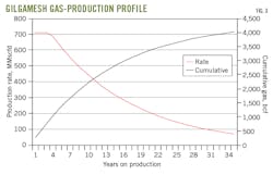
Gas and condensate plateau rates vary by field. Duration of plateau production averages 8 years for gas and 7 years for condensate. These assumptions are based on analog field production history. Fig. 3 shows the gas production forecasts for the four prospects based on geophysical and geological evaluation assumptions and known reservoir properties of analogous reservoirs. The condensate production profile is similar.
Field development plan
Iraq’s production strategy is to use the gas to satisfy domestic demand, which is about 6 bscfd. Produced associated gas totals 3.9 bscfd, but only 48% of it is used and more than half is burned off because of a lack of adequate gas capturing, processing, and transportation infrastructure. MoO has contracted companies to capture remaining associated gas to achieve zero gas flaring by 2028.
The proposed development plan for the prospects can be divided into phases to keep costs viable and understand reservoir behavior. Gas specifications for the target formation are shown in Table 2. The first phase will start at 250 MMscfd and increase until it reaches 700 MMscfd. The agreed gas price will be paid from MoO to the operator. Surplus gas will be exported.
Drilling, completion
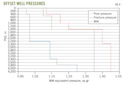
Offset well data from Akkas field provides lessons learned for optimum well design to minimize non-productive time and reduce overall well times and costs. Casing design originates from offset-well pore pressure and fracture gradients (Fig. 4). Temperature profile comes from an offset-well temperature log.
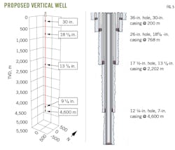
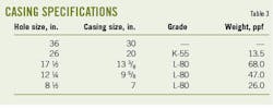
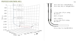
Additional experience from ongoing field operations and more detailed sub-surface information will modify and optimize future well design. Proposed well designs include both vertical (Fig. 5) and horizontal (Fig. 6). Casing specifications for vertical and horizontal well are shown in Table 3. Expected gas well drilling and completion time is 45 days, in accordance with international drilling practices.
Cost estimates
Several prospects identified in each block have different hydrocarbon presumption classifications. Generally, all identified prospects were estimated on a standalone basis in which most resources have their own committed gas-oil separation plant. It is assumed that the large gas resources identified in the area around the prospects will be partially used for Iraqi electric power generation, petrochemical production, private sector basic industry, and export via Turkey to Europe or liquefaction at Ceyhan, Turkey, or Basra, Iraq.
Drilling costs were estimated from similar wells drilled in Iraq by international service companies. Average well cost is $12 million/well. Cost variances include targets at different depths (Table 4) and variations in well type. Indirect costs were applied at a standard rate of 20% of base costs.
Total costs for Gilgamesh development include:
- Drilling (exploration, appraisal, and development wells).
- Group-of-service suppliers expenditures.
- Gas oil-separation and gathering systems.
- Export and tie-in pipelines.
- Camp infrastructure and security costs.
- Indirect costs.
Contingency allowance was applied at a rate of 25% of base and indirect costs (Table 5) for total estimated capital expenditure of $2.79 billion to develop the four reservoirs.
Bibliography
Al-Ameri, T. and Wicander, R., “An assessment of the gas generation potential of the Ordovician Khabour Formation, Western Iraq,” Comunicações Geológicas, V. 95, 2008, pp. 157-166.
Al-Hajri, S.A. and Owens, S.B., “Sub–surface palynostratigraphy of the Palaeozoic of Saudi Arabia,”, Special GeoArabia Publication, Vol. 1, Gulf Petrolink, Bahrain, 2000.
Al-Husseini, M., “Preliminary chronostratigraphic chart of the Gulf Region,” Gulf Petrolink Bahrain, 2000.
Al-Juboury, A.I. and Thani, M.A.M, “Silurian Gas-Rich ‘Hot Shale’ from Akkas Gas Field, Western Iraq: Geological Importance and Updated Hydrocarbon Potential and Reservoir Development Estimations of the Field,” Shale Gas, IntechOpen, Aug. 29, 2018.
Al-Juboury, A.I., Howard, J.P., Nichols, G., Vincent, S.J., Manning, C., and Vautravers, B.P., “Sedimentology, geochemistry and reservoir potential of sandstones in the Silurian Akkas formation, Western Iraq,” Journal of Petroleum Geology, Vol. 42, June 11, 2019, pp. 261-279.
Al-Sharhan, A.S. and Nairn, A.E.M., “Sedimentary Basins of Petroleum Geology of the Middle East,” Elsevier, Holland, 1997.
Fox, J.E. and Ahlbrandt, T.S., “Petroleum geology and total petroleum systems of the Widyan Basin and Interior Platform of Saudi Arabia and Iraq,” Bulletin 2202-E, USGS Publications Warehouse, 2002.
Jassim, S.Z. and Goff, J.C., “Geology of Iraq,” Dolin, Prague and Moravian Museum, 1st Ed., Brno, printed in the Czech Republic, 2006.
Mazeel, M., “Hydrocarbon potential, reservoir development estimated for western Iraq’s Akkas gas field,” OGJ, Oct. 3, 2011, p. 86.
Mazeel, M., “Siba Gas Field Development Plan: Subsurface Uncertainties and Economic Criteria,” Middle East Economic Survey, Vol. 53, No. 27, 2010.
Sissakian, V.K. and Mohammed, B.S., “Stratigraphy,” in “Geology of the Iraqi Western Desert,” Iraqi Bulletin of Geology and Mining, Special Issue, 2007, pp. 51-124.
The authors
Dr Muhammed Abed Mazeel ([email protected]) is director general of the reservoirs and fields development directorate (RFDD) for the MoO. He has a PhD (1993) in petroleum engineering from the University of Clausthal-Zellerfeld in Germany and a PhD (2018) in management and marketing from Bradford University in the UK. He also holds an MS (1989) from the Escuela Superior de Minas in Madrid.
Dr Sameer Noori Ali ([email protected]) is head of department south reservoir engineering at the RFDD for the MoO. He has a PhD (2004) from the university of Baghdad.
Maitham Mezher Razzaq al-Aqeili ([email protected]) is head of drilling and operations for the MoO. He holds a BS (2007) in petroleum engineering from the Baghdad University College of Engineering and is a certified international well drilling trainer.
