Bakken, Three Forks largest continuous US oil accumulation
Stephanie B. Gaswirth
Kristen R. Marra
US Geological Survey
Central Energy Resources Science Center
Denver
The recent reversal of the declining trend of US oil production is largely due to production from unconventional or "continuous" low-permeability reservoirs by use of multistage hydraulic fracturing of horizontal legs of exploration wells. The US currently produces about 7.4 million bo/d, and the increasing trend in domestic production has led to speculation that the US could become energy independent in oil in the near future.
The US still imports an additional 11 million bo/d to meet consumption requirements).1 Critical to the discussion of energy independence are estimates of resources contained in low-porosity and low-permeability (or "tight") continuous oil and gas accumulations, which have formed a critical component of national energy policies in recent years.
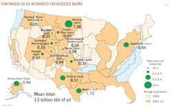
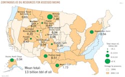
The US Geological Survey (USGS) assesses the potential for remaining domestic hydrocarbon resources in both continuous and conventional accumulations, making the USGS the sole provider of publicly available geologic-based estimates of undiscovered, technically recoverable resources of the US. The USGS recently assessed the Bakken and Three Forks formations "tight" oil resources and estimate these as some of the largest undiscovered, technically recoverable oil accumulations in the US (Fig. 1).2
Bakken, Three Forks formations
The Devonian-Mississippian Bakken and the Devonian Three Forks formations lie in the Williston basin province, which includes the western two-thirds of North Dakota, the northwestern corner of South Dakota, northeastern Montana, and extends northward into the Canadian provinces of Saskatchewan and Manitoba.
Oil was first discovered in the Williston basin in the early 1950s and total cumulative oil production to date from the US part of the basin is about 3.6 billion bbl of oil.3 Over the first 50 years, about 150 million bbl of oil were produced from the Bakken formation with vertical drilling practices.4
In the past decade, production from the Bakken was augmented by use of horizontal drilling combined with hydraulic fracturing of the wellbore. To date, the Bakken formation has produced more than 775 million bbl of oil from wells in North Dakota and Montana.3 Combined with the underlying and recently exploited Three Forks formation, which has produced about 150 million bbl of oil to date, these two formations have produced about 22% of the total cumulative oil production from the US portion of the Williston basin. In the past decade, the Bakken and Three Forks formations have accounted for more than 80% of the Williston basin's annual production.3
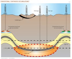
The Bakken and Three Forks formations within the US part of the basin were assessed for both conventional and continuous oil accumulations. Conventional accumulations occur where oil is buoyant upon water, creating discrete resource accumulations that have migrated into structural or stratigraphic traps with adequate reservoir properties (Fig. 2).
In contrast, a continuous oil accumulation is defined to include oil that is generated from thermally mature organic-rich shale that remains in or adjacent to the source rock with minimal migration. Such continuous accumulations are referred to as "shale oil" or "tight oil," depending upon whether the oil is produced from the shale itself or from adjacent tight reservoirs.
In addition, continuous accumulations can commonly include shale gas, tight gas, and coalbed gas (Fig. 2). Continuous accumulations are regionally extensive, and hydrocarbons are produced with horizontal wells and hydraulic fracturing of the reservoir to expose a greater surface area of the reservoir rock to the wellbore in order to stimulate oil and gas flow.
Geologic assessment
The USGS last assessed the Bakken formation in 2008, coincident with the beginning of the current oil boom in the Williston basin.5 Since that time, petroleum production and the number of wells in the Bakken formation have continued to increase (more than 5,000 new wells) in Montana and North Dakota. In addition, the Three Forks formation, which had limited production data and therefore was not assessed in 2008, has experienced substantial growth in the number of producing wells (more than 1,000 since 2006).
Data from these new wells have led to an increased understanding of the Bakken and Three Forks geologic heterogeneities and production potential. New technology and well completion techniques since the 2008 assessment have also enhanced recovery from Bakken and Three Forks formation wells.
As a result of the oil boom and increased political interest in oil reserves of the Williston basin, the USGS formally reassessed the Bakken formation in 2013. The assessment also included an initial examination of the underlying Three Forks formation.2 The assessment methodology delineated a Total Petroleum System (TPS), which outlines the area that encompasses genetically related petroleum that has been generated by a pod of mature source rock.6
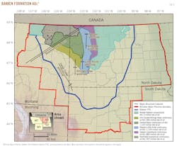
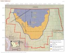
The Bakken TPS consists of strata from the Devonian Three Forks formation, Devonian-Mississippian Bakken formation, and lower part of the Mississippian Lodgepole formation that contains Bakken-sourced oil.7 Subsequently, assessment unit (AU) areas were established based on mappable volumes of rock within a TPS encompassing areas that share similar geologic traits and stratigraphic factors.6 For the 2013 assessment, six continuous AUs and two conventional AUs were defined in the Bakken TPS (Figs. 3 and 4).
Five of the continuous AUs and one conventional AU are in the Bakken formation, and one continuous and one conventional AU are in the Three Forks formation (Figs. 3 and 4). The Bakken AUs are similar to those defined for the 2008 assessment; modifications reflect geologic insights gained during the past 5 years of drilling activity.
Boundaries of the five continuous AUs were also adjusted from those of the 2008 assessment in order to incorporate new geologic datasets. These datasets include newly analyzed thermal maturity data from the upper shale member,8 new production data in the northeastern part of the assessment area (Eastern Transitional AU), and production data showing increased water saturation in the northwestern portion of the basin.
Within each of the AUs, the assessment methodology incorporates "sweet spot" areas, which are regions that have optimal geologic characteristics for hydrocarbon recovery.9 Delineation of the "sweet spot" areas for the Bakken formation was largely based upon areas where the Bakken shale members are thermally mature, the petroleum system is overpressured, and structural features that enhance production are present.
The Three Forks continuous oil AU has been proven in the central part of the basin and is defined by the area overlain by the upper and lower Bakken shale members (Fig. 4).
The "sweet spot" area for the Three Forks continuous AU encompasses the region of maximum hydrocarbon generation based on Bakken formation thermal maturity maps, maximum formation pressures, and structural enhancements related to lineaments and the Nesson and Little Knife anticlines. The Pronghorn member of the Bakken formation, where present, is also included within the Three Forks continuous oil AU.
At present, production from the Three Forks formation is concentrated in the central part of the basin, particularly the regions underlying the Nesson–Little Knife and Eastern transitional AUs defined for the Bakken formation. Production from the Three Forks formation is also largely restricted to the upper section of the unit, where tight reservoir rock is close to the overlying Bakken formation shale members.
The region of production from the Three Forks formation is likely to expand as well as deepen into the formation as more wells are drilled, geologic models are tested, and exploration continues.
There has been no successful drilling in the Bakken and Three Forks conventional AUs to date; the assessment of these conventional AUs is hypothetical and based on conventional oil accumulation analogs from Bakken production in Saskatchewan and Manitoba.
Total oil resource
The combined mean total oil resource of the 2013 USGS Bakken and Three Forks formations assessment is 7.38 billion bbl of oil, with 3.65 billion bbl of oil attributed to the Bakken formation and 3.73 billion bbl of oil attributed to the Three Forks formation.
The conventional oil component of this estimated resource is negligible (1% of the total estimated resource). This estimated undiscovered, technically recoverable resource makes the Bakken–Three Forks system the largest continuous oil accumulation in the US, as assessed by USGS, and it accounts for more than half of all domestic-assessed tight oil resources (Fig. 3).
By comparison, the second largest continuous oil accumulation in the US is the combined resources of the Eagle Ford Shale and Austin Chalk in the Western Gulf Basin Province (Texas and Louisiana), which was assessed at 1.7 billion bbl of oil.10
EIA has estimated US consumption of oil at about 6.9 billion bbl of oil/year, making the Bakken–Three Forks total resource potential at the mean estimated amount equal to about a 1-year supply of US resource consumption at the current rate.1
Using ranges of undiscovered resources, estimated ultimate recoveries (EURs), and drainage areas,2 USGS estimates that at the mean, about 40,000 wells would be required to recover this resource, with a range from 18,000 to 71,000 wells possible. At the 2012 rate of drilling and, assuming no changes in drilling rates, economics, or other variables, this resource could take 20 or more years to develop and recover.
Acknowledgements
Thanks are due to W. Husband for figure drafting and C. Schenk, R. Dubiel, and O. Pearson for comments on earlier versions of the manuscript.
References
1. US Energy Information Administration, Statement of A. Sieminski to the Committee on Energy and Natural Resources, US Senate, Washington, DC; http://www.eia.gov/pressroom/testimonies/sieminski_07162013.pdf (August 2013).
2. Gaswirth, S.B., Marra, K.R., Cook, T.A., Charpentier, R.R., Gautier, D.L., Higley, D.K., Klett, T.R., Lewan, M.D., Lillis, P.G., Schenk, C.J., Tennyson, M.E., and Whidden, K.J., "Assessment of undiscovered oil resources in the Bakken and Three Forks Formations, Williston Basin Province, Montana, North Dakota, and South Dakota," US Geological Survey Fact Sheet, 2013-3013.
3. IHS Energy Group, Petroleum Information Database; IHS Inc., Englewood, Colo., 2013.
4. IHS Energy Group, Petroleum Information Database; IHS Inc., Englewood, Colo., 2007.
5. Pollastro, R.M., Cook, T.M., Roberts, L.N.R., Schenk, C.J., Lewan, M.J., Anna, L.O., Gaswirth, S.B., Lillis, P.G., Klett, T.R., and Charpentier, R.R., "Assessment of undiscovered oil resources in the Devonian-Mississippian Bakken Formation, Williston Basin Province, Montana and North Dakota," US Geological Survey Fact Sheet, (April 2008), 2008-3021.
6. Klett, T.R., Schmoker, J.W., Charpentier, R.R., Ahlbrandt, T.S., and Ulmishek, G.F., Glossary, Chapter GL in US Geological Survey World Petroleum Assessment 2000, Description and Results by US Geological Survey World Energy Assessment Team; US Geological Survey DDS-60; 2000.
7. Lillis, P.G., "Review of oil families and their petroleum systems of the Williston Basin," Mountain Geologist, Vol. 50, No. 1 (January 2013), pp. 5-31.
8. Lewan, M.D., Marra, K.R., Lillis, P.G., Higley, D.K., and Gaswirth, S.B., "Mapping the extent and distribution of oil formation in the Upper Bakken Formation, Williston Basin" [abs.], American Association of Petroleum Geologists Search and Discovery Article #90163; May 22, 2013.
9. Bakken-Three Forks Assessment Team, "Input-form data for the US Geological Survey assessment of the Devonian and Mississippian Bakken and Devonian Three Forks Formations of the US Williston Basin Province," US Geological Survey Open-File Report, (April 2013), 2013-1094.
10. Pearson, K., Dubiel, R.F., Pearson, O.N., and Pitman, J.K., "Assessment of undiscovered oil and gas resources of the Upper Cretaceous Austin Chalk and Tokio and Eutaw Formations, Gulf Coast," US Geological Survey Fact Sheet (June 2011); 2011-3046.
The authors
Stephanie B. Gaswirth ([email protected]) is a research geologist with the Central Energy Resources Science Center of the US Geological Survey in Denver and has worked on resource assessments in the Williston and Anadarko basins. She worked for ExxonMobil Upstream Research Company prior to joining the USGS in 2006. Gaswirth holds degrees in geology: a BA (1997) from Franklin & Marshall College, Lancaster, Pa.; an MS (1999) from Rutgers University; and a PhD (2004) from the University of Colorado, Boulder.
Kristen R. Marra ([email protected]) is a geologist with the Central Energy Resources Science Center at the USGS Denver office. Before joining the USGS in 2011, she worked for QEP Energy Co., Tulsa. Marra holds BS (2005) and MS (2008) degrees from and is a PhD candidate at the University of Oklahoma.
