More explorers lining up off northwestern Africa
More exploration companies are lining up to explore the Atlantic margin off Northwest Africa.
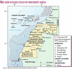
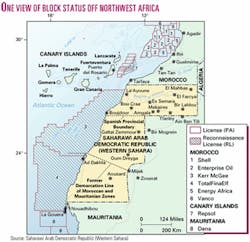
Relatively little drilling has taken place along a coastline of about 1,500 miles from the Senegal-Mauritania border north to the Strait of Gibraltar, and no offshore production has been established. Still, a significant portion of the shelf and a lesser share of the deepwater area are under license.
Part of the area is the subject of a long-running border dispute between Morocco and Western Sahara.
Western Sahara
Fusion Oil & Gas PLC, London, said it will undertake a comprehensive geological and geophysical study in the Atlantic Ocean off Western Sahara, Africa, where Morocco granted reconnaissance licenses to two companies in October 2001.
Fusion said it signed an exclusive technical cooperation agreement with the government of the northwest African state of Western Sahara. The 210,000 sq km area extends from Mauritania to Morocco and the Canary Islands. Fusion said the study will take up to 16 months.
Morocco last fall granted a 110,400 sq km block off Western Sahara to a unit of Kerr-McGee Corp., Oklahoma City, and an adjoining 115,000 sq km block to a unit of TotalFinaElf SA, Paris.
Western Sahara authorities, referring to the area as Saharawi Arab Democratic Republic (SADR), said, "These exploration awards, made by the Moroccan occupying regime under Moroccan law, will have no legitimacy under the future independent Saharawi State."
What's planned
Fusion obtained the right, after completing its studies on behalf of SADR, to nominate as many as three areas of as much as 20,000 sq km each for future exploration licensing on regionally competitive terms.
The study process will assist the government "to better understand the offshore oil and gas potential of the area and formulate appropriate policy to attract international investment."
The licenses would be awarded within 6 months of SADR joining the United Nations.
Fusion said a preliminary assessment of historical data suggests that a similar gross stratigraphic sequence to that encountered in Fusion's licenses to the south off Mauritania, The Gambia, Senegal, and Guinea Bissau can be anticipated.
The company said it has been in consultation more than 3 years with the government concerning a collaborative assessment of SADR's offshore oil and gas potential.
Fusion noted that it is one of the largest holders of exploration acreage off Northwest Africa. Woodside Petroleum (Pty.) Ltd., Perth, Australia, and Fusion announced an oil and gas discovery off Mauritania in May 2001 at their first frontier exploration well in the region, Chinguetti-1 (OGJ, Jan. 21, 2002, p. 30). Chinguetti lies 250 miles south of Western Sahara waters.
Seismic survey
TGS-NOPEC Geophysical Co., Oslo, began acquiring seismic data off Boujdour and Dakhla.
The company's Northern Access seismic vessel is acquiring 15,000 line km of nonexclusive 2D seismic data in the area.
The survey resulted from a bid process initiated by two oil companies, TGS-NOPEC said. The geophysical contractor pointed out that it is honoring contractual obligations and that it has no interest in nor would it profit from exploratory drilling if any occurs.
TGS-NOPEC said, "The United Nations Security Council has considered issues surrounding the contracts held by oil companies for the right to explore for hydrocarbons in these areas. These contracts include provisions for acquisition of seismic data.
In a letter dated Jan. 29, 2002, from the Under-Secretary-General for Legal Affairs, the Legal Council, to the President of the Security Council, the opinion is expressed that the contracts are legal. The letter does express concern regarding potential further development and exploitation of hydrocarbons beyond the scope of the existing contracts."
The offshore area claimed by Western Sahara extends from shore with western portions in more than 3,000 m of water. North of the acreage are 9 blocks the Spanish government granted to Repsol-YPF SA, Madrid, in Canary Islands waters off Tarfaya, Morocco, and to the south are blocks Mauritania granted to Dana Petroleum PLC, Aberdeen.
Canary Islands
Repsol presented to the Fuerteventura local authorities plans for oil and gas exploration in the Atlantic Ocean off the Canary Islands.
The 9 blocks, named Canarias 1-Canarias 9, are in 1,000-1,500 m of water. Total acreage is 6,160 sq km.
The blocks are in waters administered by Spain in the Fustercasas-Hesperides basin. Sediments of Mesozoic and Tertiary age are anticipated to as deep as 21,000 ft.
A 3-year optional period follows the initial 6-year exploration term.
Repsol characterizes the area as rank wildcat territory but said surveys carried out during 1978-83 by former Spanish state firms Eniepsa and Hispanoil "gave grounds for positive expectations."
Repsol has been acquiring and processing 3,000 sq km of 3D seismic data and will continue doing so through 2003, aiming to start drilling in 2004.
The company also plans to prepare an environmental impact assessment of the area.

