P. 3 ~ Continued - Seismic stimulation improves production from West Texas carbonate
Displaying 3/5
View Article as Single page
Bishop-Huddleston
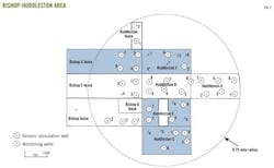
The Bishop-Huddleston project area (Fig. 2) is in Sharon Ridge (Clearfork) field about 10 miles southwest of Snyder in Scurry County, Tex. The producing intervals are the Glorietta at about a 2,300-ft depth and the Clearfork at about a 3,100-ft depth.
The first Glorietta-Clearfork tests on the tracts were in the late 1940s with cable tool rigs. These tests resulted in marginal production due to the relatively poor stimulation techniques available at the time. More successful development was in the mid to late 1950s with application of hydraulic fracturing.
A third development period was in the mid 1970s and early 1980s, probably spurred on by rising oil prices.
Waterflooding began in Sharon Ridge about 1977 and expanded over the years to include most of the field lying to the south of the project area. The flooding to date has been on a lease-by-lease basis by numerous operators. While the response to flooding has varied in the areas nearest to the project, the better areas have had secondary recoveries equal to primary recoveries.
Area geology
Examination of well logs, cores, sample logs, and production data of Sections 161 and 162 reveals the structure and character of several distinct productive and continuous zones of porosity in both the Glorietta-Upper Clearfork and Lower Clearfork.
Structural mapping of the Glorietta and Clearfork shows a north-northeast to south-southwest trending saddle positioned on the common boundary of Sections 162 and 161.
West of this saddle, the structure drops off rapidly into the Midland basin. On the east is a relatively flat area resting on the edge of the Eastern shelf, with a slight structural high in the southeast quadrant of Section 161.
The porosity zones typically have dolomitic porosity, consisting of common pinpoint to occasional vugular porosity created by diagenetic alteration of limestone and lime cement in the sandstones to dolomite due to the presence of anhydrite.
Glorietta, Upper Clearfork reservoir
The Sharon Ridge 2,400-ft reservoir in this area has five sand zones in the Glorietta and three dolomite zones in the Upper Clearfork at 2,300 and 2,600 ft in the Huddleston B No. 8 well. Each zone correlates fairly well on the neutron log and generally consists of 2-10 ft intervals with good neutron porosity often separated by 2-10 ft intervals of poor porosity.
These intervals typically have good sample and core oil shows, and previous operators generally perforated these intervals.
Zone AA is the shallowest and has an apparent sandy zone that has poor definition on core and sample data. Operators have rarely perforated this zone. It follows a general northeast-southwest trending pattern of channels and pinchouts and is not continuous over the entire project area.
Zones A, B, C, and D are all sheet sands that appear to cover the entire project area. Net porosity in these zones seems thickest in the west half and especially the southwest quadrant of Section 161.
Zones E, F, and G appear to be dolomite with no sand. The zones extend over the entire project area and probably were originally limestone that had unique character, such as being oolitic or fossiliferous, that favored dolomitization.
Operators typically perforated these lower zones in only the more recent completions, and these zones generally have greater water production on the initial test.
Displaying 3/5
View Article as Single page

